The NSGIC Geospatial Maturity Assessment (GMA) provides NSGIC members, business partners, and other peers with a summary of geospatial initiatives, capabilities, and issues within and across state governments.
This information is intended to assist state governments with setting goals, identifying peer states for collaboration, identifying areas requiring attention, and connecting with opportunities and resources. Completing the GMA also offers state governments a chance to reflect on their geospatial strategy, operations, and progress.
The assessment is performed every two years. The current assessment results were obtained in the second half of 2021.
In the links that follow, participating states' report cards can be found. Please reference the full report for more information on methodology, grading schemes, and national trends.
2021 Geospatial Maturity Assessment Full Report
States' Grades Summary Page
2021 Geospatial Maturity Assessment State Report Cards
Individual State Results
Statistics Document
The NSGIC 2021 Geospatial Maturity Assessment (GMA) Dashboard
In addition to the 2021 GMA report, the state report cards, and each state’s response, NSGIC has also published the results in an interactive geospatial web map application with dashboards that have been customized for each theme. The dashboards allow users to take a deeper dive into the results, interacting with individual state and collective national results bringing to life the visual patterns and trends in the data.
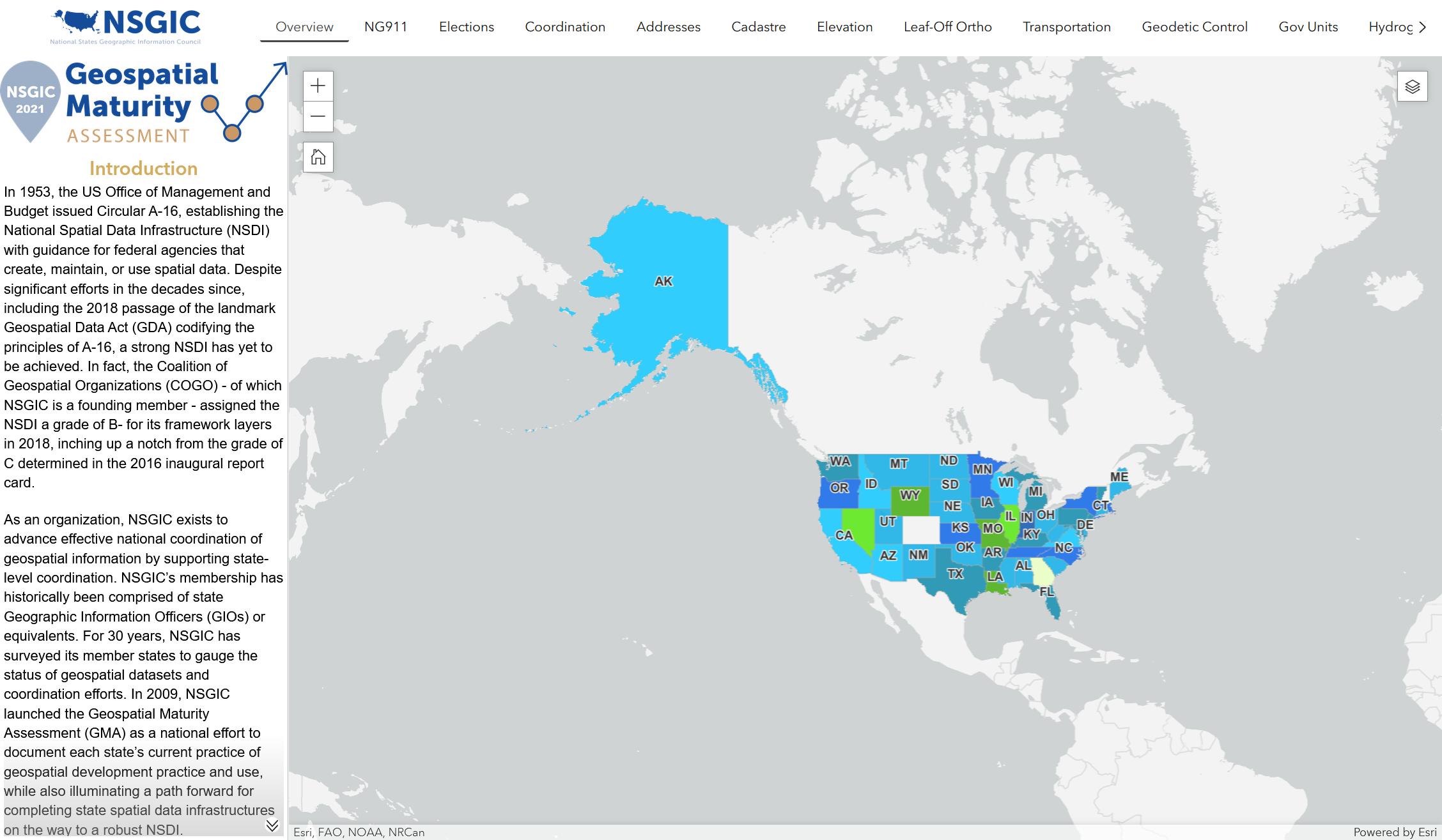
For best performance, click the image above to open the NSGIC 2021 Geospatial Maturity Assessment (GMA) Dashboard in a separate tab.
To assist individuals in their successful use of the NSGIC 2021 Geospatial Maturity Assessment (GMA) Dashboard, a help tutorial has been created to show how to navigate and use the interactive geospatial web map application. Click here to access and review the help tutorial.
NSGIC Best Practices for State Geospatial Maturity
Growing from the Geospatial Maturity Assessment, the NSGIC best practices series compiles best practices collected from “honor roll” states based on individual GMA report cards. In 2020, NSGIC released best practices for coordination, addresses, NG9-1-1, and transportation. To support our community in the future, using the latest GMA data, NSGIC will release best practices for cadastre, hydrography, elevation, and orthoimagery.
Addresses Best Practices | 2019 GMA, released in June 2020
Coordination Best Practices | 2019 GMA, released October 2020
NG9-1-1 Best Practices | 2019 GMA, released December 2020
Transportation Best Practices | 2019 GMA, released March 2021
NSGIC Geospatial Maturity Assessment Archive
2019 Geospatial Maturity Assessment
2017 Geospatial Maturity Assessment
For more information about the GMA, contact NSGIC's Sr. Manager of Applications and Technology: Emily Ruetz
|
