Filtered by category: Advocacy Clear Filter

NSGIC Names Cy Smith to New Policy Role

After serving many years as a NSGIC state representative, board member, and board president, Cy Smith has joined NSGIC’s staff team in the newly-created role of Policy Director. In this position, Smith will work with NSGIC leadership to develop, promote, and coordinate strategies that advance states’ geospatial interests linked to federal programs, congressional actions, and related initiatives. The new appointment coincides with Smith’s retirement from state government service in Oregon on Nov. 12, 2021.

“Cy has been an extraordinary contributor to NSGIC and the entire geospatial ecosystem for nearly three decades,” said NSGIC Executive Director Molly Schar. “We are very fortunate to welcome him in this new strategic role as efforts continue to evolve in support of a robust National Spatial Data Infrastructure.”

Smith began his career in statewide GIS coordination in Kansas in 1992. He quickly joined the national discussion about efficient and effective GIS coordination as a member of the original Federal Geographic Data Committee (FGDC) Framework Working Group in 1993 and 1994.

Read More

Senate Passes GIS Day Resolution Following Successful Passage of Geospatial Data Act

Senator Orrin Hatch (R-UT) and Senator Mark Warner (D-VA) led a Senate resolution to designate November 15, 2018 as “National GIS Day.” Senators Baldwin (D-WI), Blumenthal (D-CT), Capito (R-WV), Hassan (D-NH), Inhofe (R-OK), and Wyden (D-OR) joined Hatch and Warner in submitting the resolution.

“The Senate designates November 15, 2018, as ‘National GIS Day’; encourages users of Geographic Information System technology … [including] educators, students, and innovators to continue to employ GIS to learn and explore, to analyze and address societal challenges; and to drive economic growth for the betterment of the people of the United States and individuals around the world.” the three-page resolution concludes.

This recognition by the Senate punctuates the passage of the Geospatial Data Act, included as a component in H.R. 302, the FAA Reauthorization Act signed into law last month.

Read More

State Geospatial Policy Organization Lauds “Geospatial Data Act” Language Included in FAA Reauthorization Bill

Participants at the National States Geographic Information Council (NSGIC) Annual Conference cheered at the news that the Federal Aviation Administration (FAA) reauthorization bill passed the Senate this morning.

The legislation contains provisions critical to building the national spatial data infrastructure by establishing a clear vision, assigning responsibility, providing authority and ensuring oversight of federal activities by Congress. The bill includes language previously winding its way through both houses as a standalone bill called the Geospatial Data Act.

“This is a major win for the entire geospatial community. We thank and commend our nation’s lawmakers for enacting this meaningful legislation,” said Dan Ross, geospatial information chief for the state of Minnesota and NSGIC president. “NSGIC members coordinate geospatial policy, technologies, and services across our states. We have the unique perspective of seeing across states - and, together, across the nation - to evaluate the substantial and significant unmet needs stemming from a failure to harness and coordinate efforts. ”

Read More

Support for Geospatial Data Act More Critical Than Ever

In the last Congress - the 114th - some 9,600 bills were introduced. Less than 4% of them were signed into law. These are daunting numbers when you are pushing for a piece of legislation that you think is important enough to make it to the finish line. NSGIC has encouraged members of our community to support the Geospatial Data Act (S.2128 and H.R.4395) from the start, but that support has never been as critical as it is right now.

On a conference call with other member of the Coalition of Geospatial Organizations (COGO) this week, there was significant discussion about some of the issues standing in the way of unanimous support. Several organizations (NSGIC included) have been working to develop language palatable to associations with vastly different memberships. Folks in the open data/open government community have expressed concern about language around proprietary or licensed data being available on the GeoPlatform. Still others are caught up in a desire to include language related to licensure and procurement. Neither of these issues is appropriate to try to resolve in this bill. It should be noted, however, that the Geospatial Data Act is fundamentally an open data bill.

The irony is that without exception (to my knowledge, anyway), the geospatial community can agree that what the Geospatial Data Act is trying to accomplish is a good thing. The legislation codifies existing executive orders and other guidance documents that direct the work of the Federal Geographic Data Committee (FGDC), the body that promotes national coordination in developing, using, sharing and disseminating geospatial data. It gives the FGDC the authority to make federal agencies follow some existing common sense rules and provides Congressional oversight over the geospatial activities of FGDC members and other agencies. It provides a great deal more clout to input developed by the multi-sector membership of FGDC’s National Geospatial Advisory Committee. And very importantly to NSGIC, it requires federal agencies to coordinate and work in partnership with other federal agencies, agencies of state, tribal, and local governments, institutions of higher education, and the private sector with the collective goal of achieving a robust national spatial data infrastructure.

Read More

GIS Day Marks Reintroduction of Geospatial Data Act

This afternoon, the Geospatial Data Act (GDA) was introduced in the Senate by Senators Hatch (R-UT), Warner (D-VA), Heller (R-NV), Wyden (OR), Boozman (R-AR) and Klobuchar (D-MN) as S.2128 and in the House by Representatives Westerman (R-AR) and Moulton (D-MA) as H.R.4395. NSGIC has supported the GDA in a few different forms, it having been introduced in a previous Congress, as well as having undergone revisions since its last introduction. It has retained its critical core – developing a national spatial data infrastructure (NSDI) that will significantly improve government services for citizens across the country.
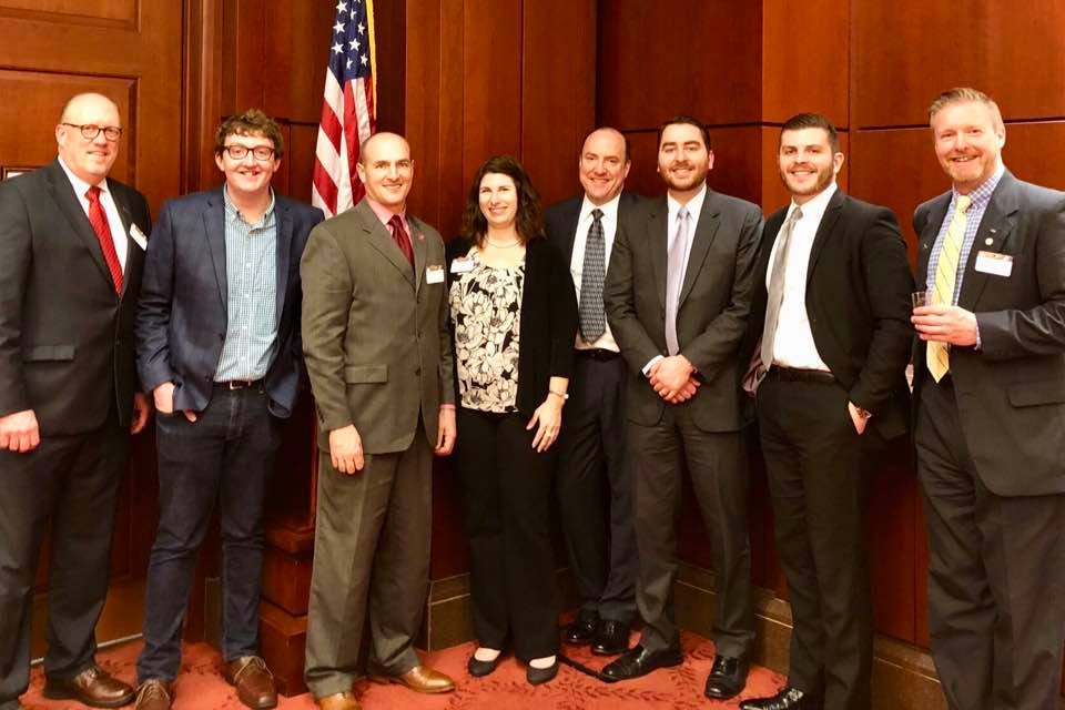
Working with partner organizations, we delivered a GDA support letter that included other well-respected national organizations and geospatial technology and services companies. It is the strongest showing of support for the GDA that has ever been garnered. I had the opportunity to join a few NSGIC colleagues – Cy Smith (OR), Shelby Johnson (AR), Dan Ross (MN) and our executive director, Molly Schar – for a Capitol Hill GIS Day reception we co-hosted with AAG and Esri. It was an excellent opportunity to speak with lawmakers and their staff members about why the GDA is so important, and it also gave us a chance to talk with the other nonprofit and corporate representatives in the room who are our partners in supporting this legislation. With transparent and coordinated advocacy efforts, we can leverage the momentum building in the geospatial community for this bipartisan, “good government” bill.

As I said in my remarks during the reception this afternoon, developing a national spatial data infrastructure is a concept that we have struggled with for the past 24 years – since the signing of Executive Order 12906 in 1993. The NSDI, as a concept, has mostly been an federal interagency pursuit, with little comparatively little consideration to harnessing the significant geospatial capabilities that state, tribe, regional or local governments, and the commercial sector have developed in the past two decades. The GDA codifies a strong multi-sector governance structure for NSDI strategy and activities, and it mandates Congressional oversight of federal geospatial expenditures. There are two specific provisions of this bill that NSGIC believes will be difference makers toward the achievement of a fully functional, and truly 'national' spatial data infrastructure.

Read More

Geospatial Data Act: NSGIC's Position in a Nutshell

Over the weekend, I fielded an inquiry from long time colleague in a related geospatial field: "What is NSGIC's current stand on the GDA legislation?"

My response encompassed three points, with which NSGIC has been consistent:

  1. NSGIC supports the Geospatial Data Act,
  2. NSGIC acknowledges the importance of further improvements that seek to build consensus support for the bill across the geospatial professional community prior to it being heard by Committee, and
  3. NSGIC is actively participating on a working group within the Coalition of Geospatial Organizations (COGO), with the hope of delivering recommended modifications to the bill prior to October 1.

More specifically, we feel that the focus should now be on finding agreement on how any reference to geospatial procurement and licensing can be balanced to best represent current practices. This is because on the whole, we don't feel there is too much that is in need of a fix in these areas in the real world.

Read More

Geospatial Data Act: The Latest

I’ll start by saying that NSGIC’s position continues to be that we support the Geospatial Data Act of 2017. From the perspective of the state geographic information officers and coordinating bodies, the GDA charts a course for a true, useful, robust national spatial data infrastructure. This includes positioning the Federal Geographic Data Committee (FGDC) within the Office of Management and Budget, collaboratively sustaining the GeoPlatform for shared national data services, recommitting to the importance of data standards, and advancing other long-term strategic goals for geospatial infrastructure.

The GDA asks federal agencies (except where doing so would compromise national security) to look at where and how they spend money on GIS, and to provide that information to Congress. This is good stewardship of taxpayer dollars, because it will allow Congress and the public to see where efforts could be better aligned and cost savings achieved. And it looks not just at efforts that are overlapping between federal agencies, but also work being done at the state and local levels. This is important - you can’t manage well without measuring.

The GDA also strengthens the ability for non-federal stakeholders, including the private sector and academia, to provide input as part of the National Geospatial Advisory Committee (NGAC) to the FGDC. The FGDC, NGAC, and other governance constructs would all benefit from being codified into law by the GDA, versus the existing policy that is supported largely in the form of executive order.

Read More

Important Opportunity to Provide Geospatial Guidance to FCC

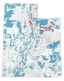
When the FCC employed census blocks for Form 477 broadband coverage mapping in 2014, thousands of rural Utah addresses (red) suddenly appeared as covered by the expanded census block service areas (blue).

Important Updates

Read More

NSGIC Stands Behind Geospatial Data Act, Lauds New Language Clarifying Intent

The Geospatial Data Act (S.1253) has been the subject of much discussion in the past couple of weeks after receiving significant attention by some members of the geospatial community concerned about the potential of the proposed legislation to add restrictions to federal procurement of geospatial data and services.

NSGIC - the voice of the states on geospatial issues - continues to support S.1253, expected to be stronger than ever after minor language revisions that clarify the original intent of the bill to substantially strengthen efforts to build a robust national spatial data infrastructure (NSDI) and reduce duplication of data gathering and processing activities. The changes to S.1253 focus on Sections 2 and 11 and clarify that the intent of the bill is not to expand the scope of the Brooks Act or the Federal Acquisition Regulation (FAR).

“We are pleased Senators Hatch, Warner and Wyden, co-sponsors of the Geospatial Data Act, are actively working with members of the geospatial community to address a misconception raised by several stakeholders regarding the intent of the bill,” says NSGIC President Bert Granberg. “This bill will be stronger, and it will better position the nation for increased benefits from the use of map technologies to drive efficiency in all activities from everyday services, infrastructure management, economic development, and even large scale disaster response.”

Read More

Geospatial Data Act Sets Table for Performance and Accountability

Legislation would benefit taxpayers and entire geospatial community

There simply is no change to professional licensing requirements and no expansion of the Brooks Act or other changes to the federal procurement process in the Geospatial Data Act.

For as long as NSGIC has been around – more than 25 years now – we’ve encouraged effective and efficient government through the coordinated development of geographic information and technologies to ensure that information may be integrated at all levels of government.

The Geospatial Data Act (S.1253) does just that. It establishes a clear vision, assigns responsibility, provides authority and ensures oversight by Congress of federal geospatial activities. These improvements will help ensure that the United States is able to build and sustain a robust national spatial data infrastructure (NSDI). Support of this legislation is a critical step toward building more resilient communities by ensuring they will have access to the consistent high-quality data they need.

Read More

Major Movement for NSGIC Legislative Priorities

Both the Geospatial Data Act and the Digital Coast Act had big days yesterday. The bills are making their way through the 115th Congress after stalling out in prior years.

The Geospatial Data Act of 2017 was introduced yesterday by Senators Orrin Hatch (R-UT), Mark Warner (D-VA), Dean Heller (R-NV) and Ron Wyden (D-OR) as S.1253. Over the course of the last few years, NSGIC has worked closely with other stakeholders to provide input with the states' perspective on improving the coordination and use of geospatial data.

NSGIC president Bert Granberg said this upon the bill's reintroduction: "From transportation, to natural resources, to homeland security, map-based digital information has quietly become mission critical to how work gets done and to future economic growth. We need an efficiency and accountability framework to build, sustain, and share geographic data assets for the entire nation. The GDA delivers just that." (Read more in the press releases put out by Senator Hatch and Senator Warner.)

Read More

NENA NG9-1-1 GIS Data Model Available for Public Review

The National Emergency Number Association (NENA) recently released the NENA Standard for Next Generation 9-1-1 (NG9-1-1) GIS Data Model for public review.  Under development for over 6 years, the NG9-1-1 GIS Data Model is designed to support civic location address data management in a NG9-1-1 System. NENA was a major participant in the development of the FGDC’s United States Thoroughfare, Landmark, and Postal Address Data Standard and closely aligned the NG9-1-1 Data Model to the FGDC Standard, but it does have some differences.

The public is invited to review the document and submit comments following the instructions below (direct link https://dev.nena.org/kws/public/document?document_id=9828&wg_abbrev=csds-gis). Comments will be accepted until February 28.

A NSGIC 30-minute webinar about the standard was recently held and is now available on NSGIC’s NG9-1-1 library page (https://www.nsgic.org/next-generation-9-1-1). Those interested in commenting on the document are strongly urged to first review the webinar as it explains what the NG9-1-1 GIS Data Model Standard is, how the document is structured, the GIS data layers needed in a NG9-1-1 system, their structure and use in required NG9-1-1 functional elements, items deferred for future work, how to participate in the public review, and the document’s relationship to other NENA GIS-related standards.

Read More