Filtered by category: National Clear Filter

Joint Statement on the Value of GIS in the Pandemic

The spread and effects of COVID-19 can be best understood considering space and time.

As governments are responding to COVID-19, more leaders are recognizing the value of “knowing the where.” The importance of knowing where the outbreak is growing, where high-risk populations are, where the hospital beds and important medical resources are, and where to deploy resources is essential. “Knowing the where” informs better decision-making.

In an effort to better understand the where, governments are recognizing the value of geospatial information and technologies and are engaging geospatial professionals to help them better understand the where to help them in their decision-making and response. Geospatial professionals bring unique analytical and visualization skills to the table that help responders and decision-makers visualize where the pandemic is spreading more quickly and can make the important decisions regarding where response and resource needs need to be focused. The value of telling the story through a map coupled with a geospatial dashboard provides a view of the event not readily seen in a table such as a spreadsheet. Beyond visualizing existing data, we can connect data from a location perspective, which enhances the value of the data sources being integrated. Equally important in this event is data on COVID-19 cases and testing packaged and shared in a way useful to scientists.

GIS (geographic information systems) is experiencing an unprecedented level of use. Historically, GIS was deployed following a disaster to help respond and recover. Today, GIS is used as a disaster is unfolding. The COVID-19 event is an outstanding example of how effective GIS is when robust data is available. Governments are realizing the value of investing in these systems and the people who run them.

Read More

Coming Together for Next Generation 9-1-1: State GIS Coordinators, 9-1-1 Boards, and Public Safety Answering Points

Next Generation 9-1-1 (NG9-1-1) is a ‘game changer’ for the 9-1-1 community because it will utilize GIS technology to deliver every 9-1-1 call —mobile, VOIP, and landline — to public safety answering point (PSAP) centers with precise geographic coordinates.

NG9-1-1

  • Uses authoritative GIS data for call routing and location validation
  • Conducts real-time two-way voice, text, and video emergency calls via IP-based networks
  • Accesses personal sensor notifications—including collision detection and medical alert systems
  • Better location data result in fewer misrouted calls, and an IP-based network of networks will simplify transferring emergency calls and associated data to other PSAPs
  • Interoperable data standards enable PSAPs to better assist each other in emergencies
  • Improves area-specific multi-media emergency alerts to wireline and wireless devices

PSAPs will be required to use up-to-date and standardized geographic information thatare regularly shared to regional and/or statewide datasets, including:

  • Civic location data including address points and road centerlines that have been synchronized with MSAG and ALI databases.
  • Emergency service boundaries, including law, fire, EMS and PSAP boundaries that are free of gaps and overlaps and have been coordinated with neighboring jurisdictions.
  • Provisioning boundaries, which define who is responsible for providing the above GIS datasets for a specific geographic extent.

While states across the country are in various stages of preparation for implementation of the next generation of 9-1-1 (NG9-1-1), it is clear that strengthening relations with state 9-1-1 leadership and PSAPs is critical to the success of NG9-1-1.

Read More

Will Your State Host NOAA's Next Digital Coast Fellow?

Over the past year, former Alaska Sea Grant research trainee Richard Buzard has been working with the Alaska Division of Geological & Geophysical Surveys Coastal Hazards Program in Anchorage, Alaska to help rural Alaskan coastal communities understand flood impacts and respond to coastal storms, and develop flood impact guidance for coastal mapping on the last frontier.

Rich was partnered with mentor DGGS Coastal Hazards Program (CHP) lead scientist and program manager, Jacquelyn Overbeck, as part of NOAA's Digital Coast Fellowship program.

The NOAA Coastal Management Fellowship and Digital Coast Fellowship Program matches postgraduate students with key NOAA partners to work on specific projects for two years. The program provides fellows with professional mentoring and training and the hosts with technical assistance to help them manage the coast effectively.

Read More

COGO releases 2018 Report Card on the U.S. National Spatial Data Infrastructure (NSDI)

The Coalition of Geospatial Organizations (COGO) has announced the release of its 2018 Report Card on the U.S. National Data Infrastructure (NSDI). The report card utilizes a letter grading system to depict the status and condition of the nation’s geospatial infrastructure.

Notably, the national assessment of the NSDI’s ability to meet future geospatial data, based on address, cadastral, elevation, geodetic control, government units, hydrography, orthoimagery, and transportation themes, rose from a C in the 2015 Report Card, to a B- in the 2018 Report Card.

“The new report card exemplifies that while progress has been made, federal, state, regional, and local government agencies, tribal nations, and private and academic sectors need to continue to collaborate to complete this important work,” says NSGIC President Dan Ross. “NSGIC fully supports that collaboration and will continue to work with our members to support and move this initiative forward.”

Read More

Homeland Security Study Focusing on GIS Infrastructure for Disasters

On NSGIC’s behalf, I recently attended the second workshop of the DHS Disasters Interoperability Concept Development Study being conducted by the Open Geospatial Consortium (OGC).

This workshop follows the announcement that the Department of Commerce Economic Development Administration has $587 million in FY18 supplemental appropriations available for disaster recovery grants.

For the concept development study, OCG is bringing together key stakeholders in the natural hazards disaster communities to assess the current state of data and product exchange technologies used in disaster planning, response, and recovery. The results will aid in developing a series of pilots to advance the state of spatial data infrastructures that support global disaster risk reduction.

Read More

Mapping the Last Frontier: NOAA Award to Assist Alaska's Rural Coastal Communities

Alaska was recently selected to receive a 2018 - 2020 Digital Coast Fellowship. This award will provide long-term benefits for Alaskans who reside in coast communities, 80 percent of whom are vulnerable to extreme weather events and storm flooding.

The project - titled Bringing Alaska Coastal Communities Online to the Digital Coast: Coastal Flood Mapping for Rural Alaska - will build upon existing data, online mapping tools and partnerships to assist Alaska in responding to coastal flood hazards. This includes efforts to:

  • Develop a coastal flood forecast and catalog map tool

Read More

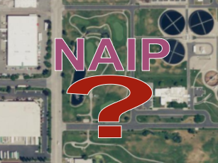
Is the Future of NAIP Aerial Photography in Trouble?

Potential changes to the USDA's NAIP one-meter color aerial photography program were a hot topic of discussion at today's FGDC Coordination Group meeting.

In response to reduced funding, USDA is currently reevaluating the efficacy of the NAIP program. Reduced funding for NAIP is due to agency budget cuts, partially met commitments by federal partner agencies outside of USDA, and later-than-desired transfers of partner funding that require USDA to take on extra financial risk.

Accordingly, the NAIP acquisition contract renewals will be for one year only in 2018 and the NAIP flights are slated to move back to a three-year cycle. Notably, USDA is considering subscribing to a commercial imagery subscription starting as early as 2019, and has determined that a USDA-only COTS license would meet USDA needs while cutting their internal acquisition costs by 50% and improving resolution by 2x. USDA also stated that it was clear that it would only take a few agencies acquiring their own exclusive commercial imagery subscriptions before those costs exceeded the overall cost of NAIP.

Read More

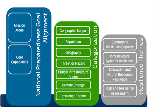
Community Resilience Indicators and National-Level Measures: A Draft Interagency Concept | FEMA.gov


Source: Community Resilience Indicators and National-Level Measures: A Draft Interagency Concept | FEMA.gov

White House Office of Management and Budget Releases New Report to Support Community Resilience

On December 21, the White House Office of Management and Budget (OMB) released a new report titled "Standards and Finance to Support Community Resilience," the culmination of collaboration with leaders in re/insurance, catastrophe modeling and building science to advance community resilience and insurability.

The White House: Supporting Resilient Communities: Leaders in the insurance industry are announcing new investments to support resilient communities - Here's Why

NAFSMA Press Release: White House Office of Management and Budget Releases New Report to Support Community Resilience