Filtered by category: Partner Insights Clear Filter

How to Make the Most of the NSGIC Emerging Partner Program - A Perspective from makepath

Is the NSGIC Emerging Partner program right for you? If you are a new company considering whether to partner with NSGIC, this blog post was written for you.

We are makepath, a geospatial data science company focused on Open Source GIS, Open Source Machine Learning, and Visualizations. We were founded in Austin Texas in February of 2020. We joined NSGIC as an Emerging Partner in mid-2020.

The bottom line is we have found our partnership with NSGIC to be a great long-term investment.

Read More

Sponsor Spotlight: Planet

Streamlining Operations in the New Normal: Leveraging Satellite Data for Conservation and Compliance

The COVID-19 pandemic has sparked a “New Normal” for State, Local, and Tribal governments across the U.S. that is likely to last. This “New Normal” of more limited resources, uncertainty, and distributed teams presents unprecedented challenges for land use monitoring as the demand for water resources, agricultural yields, grazing land, and urban expansion continues to grow. It’s harder to maintain a reliable and updated view of what’s happening on the ground as field operations become slower and more expensive.

More advanced, complete datasets are needed to break down silos of information and increase efficiency. Planet delivers near-daily, high-resolution satellite imagery, reliably processed and delivered within hours of capture. Organizations across the country are using Planet data within their existing workflows to grow and meet these challenges head-on.

Read More

Sponsor Spotlight: Geo-Comm

Public Safety Grade GIS Data is Critical for Public Safety Emergency Response Systems

With GIS data playing a key role across E9-1-1, Next Generation 9-1-1(NG9-1-1), Emergency Communication Center (ECC) and responder tactical mapping systems and applications, and now indoor and vertical 9-1-1 caller location, it has become an imperative for 9-1-1 to implement Public Safety Grade GIS data. These mission critical life safety systems and applications rely on GIS data to drive emergency response - helping to save lives and protect property. This GIS data must be highly accurate, highly secure, highly available, up-to-date, and commonly accessible to all mission critical life safety applications across 9-1-1 and public safety organizations.

While the 9-1-1 industry is aware of the mission critical role of GIS in NG9-1-1, new pressures, requirements, and urgency for achieving standardized Public Safety Grade GIS data are emerging as our world increasingly becomes data driven. Today, 9-1-1 and public safety entities are facing more and more challenges related to the explosion of multiple geospatial datasets copied to many applications, users, and locations across the 9-1-1 and public safety enterprise.

Read More

Sponsor Spotlight: Ecopia

3D Nationwide Landcover - A New Geospatial Frontier

The emergence of very high-resolution (VHR) commercial imagery products, both satellite and aerial, has led to an increased demand for high-accuracy derivative data.

Historically, derivative products created at a countrywide scale were produced to a 30-meter, or at best, 10-meter resolution. Ecopia has shifted the paradigm of data extraction by leveraging the power of artificial intelligence (AI) and readily available high-resolution imagery. With access to both VHR aerial and satellite imagery through our network of imagery partners, Ecopia has established a streamlined workflow to produce high-resolution vector data across the globe.

Read More

Sponsor Spotlight: Hexagon


The HxGN Content Program, Hexagon's aerial data program, offers the largest library of high-resolution multispectral aerial imagery and elevation data of the United States. For state and local governments, Hexagon provides a flexible licensing model that enables stakeholders to tailor data collection to their exact specifications.

Trevis Gigliotti, Director, Technical Content Solutions at Hexagon, explains how state and local governments can benefit by partnering with Hexagon.

The geospatial imagery space has evolved significantly over the last decade. What are some notable trends we're seeing today?


Read More

Sponsor Spotlight: NV5 Geospatial

With the recent acquisition of Geodynamics LLC, NV5 Geospatial has built one of the most comprehensive suites of solutions for geospatial surveys of deep water and near-shore environments. The combination brings together complementary, advanced technologies – Geodynamics’ full-ocean depth sonar-based hydrographic and geophysical surveying with NV5 Geospatial’s topographic and bathymetric capabilities – to deliver detailed insights for a variety of applications, including coastal management, flood monitoring, ecosystem protection, research, and more.

“This acquisition was a natural evolution toward our common goal of delivering valuable geospatial insights to our clients,” said Kurt Allen, vice president, Federal Vertical for NV5 Geospatial, North America’s largest and most comprehensive geospatial firm. “Our decades of combined experience and expertise using the most sophisticated technology for data acquisition and analysis will enable us to meet the most demanding client requirements.”

Only a handful of firms in North America share NV5 Geospatial’s topobathymetric and bathymetric capabilities at any level, much less have mastery of the science. We lead our peers in acquisition capabilities. We deploy leading-edge sensors like our newly acquired RIEGL 840 G. We have world-class experts managing the challenging data processing and developing informed answers that our government and commercial clients demand. In 2020 NV5 Geospatial completed the collection of topographic and bathymetric lidar and digital imagery for the National Oceanic and Atmospheric Administration’s (NOAA) largest coastal mapping project. These efforts included updating information for 12,000 square miles along the Eastern Seaboard, Pacific, and Gulf Coast that have not been surveyed for hundreds of years.

Read More

Sponsor Spotlight: DATAMARK

The technical and organizational complexity of GIS for Next Generation 9-1-1 is just one of the many considerations for decision makers when determining an NG9-1-1 solution. Whether the deployment will be PSAP-by-PSAP, County-by-County, or as a regional or statewide implementation, one common goal is the seamless connectivity of data to support the 9-1-1 caller. To prepare for this level of interoperability, 9-1-1 and GIS decision makers have the added challenge of how to best meet NG9-1-1 needs and requirements while still recognizing the autonomy of the many data providers that have the added responsibility of supporting the business needs of their individual communities.

The complexity of a GIS ecosystem can grow exponentially when one considers the scope of the various deployment “patterns” that are possible to meet the data validation, aggregation, and provisioning requirements for multi-jurisdictional entities. It is quite common for adjoining jurisdictions to have completely different GIS data that has widely varying data quality and is updated on similar varying update cycles. The management challenge grows as each adjoining jurisdiction is added to the larger collaboration effort.

Scalable solutions that allow for iterative validation and aggregation from multiple sources into a single database help to ensure the capability to support the interoperable needs of NG9-1-1. The ability to:

Read More

Sponsor Spotlight: TeachMeGIS


‘Collaboration allows us to know more than we are capable of knowing ourselves.’ –Paul Solarz


It’s a fantastic thing to see figurative lightbulbs go on across the room at NSGIC meetings and in the socials as the top GIS professionals from every state come together to share knowledge and ideas.

At TeachMeGIS, we see this happen on a smaller scale nearly every day during our GIS classes. The instructor demonstrates a spatial join tool, and someone with point data says, “Hey you, you with the polygon data, let’s try this! I’ve needed this for years!”

Read More

Sponsor Spotlight: makepath

Equip Your GIS Analysts with Easily Scalable Tools

In this post, makepath will spotlight two tools that are great because they scale well, especially as the scope of a project grows. Scalability is gold in the GIS world.

Xarray-Spatial

Read More

Partner Spotlight: GeoComm

Accurate GIS data is important throughout 9-1-1 emergency response and has a critical role in NG9-1-1 by determining which Public Safety Answering Point (PSAP) to route a 9-1-1 call to. This process of geospatial call routing enables better accuracy than traditional 9-1-1 systems and can reduce the number of 9-1-1 calls transferred due to misrouted 9-1-1 calls.

For the last 25 years, GeoComm has been working to help GIS and 9-1-1 teams across the country understand the role GIS plays in 9-1-1 and NG9-1-1, empowering them to achieve public safety grade GIS. Our assess, improve, and maintain proven process tackles the common obstacles agencies face when working to implement an NG9-1-1 system. Because the NG9-1-1 services utilized in this approach are simple and straightforward, they are easily adaptable for jurisdictions of all sizes including local, regional, and statewide.

Read More

Partner Spotlight: Fugro

Shining a Light on Change with Recurring Lidar Programs

Our landscape is in a state of constant change. Cities and towns are expanding at a rapid pace, while natural disasters are rearranging rivers, eroding shorelines, and crumbling infrastructure. To effectively manage change, we need geospatial data that is both fit-for-purpose and recurrent, as well as visualization tools to communicate this information to a wide range of stakeholders.

The Value of Recurrent Lidar Data

Read More

Partner Spotlight: Hexagon

The Importance of Geospatial Data Intelligence in Times of a Global Pandemic

As the COVID-19 global pandemic keeps the world on edge and uncertainty has sparked historical volatility in the global markets, there has been ample opportunity to reflect on how location intelligence data can aid reaction, response, and recovery in this unprecedented scenario.

Government customers of Hexagon’s Geospatial division have used its M.App Enterprise platform to develop and implement dynamic monitoring systems to close the gap between location information and critical operations. These maps and dashboards are empowering officials and citizens to make informed decisions about procuring essential items, tracking local infection rates, proposing countermeasures, and communicating the most effective ways to stay safe.

Read More

Partner Spotlight: Dewberry

Power of Partnerships: Standardizing and Streamlining Preliminary Damage Assessments

In 2019, there were 100 major presidentially declared disasters in the U.S. providing recovery assistance to 39 affected states and territories. In order to obtain a presidential declaration, a governor or tribal chief must submit a request to their Federal Emergency Management Agency (FEMA) regional office for assistance. This request includes preliminary damage assessment (PDA) information to document the extent of the disaster and its impact on individuals and public facilities. PDA information is used to show that the disaster is of such severity and magnitude that supplemental federal assistance is necessary for response and recovery efforts. For severe or catastrophic events, a governor or tribal chief may submit a declaration request prior to performing a PDA.

At Dewberry, we understand that dealing with the aftermath of a disaster is a stressful and trying time. Documenting damages can take time and resources that are better spent focusing on response and recovery efforts. Disasters are increasing in frequency and severity, therefore a streamlined approach to documenting damages makes the process of submitting declaration requests faster—facilitating an expedited recovery process. In partnership with ArdentMC, Dewberry supports FEMA, states, territories, and local agencies to help better quantify and quickly assess damage in an effort to expedite needed aid to impacted communities. We are now helping to facilitate and simplify the PDA process in an effort to decrease assistance timelines. Under this contract work with FEMA, the team is providing subject matter and technical expertise to help standardize collection of incident reported damage assessments in impacted areas using newly designed Esri Survey123 templates. These templates use GIS technology to electronically collect, submit, and validate damage assessment in a standardized and sharable way. The platform being used to manage the data collection is hosted in an Amazon Web Services (AWS) GovCloud region and is accredited by the Department of Homeland Security (DHS). Utilizing ArdentMC’s AWS competency in public safety and disaster response, coupled with Dewberry’s gold partnership with Esri, the PDA team has created a highly scalable collection platform for FEMA’s damage assessment mission.

Read More

Partner Spotlight: Safe Software

Data-Driven Decisions in a Real-Time World

Top Data Integration Trends in 2020

Working with location-based information and analytics in 2020 involves a more complex set of challenges than ever: we have to manage huge data volumes, real-time information streams, and a rising number of systems that produce and consume data. Governments and other organizations need to harmonize information to ensure all datasets are up to date, comply with standards, and deliver high-quality data wherever it’s needed. This is why data integration workflows have become a crucial part of operations for companies around the world.

Here at Safe Software, we designed FME 2020 to help you tackle these challenges and more. Let’s look at the top industry trends in 2020 and how you can take your organization to the next level using data integration workflows.

Connect Real-Time, High Volume Datasets

Read More

Partner Spotlight: AppGeo

NSGIC Annual Conference: Five Things on Our Minds

It’s been 55 years since Bob Dylan penned the times they are a-changin’, but that sentiment is truer than ever today in the world of GIS. Although we could make a lengthy list of things a-changin’, we’ve picked these top five, which we feel are particularly relevant to state GIS leaders. We look forward to conversations with you in Snowbird!

  1. Strategic planning 2.0 -- Many states haven’t done a full-on strategic plan since the FGDC Cooperative Agreement Program (CAP) grants from a decade ago. There’s been a whole lot of change since then, with new players, new paradigms for data access, new technology options, new political realities, and more. In our view, we need a change, a v2.0 approach to strategic thinking about the roles and goals of geospatial and its societal impact. A strategic plan sets the course for both vision and activities in a state GIS office, so this piece is very, very important.
  1. Geospatial Data Act -- It’s finally federal law, which means that it’s finally time for the US (and us!) to get serious about building and supporting a shared set of national geospatial capabilities. States will have a key role as the middle layer between national and local level participants in this endeavor. There are also opportunities to connect some national geospatial data silos, such as Next-Generation 9-1-1 and the National Address Database, which we need to move from idea to reality. This ties in nicely with v2.0 strategic planning, which is a formal responsibility of the Federal Geographic Data Committee (FGDC) under the new law. Ideally, the FGDC would again step up and provide support for the level of multilateral, nested strategic planning needed to engage the broad and diverse geospatial stakeholder community.
  1. New urgency on environmental problems -- We’re facing ever more urgent problems with more potent hurricanes and storms, greater wildfire threats, increased flooding potential, accelerating human consumption of natural resources, and many other issues. All of these need geospatial analytics to understand, and even predict the risks we now face and to develop solutions. If you are a parent (and even if you are not), these environmental issues should concern you and spur you to engage as truth-tellers with GIS.
  1. The shifting sands of geospatial data sources -- It wasn’t that long ago that government was the primary source of most GIS data, but that is becoming less and less true. We are seeing huge geospatial data investments from global internet companies, the auto industry, new imagery providers, and an explosion of data coming from sensors and “things” everywhere. This shift requires a rethinking and repositioning of the role of state GIS offices as the [providers/aggregators/curators/distributors] of geospatial data. See also, strategic planning, v2.0, above.
  1. Addresses, addresses, addresses -- It has become increasingly clear that address data containing accurate lat/long coordinates attached to every street address record is so fundamental to so many important uses, that we need to redouble our effort to get this done right, and done in a way that leverages the support resources and capabilities of many separate constituencies who will otherwise continue to work on address data separately. Oddly enough, this ties in with v2 strategic planning.

You might have a different list of top five issues, and we’d love to hear them. We look forward to having some great conversations with you at the NSGIC conference. For us, it’s the best event of the year to talk with the top geospatial thinkers and movers. We can share our observations with you that come from the rich variety of projects we’re involved in across the country. And we love to hear your perspective on what you see a-changin’ from the driver's seat as state GIS leaders.

Read More

Partner Spotlight: GeoComm

Accurate GIS data is important throughout 9-1-1 emergency response and has a critical role in NG9-1-1 by determining which Public Safety Answering Point (PSAP) to route a 9-1-1 call to. This process of geospatial call routing enables better accuracy than traditional 9-1-1 systems and can reduce the number of 9-1-1 calls transferred due to misrouted 9-1-1 calls.

For the last 25 years, GeoComm has been working to help GIS and 9-1-1 teams across the country understand the role GIS plays in 9-1-1 and NG9-1-1, empowering them to achieve public safety grade GIS. Our assess, improve, and maintain proven process tackles the common obstacles agencies face when working to implement an NG9-1-1 system. Because the NG9-1-1 services utilized in this approach are simple and straightforward, they are easily adaptable for jurisdictions of all sizes including local, regional, and statewide.

Read More

South Central TX LiDAR Project

Enhanced Hydrology in Texas LiDAR by Merrick-Surdex JV Critical to Risk Mapping

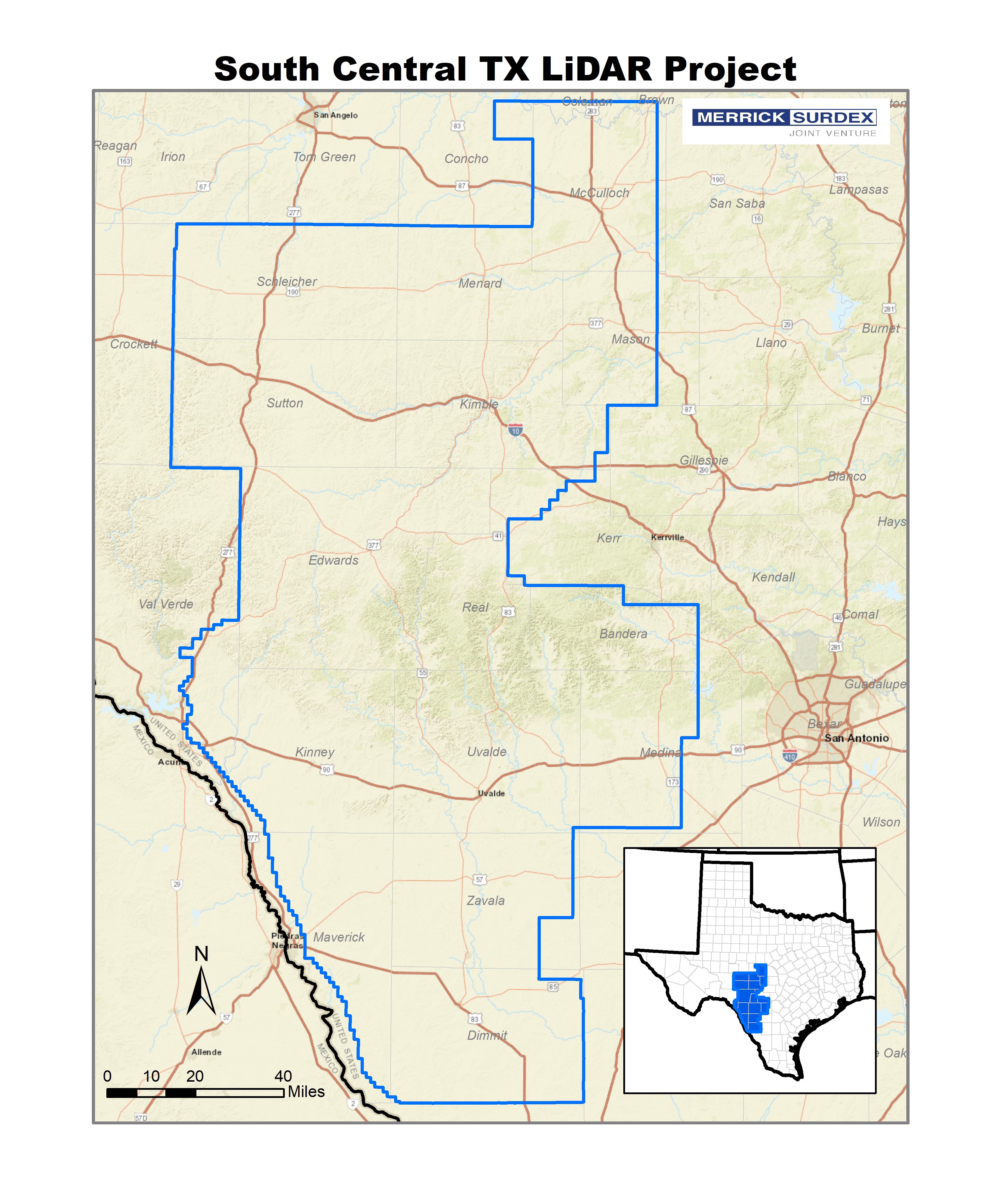
In 2017 the USGS selected the Merrick-Surdex Joint Venture to collect and process LiDAR data of approximately 17,950 square miles in Southwest Texas. One of the funding partners to the project, FEMA, required new elevation data in order to reclassify older hydrographic features to improve flood map accuracy. The data will be used to assist in risk management of potential flooding areas, due to significant shifts in precipitation over the past decade.

The State of Texas has experienced a nearly decade-long drought; in February 2018, nearly 90% of the state was under a drought warning. Within one year, these conditions shifted dramatically – in 2018, rains had been so persistent and heavy that by October less than 5% of the state was under a drought warning. This sudden increase in such a large volume of water has created a scenario with a notable risk of overflowing and flooding of once-dry riverbeds. The state consequently switched from a drought status to a situation of potential widespread flooding, with all the subsequent possibility of damage. FEMA and Texas Water Development Board (TWDB) anticipating the effects of such a situation, initiated a project with the USGS to obtain data to manage this new condition.

The Joint Venture’s effort towards the collection of hydrographic features was designed to exceed the USGS project specifications and to ensure map accuracy so that hydrological events could be monitored with confidence. Production staff invested a higher than normal amount of time and effort to identify stream banks that have been undefined by water for years due to drought. According to version 1.3 of the USGS LiDAR Base Specification, the minimum width for the collection of inland streams and rivers is 100 feet however due to the low water levels there are multiple instances where these features were as narrow as 10-15 feet and ordinarily would not have been collected. In several cases, widths varied considerably along the same stream, and had the only the portions of rivers/streams greater than 100 feet been collected, it would have resulted in disconnected networks of drainage. Additionally, several lakes/ponds would have been omitted for not meeting the minimum two-acre size criteria. These conflicts of elevation in the hydro-flattened Digital Elevation Models (DEMs) would have limited the data usefulness to all agencies. The process chosen will ensure map accuracy and hydrological events could be monitored with confidence.

Read More

Carpe Geo: Becoming a Great GIS Leader

How can you grow into the GIS leader you aspire to be? How can you work better with others? How can you get the most satisfaction out of your GIS career? These are questions that AppGeo believes can be answered through thoughtful application of Carpe Geo principles. Carpe Geo is about seizing the opportunities to do great things with GIS.

Those of you who attended the 2017 NSGIC Annual Conference in Providence, RI may remember hearing Bill Johnson’s Carpe Geo & Parvum Momentum presentation, where he first introduced us to these ideas. Since then, Bill has joined the AppGeo team and at this year’s NSGIC Annual he followed up with Carpe Geo, Part Deux, which explored how the principles of Carpe Geo can help you become a better GIS leader.

Becoming a great GIS leader doesn’t happen overnight. To better understand how one grows and metamorphosizes into that role, consider three lenses or models that can help you understand the growth path.

Read More

CREAT Climate Scenarios Projection Map

Contributed by: Nathalie Smith, Esri

EPA's Climate Resilience Evaluation and Awareness Tool (CREAT) Climate Scenarios Projection Map. This map provides easy-to-access scenario-based climate change projections drawn from CREAT. The impacts from a changing climate, including extreme heat and more intense storms, present challenges to water, wastewater and stormwater utilities and the communities they serve. Understanding how climate change may affect a utility's ability to maintain and deliver adequate, reliable and sustainable water supplies and clean water services is the first step in climate-related planning.

Read More