NSGIC Latest News

NSGIC Launches "Geo-Enabled Elections" Project to Enhance Elections Management with Geospatial Data & Technology

Today, the National States Geographic Information Council (NSGIC) announced a two-year project dubbed “Geo-Enbled Elections” Project to boost state-led efforts to standardize the application of geographic information systems (GIS) to support elections management and engagement between office holders and their constituents. These essential upgrades will benefit voters by increasing political boundary precision—so they know with certainty who represents them and what will be on their ballots each election.

The Geo-Enabled Elections Project will compile and promote best practices for the use of GIS to develop and sustain a map-based digital database to support state election offices that contains:

  • State, municipal, and local service district boundaries
  • Voting precinct boundaries, precinct assignments, and polling places
  • Constituent service areas to connect residents to elected officials, government services, public notices, and other location specific information

“The information systems behind our elections process can benefit greatly from integrating precise, authoritative geographic data. This has never been more important, as it will enhance efficiency and integrity while laying the groundwork to better connect constituents with their representatives and available government services” said NSGIC Executive Director Molly Schar. “In partnership with the bipartisan Democracy Fund Voice, we will be working to dramatically enhance the quality, efficiency, and collective trust in election systems in states across the country.”

Read More

Happy Ada Lovelace Day - Celebrating Women in STEM

Today is Ada Lovelace Day, a day to celebrate the achievements of women in science, technology, engineering and mathematics (STEM).

I first became aware of this celebration three years ago by happenstance when a friend of mine simply asked, "Are you doing anything special on Ada Lovelace Day?" I wasn't - I had no idea who Ada Lovelace was and what Ada Lovelace Day was about. Wikipedia quickly filled in the blanks.

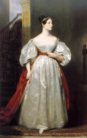
Augusta Ada King, Countess of Lovelace (December 10, 1815 - November 27, 1852) was the only child of the poet Lord Byron and his wife Anne Isabella Byron. Byron separated from his wife a month after Ada was born and left England forever four months later. Ada's mother remained bitter at Lord Byron and promoted Ada's interest in mathematics and logic in an effort to prevent her from following in her father’s footsteps.

Read More

NSGIC 2017 Annual in Review

In case you missed the NSGIC 2017 Annual Conference, here are the highlights from my perspective. It was phenomenal (and exhausting at the same time) once again, and I thank all those who contributed their time and hard work to make it happen. (Members can log in to explore notes and presentation slides in the archives.)

Leadership Development Workshop

The primary takeaway from the Leadership Workshop on Monday is the triad ‘Mentor - Coach - Champion’. See an up and coming talent? Offer to mentor them. New to your career and looking for insights and help? Ask a trusted colleague to mentor you. Witness a meeting or conversation that could have gone better? Find a way to offer advice to coach and improve. Impressed with a person, product or outcome? Speak up and be their champion. However you choose to do it, don’t be afraid to step up and be a leader. That can take shape in a variety of ways and forms, so pick up your ball and run with it.>

Read More

GWU Counting for Dollars, Census-Informed Federal Program Funds

At least a couple times a year, state GIS offices are apt to encounter some mention of the importance of the Census Bureau having the best possible GIS roads and address data from their state, as the Bureau prepares for its next decennial census count.

Click to open an interactive map of the Counting for Dollars dataThe argument goes like this...

  1. Better road and address data gives a state the best chance for the Bureau achieving a full count of its residents, and
  2. On a per capita basis, per year, billions of dollars in federal program funding are determined by formulas that use state population and other census-derived demographic data, so,
  3. There is a bit of a zero-sum-game at work, the fuller your state’s count of residents, the more of its rightful, equitable share will be received from these programs.

Last month, Professor Andrew Reamer of the George Washington University Institute of Public Policy, published an analysis of 16 large federal programs that utilize Census-derived datasets to set state funding levels, with details on the methodology used, and (a drum roll please), specific data for each program and state. In the study, titled Counting for Dollars 2020: The Role of the Decennial Census in the Geographic Distribution of Federal Funds, the per capita totals across the 16 programs that were examined were certainly not linear with respect to population, ranging from a high of $4,583 (DC) to a low of $1,086 (UT, what?!) with a national average of $1,838 (US).

Read More

Massachusetts Chief Digital Officer to Keynote NSGIC 2017 Annual Conference

Holly St. Clair, chief digital officer for the Commonwealth of Massachusetts, will deliver the keynote address to kick off the 2017 Annual Conference of the National States Geographic Information Council (NSGIC) on September 26 in Providence, RI.

In ‘Integrating Data in Digital Services for State Government,’ St. Clair will explore the challenge of improving digital government services for constituents. “Ensuring that constituents have friction-free access to services and related information is essential to effective government,” says St. Clair. “How can we use data and analytics to improve the constituent experience? - how do we make every interaction with Massachusetts government simpler, faster, more meaningful, and wicked awesome?”

As the CDO of Massachusetts, St. Clair leads its Digital Services office, where she currently manages the reimagining and overhaul of the state’s website. St. Clair has a proven history of using data and technology in innovative ways that help people and their governments to interact to achieve better outcomes. She joined Massachusetts government initially to create the state’s first Data Office. Prior to joining the state, St. Clair served as the director of data services at the Boston-region Metropolitan Area Planning Council, overseeing the agency’s activities in the fields of data management, data analysis, research and public access to data. St. Clair pioneered the use of advanced decision support tools in metropolitan Boston, managing a variety of projects that use scenarios modeling, 3D environments, community indicators and innovative meeting formats to engage stakeholders in dialogue about policy choices.

Read More

Geospatial Data Act: NSGIC's Position in a Nutshell

Over the weekend, I fielded an inquiry from long time colleague in a related geospatial field: "What is NSGIC's current stand on the GDA legislation?"

My response encompassed three points, with which NSGIC has been consistent:

  1. NSGIC supports the Geospatial Data Act,
  2. NSGIC acknowledges the importance of further improvements that seek to build consensus support for the bill across the geospatial professional community prior to it being heard by Committee, and
  3. NSGIC is actively participating on a working group within the Coalition of Geospatial Organizations (COGO), with the hope of delivering recommended modifications to the bill prior to October 1.

More specifically, we feel that the focus should now be on finding agreement on how any reference to geospatial procurement and licensing can be balanced to best represent current practices. This is because on the whole, we don't feel there is too much that is in need of a fix in these areas in the real world.

Read More

Null Island is No Place to Live

MZ Null Island Sticker

There’s no doubting that the fictional Null Island concept has lots of fans. Null Island stickers were a popular giveaway at this month’s FOSS4G conference in Boston and the island was referenced, just for fun, in the slides of several talks. Null Island even has its own Wikipedia page.

But you wouldn’t ever want to live there. In the real world, the only thing at Null Island’s location in the Atlantic — Latitude 0, Longitude 0 — may be a weather buoy. It sounds like a wet, cold, and lonely place.

Null Island makes for a great metaphor. It’s the geographic location that computers may use for an incident, event, or object in the real world when they don’t have any more detailed positioning. That rural business you can’t find on your favorite global mapping platform it’s on Null Island. The accident at a new home under construction unless the 911 center had it in their maps already it likely happened on Null Island. You get the picture.

Read More

Geospatial Data Act: The Latest

I’ll start by saying that NSGIC’s position continues to be that we support the Geospatial Data Act of 2017. From the perspective of the state geographic information officers and coordinating bodies, the GDA charts a course for a true, useful, robust national spatial data infrastructure. This includes positioning the Federal Geographic Data Committee (FGDC) within the Office of Management and Budget, collaboratively sustaining the GeoPlatform for shared national data services, recommitting to the importance of data standards, and advancing other long-term strategic goals for geospatial infrastructure.

The GDA asks federal agencies (except where doing so would compromise national security) to look at where and how they spend money on GIS, and to provide that information to Congress. This is good stewardship of taxpayer dollars, because it will allow Congress and the public to see where efforts could be better aligned and cost savings achieved. And it looks not just at efforts that are overlapping between federal agencies, but also work being done at the state and local levels. This is important - you can’t manage well without measuring.

The GDA also strengthens the ability for non-federal stakeholders, including the private sector and academia, to provide input as part of the National Geospatial Advisory Committee (NGAC) to the FGDC. The FGDC, NGAC, and other governance constructs would all benefit from being codified into law by the GDA, versus the existing policy that is supported largely in the form of executive order.

Read More

Important Opportunity to Provide Geospatial Guidance to FCC

When the FCC employed census blocks for Form 477 broadband coverage mapping in 2014, thousands of rural Utah addresses (red) suddenly appeared as covered by the expanded census block service areas (blue).

Important Updates

Read More

NSGIC Announces Staff Addition

National States Geographic Information Council (NSGIC) announced today that Michelle M. Jones has joined the staff in a newly-created role that spans membership, events management, communications, sponsorship and administration. As manager, membership and communications, Michelle will provide critical support of NSGIC’s organizational growth strategies of increasing reach, accelerating impact and building the NSGIC brand.

“Michelle brings extensive experience in planning and executing mission-critical meetings and projects,” said Molly Schar, NSGIC executive director. “She has great enthusiasm for the work of NSGIC and our member states. I’m confident Michelle will bolster NSGIC’s efforts to provide a robust forum for state-led sharing of best practices and facilitate critical connections across the geospatial ecosystem.”

NSGIC’s two major meetings – the annual conference held in the fall and mid-year meeting held in the spring – anchor the organization’s event calendar. NSGIC members, partners and sponsors participate year-round on joint projects, advocacy initiatives, educational programming and committee work. A recent move to a new online community platform has increased the opportunities for NSGIC stakeholders to engage with one another and collaborate.

Read More

NSGIC Stands Behind Geospatial Data Act, Lauds New Language Clarifying Intent

The Geospatial Data Act (S.1253) has been the subject of much discussion in the past couple of weeks after receiving significant attention by some members of the geospatial community concerned about the potential of the proposed legislation to add restrictions to federal procurement of geospatial data and services.

NSGIC - the voice of the states on geospatial issues - continues to support S.1253, expected to be stronger than ever after minor language revisions that clarify the original intent of the bill to substantially strengthen efforts to build a robust national spatial data infrastructure (NSDI) and reduce duplication of data gathering and processing activities. The changes to S.1253 focus on Sections 2 and 11 and clarify that the intent of the bill is not to expand the scope of the Brooks Act or the Federal Acquisition Regulation (FAR).

“We are pleased Senators Hatch, Warner and Wyden, co-sponsors of the Geospatial Data Act, are actively working with members of the geospatial community to address a misconception raised by several stakeholders regarding the intent of the bill,” says NSGIC President Bert Granberg. “This bill will be stronger, and it will better position the nation for increased benefits from the use of map technologies to drive efficiency in all activities from everyday services, infrastructure management, economic development, and even large scale disaster response.”

Read More

Geospatial Data Act Sets Table for Performance and Accountability

Legislation would benefit taxpayers and entire geospatial community

There simply is no change to professional licensing requirements and no expansion of the Brooks Act or other changes to the federal procurement process in the Geospatial Data Act.

For as long as NSGIC has been around – more than 25 years now – we’ve encouraged effective and efficient government through the coordinated development of geographic information and technologies to ensure that information may be integrated at all levels of government.

The Geospatial Data Act (S.1253) does just that. It establishes a clear vision, assigns responsibility, provides authority and ensures oversight by Congress of federal geospatial activities. These improvements will help ensure that the United States is able to build and sustain a robust national spatial data infrastructure (NSDI). Support of this legislation is a critical step toward building more resilient communities by ensuring they will have access to the consistent high-quality data they need.

Read More

Let's Rally for GeoWomen!

I’ve been thinking about the NSGIC GeoWomen initiative quite a bit since its inception at the Midyear. It feels really important. The more I think about it, the more I am recognizing both the incredible impact that so many important women have made in my life and career, and the potential for more women to be leaders in our profession.

I didn’t think much about it in my formative years, but my grandmother was a fantastic role model. She was a first-generation American from Swedish immigrants and unlike nearly all women of her era, she did not marry as a late teen and settle into a life of limited domestic boundaries. Instead, she earned a 2-year college degree and quickly worked her way up to being the administrative assistant (in the title of Secretary) to the mayor of Worcester, MA. Knowing how driven and organized she was, it’s easy for me to speculate that she had a strong hand in running the city while the mayor did the glad-handing work. She didn’t marry until age 26 (a true “spinster” in 1918) and later ran my grandfather’s homebuilding business, his lumberyard, and also a summer boarding house at Moody Beach in Maine. Anna O. Johnson was the undisputed matriarch and center of the extended Johnson family when I was growing up.

In graduate school at Michigan State I had a wonderful academic advisor, Dr. Judy Olson, and the grad student with whom I had the closest competitive bond (though she always out-competed me, with aplomb) was Cindy Brewer. Cindy stayed for a Ph.D. and went on to become a GIS faculty member at Penn State and the creator of the ColorBrewer.org site that so many GIS people rely on to select appropriate choropleth color schemes.

Read More

NSGIC - State GIS Council Partnership

A goal of mine, a few years back during my first year as AGRC's director was to facilitate increased 'enterprise GIS' interest and involvement of our state GIS association, the Utah Geographic Information Council (UGIC), a standalone 501c3 nonprofit.

One of the coolest things about professionals in the GIS field is that most of us value strategic problem solving approaches that reach beyond the domains of our individual assignments or agency responsibilities. GIS'ers have a strong tendency to look out for the 'whole' where others might not. While everybody in our field knows the vast degree to which the ‘enterprise of GIS’ in Utah is dependent on data sharing -- especially local to state government -- it is largely undersung to decision makers. Getting UGIC more interested in telling this story well seemed like a natural fit.

So for the goal of working more with UGIC, I didn't feel like anybody needed much persuasion. Rather, it was about making it easier to connect and participate. And to make that easier, we started by upgrading from individual-level NSGIC membership to the State Leaders 5-person membership package. By doing so, we added 4 Utah members, a mix of other state agency GIS managers and UGIC Board members who are elected to their positions specifically to represent the state, county, local, business, and academic sectors.

Read More

Latin for GIS Professionals

You have, I am sure, seen the Latin phrase carpe diem, which translates literally to “seize the day.” In modern usage, carpe diem is sometimes equated to “living in the moment,” taking pleasure in the here and now without regard for the future, and occasionally even an ode to hedonism. But the more important definition, in my opinion, is to take a chance, to go above and beyond what might be expected, to take full advantage of an opportunity, to stretch yourself in pursuit of the issue before you right now. This is a credo that I can embrace, and with the clarity of hindsight, I now recognize that it has been a recurring theme in the best examples of GIS projects I’ve had the good fortune to be involved with over the years.

I’ll venture a guess that Latin scholars won’t like this, but I would like to offer a twist on carpe diem as it applies to those of us in the GIS profession: carpe geo, seize the GIS opportunity. I was honored to be the closing keynote speaker at the Utah Geographic Information Council conference in Park City this year, and I introduced carpe geo as part of my talk. It seemed to resonate well with the audience, well enough to embolden me to write this blog post to circulate it further.

Consider for a moment how most GIS projects start. How many times have you been presented with a complete and clear set of requirements that translate directly to the GIS-based analytics you need to perform to reach a well-articulated outcome? My guess is that your answer is “never.” That would also be my honest answer, and I’m basing mine on more than 32 years in this field.

Read More

Moving Change: The Importance of Small, Unsung Benefits

This isn’t original but it's worth restating.

Maybe ‘change’ is so difficult because it’s so hard to know ‘when’ it’s the right time? That applies to life in general, but certainly to technology fields, like ours. In fact, there’s a whole body of study around the risk and benefit calculations made around technology, including my favorite description, the technology adoption life cycle. I am thinking about this today because I just had my first success with Esri’s latest GIS software product platform, ArcPro.

I am pretty sure that I am not considered an ‘Innovator’ or ‘Early Adopter’ for this change, especially considering how many GIS shops seem to bite instantly on the ‘you have to move now to version x.x’ hook without much thought. But maybe I am making the ‘Early Majority’ cut? It doesn’t really matter. It did, however, remind me of previous GIS software transitions that I’ve been involved in. And the common thread for those changes, surprisingly, was never a quest for the most hyped, flashy functionality.

Read More

Major Movement for NSGIC Legislative Priorities

Both the Geospatial Data Act and the Digital Coast Act had big days yesterday. The bills are making their way through the 115th Congress after stalling out in prior years.

The Geospatial Data Act of 2017 was introduced yesterday by Senators Orrin Hatch (R-UT), Mark Warner (D-VA), Dean Heller (R-NV) and Ron Wyden (D-OR) as S.1253. Over the course of the last few years, NSGIC has worked closely with other stakeholders to provide input with the states' perspective on improving the coordination and use of geospatial data.

NSGIC president Bert Granberg said this upon the bill's reintroduction: "From transportation, to natural resources, to homeland security, map-based digital information has quietly become mission critical to how work gets done and to future economic growth. We need an efficiency and accountability framework to build, sustain, and share geographic data assets for the entire nation. The GDA delivers just that." (Read more in the press releases put out by Senator Hatch and Senator Warner.)

Read More

Longtime NSGIC Member Joy Paulus to Retire

Washington State GIS Coordinator Joy Paulus is just four days away from retirement. With 30 years of experience in the use, implementation and management of geospatial data and delivery of service, Joy first became a NSGIC member in 2002. Her GIS career took her to Arizona, Vermont, and finally, Washington, where she became the GIS coordinator for the state in 2007. Her awards for environmental data management and coordination include the Washington Governing for Results Award, Efficiency in State Government Award, and Esri Special Achievement in GIS Award. Joy served NSGIC in leadership roles as a committee volunteer and frequent presenter at conferences and meetings. 

A few years ago, Joy shared her favorite quote with us, from Mary Oliver: "Tell me, what is it you plan to do with your one wild and precious life?" A fitting sentiment as Joy turns the page to a new chapter in her life. Best of luck, Joy, and thanks for everything!


1 Comments

We're Hiring: Membership & Communications Coordinator

NSGIC seeks to fill a recently created position to coordinate the association's operations, including membership, event management, communications, sponsorship and administration. The Membership & Communications Coordinator will work closely with NSGIC's Executive Director to assure the organization's operations are consistently functioning at a high level and exceed member service expectations.

To apply, applicants should submit their resumes with letters of interest to NSGIC Executive Director Molly Schar at [email protected]. Applications must be received by June 15, 2017.

Read more.

An SEO Goal for Geospatial Data

I spent an hour or so this rainy weekend planning for a future trip to Nevada’s Great Basin National Park. (Hang in there, this post is actually about geospatial data and search engine optimization - SEO).

Specifically, I wanted to print out a few areas of the USGS 1:24,000 scale topographic quad maps for the Wheeler Peak portion of the park, which by all accounts includes some delicious spring ski touring terrain. 

And as luck would have it, that area of the park falls on the boundary of the Wheeler Peak and Windy Peak USGS quad maps. Ideally, I wanted the plain-jane, collarless, georeferenced files for each map, so I could load them into GIS or an image manipulation app (photoshop, gimp, etc.) and print out just the areas I needed. And, bonus points go to the data stewards if I could do so while avoiding any and all of the following: creating yet another user account, suffering through undesired ads and mouse clicks, downloading additional unneeded bulky data layers, paying fees to resellers of public domain info, and feeling like I was risking infecting my machine with ‘who knows what?’ packed into a download file. Basically, I wanted just the facts, from a trusted, unobtrusive source.

Read More
1 Comments