NSGIC Latest News

GeoWomen Growing - We Need You

NSGIC (National States Geographic Information Council) launched the GeoWomen initiative a couple of years ago. Recently MAPPS (the U.S. national association of firms in the surveying, spatial data, and geographic information field) joined NSGIC to partner on GeoWomen.

And now we need your perspective as we work together to create meaningful programs and build an inclusive GeoWomen community with the goal of attracting more women into GIS careers and promoting women's leadership in both the public and private sectors.

We're asking you to take a few minutes to a) complete this brief survey yourself and b) share this message with other women in your organization to get their perspectives, as well. All information will be anonymized. Our deadline is May 24, 2019. Thank you for your time and insights.

10 Lessons for GIOs

I’ve been in the GIS profession for over 20 years, and while I don’t have the job title ‘Geographic Information Officer (GIO)’, in Wyoming I manage many of the roles and responsibilities associated with the position in other states. It’s not an easy, straight-forward job, but one thing I’ve learned is that community is integral to success. Few others understand the challenges that a GIO encounters on a daily basis. NSGIC helps me to meet those challenges by providing a mechanism to bring together state GIS leaders, fostering a community that supports our work individually as we partner to bring a collaborative approach to GIS for the nation.

As an extension of the resources we provide to leaders in GIS, NSGIC launched our first ever GIO Academy at our 2019 Midyear Meeting this past March. The purpose of the GIO Academy is to provide focused peer networking and educational opportunities to GIOs, their equivalents, and NSGIC state representatives.

We kicked off our first GIO Academy event with peer-led presentations and discussions around topics such as advocacy, communications, building your brand, and public speaking.

Read More

Second Geo-Enabled Elections Case Study: Wisconsin Identifies Data Quality and Auditing as Critical to Success

Wisconsin’s elections are fully geo-enabled, after a conversion process that started in 2011. The state had concluded that implementing GIS would make the process of assigning voters to the right districts, following the 2010 census and redistricting, more efficient and accurate.

The Wisconsin team’s biggest challenge by far turned out to be the quality of available data – both for voter addresses and for district shapefiles (the geospatial data format that defines geography). While data has improved significantly over time, finding sources of high-quality data to use for auditing and quality control remains a concern, and the team shares some of the approaches considered and used.

The initial step towards integrating GIS in the election process involved running all existing addresses through a commercial geocoder to determine their X and Y coordinates. Next, by comparing this spatial data to district maps, certain issues were automatically flagged for review. While this created a considerable workload for local officials, there were also potential issues that the system at that time was unable to automatically identify, such as voter address points located in the middle of a street.

Read More

State Spotlight: Kentucky

Kent Anness
GIS Manager, Kentucky Office of Technology

Interviewed by Sheila Steffenson

Kentucky GIS Manager Kent Anness has been working in GIS for 30 years and state government for 20 years. Anness got his start in cartography and initially used a scribe tool and darkroom methods for producing map compilations.

Anness says that over the past 20 years, not only has the technology grown, but the accessibility of enterprise GIS has grown as well, allowing for an increased number of users within state government. According to Anness, newer generations see even greater value in the technology.


Read More

First Case Study Released: Utah Shares Its Experience Integrating GIS in Elections

Utah had long considered integrating GIS data into its election processes, but it was the 2010 census that prompted the state to take action. Election administrators had observed that the changing of political boundaries at any level tended to expose the shortcomings of the old list-based system. At the same time, the state was committed to ensuring that in each election, the right ballot would be sent to the right voter – and it wanted the ability to accomplish that goal with a minimum of administrative effort. As a result, the lieutenant governor’s office initiated a project to implement GIS in Utah’s electoral system, in order to make “redistricting” easier ahead of the 2012 election.

This background offers insight into NSGIC’s first case study aimed at refining its recommended best practices for states committed to integrating GIS in elections. Utah was one of the first states to geo-enable their elections. In the case study, Utah Director of Elections Justin Lee shares some other key perspectives, for instance:

  • It’s helpful to have an influential sponsor, who can rally the many different stakeholders
  • It’s important to have an open and honest discussion up front, and secure alignment
  • The election data management system in use must be capable of handling GIS data
  • Data reliability can be expected to improve over time, with multiple levels of checking and with changes to some current processes

Utah certainly followed the first of NSGIC’s draft best practices and formed a multi-disciplinary team to lead the effort and to identify specifications, design system changes and interfaces, develop and test those changes, train their user community, and finally release the finished product to the user base.

Read More

Five Statewide Pilot Studies Launched to Further Geo-Enabled Elections

On March 4, NSGIC launched five state-wide pilot studies across the nation, when state geographic information officers (GIOs) and election directors (EDs) from Kentucky, Minnesota, Nebraska, Pennsylvania, and West Virginia came together with subject matter experts to develop plans for their respective three-month pilot projects.

Each state is committed to furthering the use of GIS in elections, and the pilot studies are designed to support and record their experience as they tackle select next steps on that path.

Says Jamie Chesser, geospatial programs manager at NSGIC: “It was a historic moment to have so many key stakeholders from five states in the same room laying out plans and collaborating on how to overcome obstacles to making elections better with GIS. All of these states are motivated to take advantage of the increased efficiency and risk reduction that using GIS in elections offers, and are at various stages of implementation. We very much appreciate them participating in this pilot study and then sharing their learnings, for the benefit of other states.”

Read More

State Spotlight: New Jersey

Andy Rowan
Geographic Information Officer, NJ Office of Information Technology

Interviewed by Sheila Steffenson

New Jersey Geographic Information Officer Andy Rowan says that after 13 years in state government, “the biggest challenge remains a gap in awareness outside of the state’s GIS community regarding the capabilities of GIS technology.” Awareness and education can be obstacles in taking any state GIS program to the next level.

Rowan’s career in GIS started when he was a junior staff member at a small environmental consulting firm. When one of the firm’s senior scientists became convinced GIS should be brought in, earth scientist Rowan -- with the most bandwidth -- was tapped to take it on. The firm sent him to training and he never looked back.


Read More

COGO releases 2018 Report Card on the U.S. National Spatial Data Infrastructure (NSDI)

The Coalition of Geospatial Organizations (COGO) has announced the release of its 2018 Report Card on the U.S. National Data Infrastructure (NSDI). The report card utilizes a letter grading system to depict the status and condition of the nation’s geospatial infrastructure.

Notably, the national assessment of the NSDI’s ability to meet future geospatial data, based on address, cadastral, elevation, geodetic control, government units, hydrography, orthoimagery, and transportation themes, rose from a C in the 2015 Report Card, to a B- in the 2018 Report Card.

“The new report card exemplifies that while progress has been made, federal, state, regional, and local government agencies, tribal nations, and private and academic sectors need to continue to collaborate to complete this important work,” says NSGIC President Dan Ross. “NSGIC fully supports that collaboration and will continue to work with our members to support and move this initiative forward.”

Read More

NSGIC Releases Groundbreaking Survey of Election Directors' Take on Their Progress towards Implementing GIS in Elections

National States Geographic Information Council (NSGIC) has released their findings from a first-ever survey of the nation’s state election directors, seeking to determine the current status of the implementation of GIS in elections. A number of states have championed the use of this technology in recent years to strengthen the accuracy and reliability of their electoral systems, and NSGIC’s Geo-Enabled Elections project was created to assist states and other election authorities in this process.

According to the new Election Director Report, state election directors indicate knowledge and interest in GIS technology. However, the report’s findings also suggest that most states have a long way to go to fully utilize geospatial information in elections. Five out of six election directors interviewed stated that they are familiar GIS and have access to a GIS expert. However, fewer than one in three could say with confidence that their voter registration system is capable of supporting GIS data. Moreover, when asked to assess their state’s degree of progress towards full integration of geospatial data in elections, the answer was four, on average, on a scale from one to ten, where ten represented full GIS integration.

“We’re very encouraged by the interest and enthusiasm we’ve encountered among election directors,” says Molly Schar, NSGIC Executive Director, who adds: “Few state election offices in the United States are fully GIS integrated. However, election directors, on the whole, are motivated to deploy the technology to increase accuracy and gain efficiencies in their election data management processes.”

Read More

State Spotlight: Massachusetts

Neil MacGaffey
Director, MassGIS

Interviewed by Sheila Steffenson

In his 18 years of working in state government, Massachusetts’ GIS Director Neil MacGaffey said he has seen the “steady push to a larger and larger scale of mapping. Resolution of all data has improved. Statewide mapping of parcels, addresses, and structures now exists and is a game changer.”


Read More

Information Sharing & Priority Setting: The Rhythm of State GIS Coordination

For state Geospatial Information Officers and statewide GIS coordinators, engaging with GIS leaders is one of the biggest parts of the job. The most common mechanism is regular meetings with state agency GIS leaders, although the frequency and formality vary greatly by state.

Frank Winters, New York GIO, noted, “New York has a Geospatial Advisory Council which meets quarterly. The council has representations from every sector but is intentionally weighted to local governments. Since New York has centralized IT support, much of the engagement with agencies is done through normal IT governance.”

“In Vermont, we meet monthly. We have a charter signed by agency secretaries and we have annual business plans,” said John Adams, Director for the Vermont Center for Geographic Information. “The group includes 11 voting representatives from different agencies/departments, with more people attending depending on the agenda. Standards and policies are primarily worked out by subgroups. For the past year, we’ve been having ‘GeoEnlightenment’ sessions an hour before each meeting, which typically involves a guest speaker. These have been well received.”

Read More

NSGIC Releases First-Year Report for Geo-Enabled Elections Project, Including First Draft of Best Practices for Implementing GIS in Elections

National States Geographic Information Council (NSGIC) has released the first-year report of phase one of its Geo-Enabled Elections project, highlighting the project’s accomplishments in the first twelve months. These include completing a baseline assessment of how far states have come, to date, in terms of integrating geographic information systems (GIS) with electoral systems, as well as assembling a team of leaders and experts to help guide the project. The project team has also facilitated conversations with a wide range of stakeholder groups, aimed at raising awareness of the importance of using geospatial technology to increase reliability and accuracy in elections.

“During this first year, we’ve been encouraged to learn that while most voter data across the country is still kept in ‘address file’ tables, many state election directors are interested in the benefits that GIS can bring. Additionally, since most state governments have a geographic information officer (GIO) or equivalent on staff, the prospects for strengthening elections through the integration of GIS into electoral systems are very good.” says Dan Ross, NSGIC President and GIO for the State of Minnesota.

As part of the Geo-Enabled Elections project, NSGIC has been able to help build stronger connections between state officials responsible for the electoral system and state-level GIS subject matter experts, a critical first step towards the successful implementation of GIS in elections.

Read More

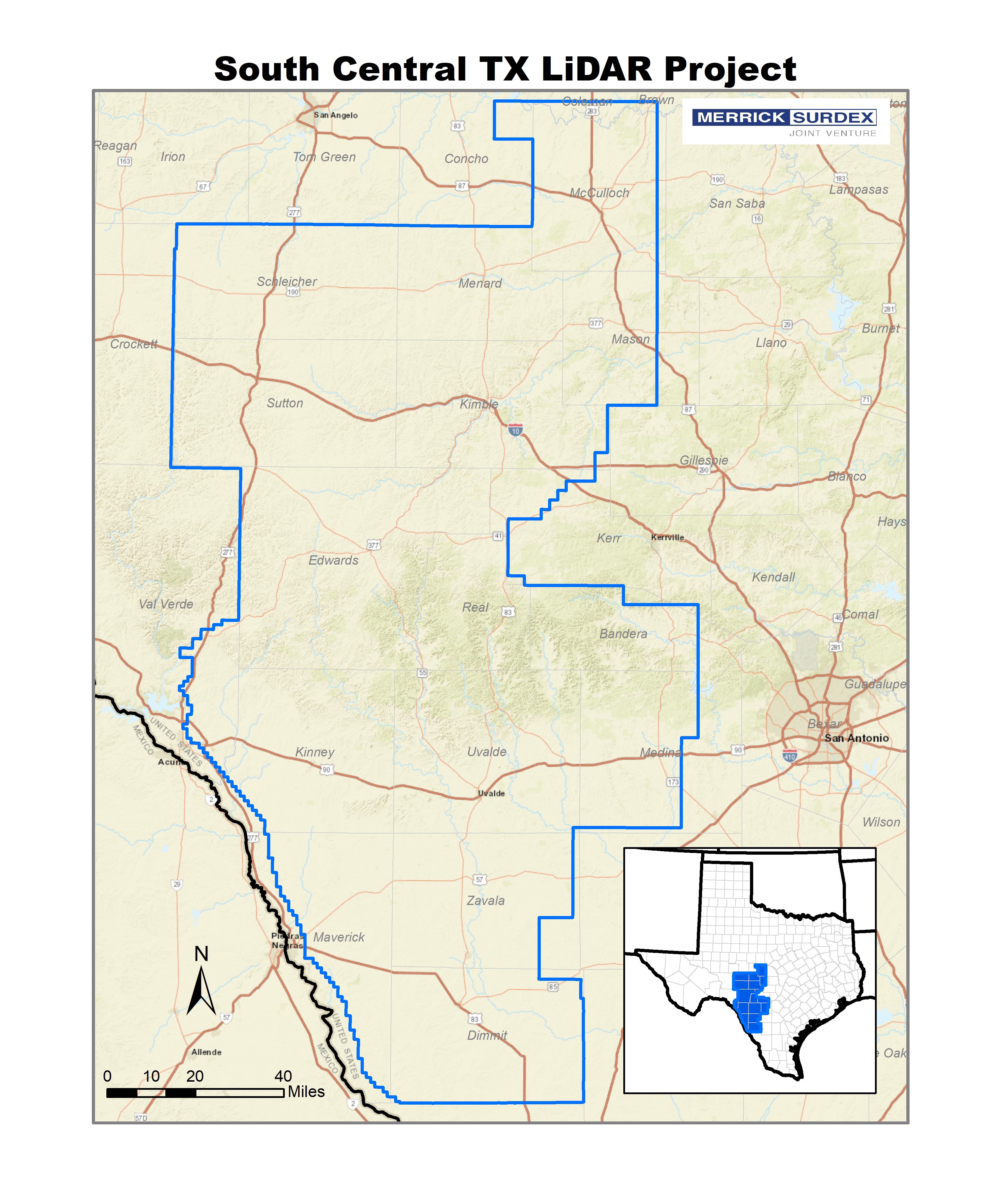
South Central TX LiDAR Project

Enhanced Hydrology in Texas LiDAR by Merrick-Surdex JV Critical to Risk Mapping

In 2017 the USGS selected the Merrick-Surdex Joint Venture to collect and process LiDAR data of approximately 17,950 square miles in Southwest Texas. One of the funding partners to the project, FEMA, required new elevation data in order to reclassify older hydrographic features to improve flood map accuracy. The data will be used to assist in risk management of potential flooding areas, due to significant shifts in precipitation over the past decade.
The State of Texas has experienced a nearly decade-long drought; in February 2018, nearly 90% of the state was under a drought warning. Within one year, these conditions shifted dramatically – in 2018, rains had been so persistent and heavy that by October less than 5% of the state was under a drought warning. This sudden increase in such a large volume of water has created a scenario with a notable risk of overflowing and flooding of once-dry riverbeds. The state consequently switched from a drought status to a situation of potential widespread flooding, with all the subsequent possibility of damage. FEMA and Texas Water Development Board (TWDB) anticipating the effects of such a situation, initiated a project with the USGS to obtain data to manage this new condition.

The Joint Venture’s effort towards the collection of hydrographic features was designed to exceed the USGS project specifications and to ensure map accuracy so that hydrological events could be monitored with confidence. Production staff invested a higher than normal amount of time and effort to identify stream banks that have been undefined by water for years due to drought. According to version 1.3 of the USGS LiDAR Base Specification, the minimum width for the collection of inland streams and rivers is 100 feet however due to the low water levels there are multiple instances where these features were as narrow as 10-15 feet and ordinarily would not have been collected. In several cases, widths varied considerably along the same stream, and had the only the portions of rivers/streams greater than 100 feet been collected, it would have resulted in disconnected networks of drainage. Additionally, several lakes/ponds would have been omitted for not meeting the minimum two-acre size criteria. These conflicts of elevation in the hydro-flattened Digital Elevation Models (DEMs) would have limited the data usefulness to all agencies. The process chosen will ensure map accuracy and hydrological events could be monitored with confidence.

Read More

State Spotlight: Utah

Matt Peters
Automated Geographic Reference Center Director

Interviewed by Tim Bohn

For Utah GIO Matt Peters, successful statewide GIS coordination is all about communicating a vision and helping everyone speak the same language. It takes strategy and finesse, he said, to “make sure the tide raises all boats.”

Helping stakeholders embrace that vision means focusing on the data rather than getting caught up in the technology. “Data is the foundation and is fundamental to analysis,” he said. “For example, address ranges affect geocoding, so if the quality is not there, nothing moves forward. Today … improved, polished data [is available] for use in web services. Point-in-polygon matching is also more accurate.”


Read More

Licensed Commercial Imagery as an Enterprise Resource: The Terms Matter!

“Let’s get everyone working on the same map!”

This is a compelling, succinct goal that speaks to the value of taking an ‘enterprise-wide approach’ to acquiring GIS data resources, including high-resolution aerial photography. It’s a safe bet that the “on the same map” argument was part of the advocacy efforts of states that have successfully sought and received support to build public domain imagery programs.

“On the same map” is also a very relevant objective for states or regions (or even nations) considering a licensed imagery purchase from the emerging market of commercial aerial products. While public domain programs are a great goal, in recent years there has been more growth in the adoption of statewide licensed programs, perhaps because of lower, but not perfectly comparable costs. In a mature geospatial world, imagery is probably an open, public domain resource, but if you’re not there yet, a licensed product could be a good fit.

Read More

Senate Passes GIS Day Resolution Following Successful Passage of Geospatial Data Act

Senator Orrin Hatch (R-UT) and Senator Mark Warner (D-VA) led a Senate resolution to designate November 15, 2018 as “National GIS Day.” Senators Baldwin (D-WI), Blumenthal (D-CT), Capito (R-WV), Hassan (D-NH), Inhofe (R-OK), and Wyden (D-OR) joined Hatch and Warner in submitting the resolution.

“The Senate designates November 15, 2018, as ‘National GIS Day’; encourages users of Geographic Information System technology … [including] educators, students, and innovators to continue to employ GIS to learn and explore, to analyze and address societal challenges; and to drive economic growth for the betterment of the people of the United States and individuals around the world.” the three-page resolution concludes.

This recognition by the Senate punctuates the passage of the Geospatial Data Act, included as a component in H.R. 302, the FAA Reauthorization Act signed into law last month.

Read More

State Spotlight: Florida

Ekaterina Fitos
State Geospatial Information Officer

Interviewed by Tim Bohn

Florida is a big, complex state, said GIO Ekaterina Fitos, and the key to coordinating GIS across the state is through a collaborative enterprise approach with GIS focused work groups and engagement of stakeholders.

Just ten months into the job as Florida’s first GIO, Fitos said she is continuing to assess Florida’s statewide spatial data infrastructure. There are plenty of success stories, she said, citing the Florida Department of Environmental Protection’s mobile applications one of which assists with notifying the public about state park closures during disasters (Figure 1), the GATOR web application by the Florida Division of Emergency Management (FDEM) (Figure 2), and an online system to monitor sea turtles developed by the Florida Fish and Wildlife Commission (FWC) (Figure 3) .


Read More

Carpe Geo: Becoming a Great GIS Leader

How can you grow into the GIS leader you aspire to be? How can you work better with others? How can you get the most satisfaction out of your GIS career? These are questions that AppGeo believes can be answered through thoughtful application of Carpe Geo principles. Carpe Geo is about seizing the opportunities to do great things with GIS.

Those of you who attended the 2017 NSGIC Annual Conference in Providence, RI may remember hearing Bill Johnson’s Carpe Geo & Parvum Momentum presentation, where he first introduced us to these ideas. Since then, Bill has joined the AppGeo team and at this year’s NSGIC Annual he followed up with Carpe Geo, Part Deux, which explored how the principles of Carpe Geo can help you become a better GIS leader.

Becoming a great GIS leader doesn’t happen overnight. To better understand how one grows and metamorphosizes into that role, consider three lenses or models that can help you understand the growth path.

Read More

State Spotlight: Minnesota

Dan Ross
GIO, Chief Business Technical Officer and CIO, Pollution Control

Interviewed by Tim Bohn and Tim Donze

Minnesota GIO Dan Ross has spent 23 years in state government if you include the three years he spent as a system administrator and adjunct professor teaching GIS at St. Cloud State. In that time, he has seen GIS go from highly collaborative to falling off, and now in resurgence with both data sharing and a standards development.

Five years ago, said Ross, there were no statewide parcels, centerlines with address ranges, addresses or standards to support those data layers. The state “is in much better shape now,” he said. “The community has come together and renewed the collaboration.”


Read More

State Geospatial Policy Organization Lauds “Geospatial Data Act” Language Included in FAA Reauthorization Bill

Participants at the National States Geographic Information Council (NSGIC) Annual Conference cheered at the news that the Federal Aviation Administration (FAA) reauthorization bill passed the Senate this morning.

The legislation contains provisions critical to building the national spatial data infrastructure by establishing a clear vision, assigning responsibility, providing authority and ensuring oversight of federal activities by Congress. The bill includes language previously winding its way through both houses as a standalone bill called the Geospatial Data Act.

“This is a major win for the entire geospatial community. We thank and commend our nation’s lawmakers for enacting this meaningful legislation,” said Dan Ross, geospatial information chief for the state of Minnesota and NSGIC president. “NSGIC members coordinate geospatial policy, technologies, and services across our states. We have the unique perspective of seeing across states - and, together, across the nation - to evaluate the substantial and significant unmet needs stemming from a failure to harness and coordinate efforts. ”

Read More