|
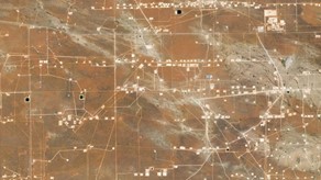
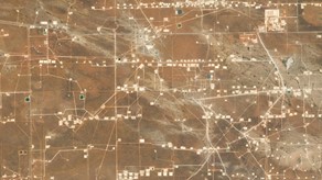
Sponsor Spotlight: PlanetBy Planet I November 16, 2021 Streamlining Operations in the New Normal: Leveraging Satellite Data for Conservation and Compliance The COVID-19 pandemic has sparked a “New Normal” for State, Local, and Tribal governments across the U.S. that is likely to last. This “New Normal” of more limited resources, uncertainty, and distributed teams presents unprecedented challenges for land use monitoring as the demand for water resources, agricultural yields, grazing land, and urban expansion continues to grow. It’s harder to maintain a reliable and updated view of what’s happening on the ground as field operations become slower and more expensive. More advanced, complete datasets are needed to break down silos of information and increase efficiency. Planet delivers near-daily, high-resolution satellite imagery, reliably processed and delivered within hours of capture. Organizations across the country are using Planet data within their existing workflows to grow and meet these challenges head-on. Monitoring Compliance Across Leased LandsThe New Mexico State Land Office (NMSLO) is mandated to preserve 9 million acres of public lands while supporting economic development. However the vast, rugged terrain makes it slow and difficult to inspect leased land, and existing data sources are expensive and equally slow to deliver real-time visibility over their territories. The high-frequency, broad-area coverage of Planet’s satellite imagery helps NMSLO to achieve greater compliance of leased land and proactively identify illegal activity. Within the first 12 months of using Planet imagery, NMSLO discovered 53 trespasses and $2.7 million in back payments to be dispersed to New Mexico public schools, hospitals, and other institutions key to supporting the health and safety of their communities. They discovered 22 trespasses resulting in new leases that generated $800,000 in revenue.
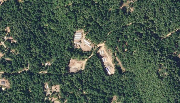
Enforcing Cannabis OrdinancesFollowing the legalization of cannabis in California, Humboldt County needed a cost-effective way to monitor permitted farms and illegal cultivation. Previously, Humboldt County had a complaint-based, reactionary enforcement model that was resource-intensive and insufficient for deterring violations. The remote and densely forested landscape of Humboldt posed considerable challenges in terms of access and visibility. Enforcement officials lacked a centralized, macro-level view of where illegal cultivation was concentrated and how best to reach those areas, resulting in high personnel costs, vehicle maintenance costs, and long drive times. Humboldt County found that Planet was the only provider that offered imagery that could scale across the entire county (around 10,000 km2) at the sufficient spatial resolution and monthly revisit needed to accurately monitor for cannabis cultivation signatures and expansions. The county went from issuing around 100 citations in a year to up to 700 infractions, collecting $2 million in additional county revenue, and minimizing environmental impacts from clearing and waste disposal.
Balancing Conservation and Economic Growth The Mississippi Department of Marine Resources has found a more efficient way to balance economic growth while protecting the diverse ecosystems found in the wetlands and bayous of the Gulf Coast. Using near-daily satellite imagery and Planet’s extensive imagery archive, officials were able to confirm that the disappearance of a protected submerged aquatic habitat (SAV) over a permitted area was due to natural causes, and not from the work of the company that held the permit to develop the land. Within just 24 hours of reporting that the habitat was gone, officials were able to remotely confirm the report without ever having to send people out into the field. You Can’t Measure What You Can’t See Planet’s daily information feeds are helping governments define new methods to monitor resources and account for environmental assets, which is foundational for protecting the health and prosperity of local communities. Planet is driven by a mission to make change visible, accessible, and actionable. With an extensive catalogue of archive imagery, Planet enables users to go back through time and analyze historical change. Planet’s cloud-native platform and extensive partner network enables users to simply and effectively derive unique value from satellite imagery on a daily basis. The Planet user network doesn’t end here. Hear more from the State of Alaska and watch the NSGIC Planet Fireside Chat on demand.
|