Sep
24
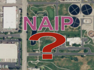
Aerial photography is an incredibly valuable resource to a broad set of uses in the business, government, and research sectors. An aerial view, whether from a satellite or an airborne camera, provides excellent situational awareness, for among other things:
- Responding to a crisis - like 911 centers coordinating response to everyday emergencies or coordination for wildfires, flooding, and hurricanes
- Informing real-time consumer decisions and organizational operations - everything from tourism to package delivery
- Planning for the future - like siting and designing new developments and transportation projects
- Building map-based datasets of infrastructure and natural assets - to better inventory and analyze how urban and natural systems perform
- Providing a historical record over time - for dispute resolution and understanding development and change patterns
While it is expensive to acquire, it is practically indisputable that the immense value of accessible, up-to-date, and high-resolution aerial photography dwarfs the costs to capture and distribute the imagery.
So what's the problem? In a nutshell, there's no national model in place to efficiently fund, collect, and provide access to this highly desirable resource, that - unlike most types of products - actually becomes more valuable the more it is put to use.
 3DEP for the Nation addresses the need for high-quality topographic data and three-dimensional representations of the nation’s natural and constructed features. Believing 3DEP coverage across the US can be most effectively achieved by establishing plans for each individual state and territory, NSGIC is leveraging its strong working relationships with state geospatial information officers and coordinators to develop these plans.
 The Department of Technology and Information (DTI) nominated Kim Cloud for the Delaware Award for Excellence and Commitment in State Service because of her outstanding state service and ongoing commitment to DTI. Kim has worked at DTI since July 19, 2004, and has spent her tenure as a software engineer for the Application Delivery team. Kim’s passion is working with geospatial data (location-based data) and GIS software and tools, i.e. FirstMap, which is a GIS solution that provides a centralized repository and enables users to maintain and analyze spatial data.