

Sponsor Spotlight: DATAMARKMultiple Partners for a Single System: Meeting Multiple Business Needs in a Collaborative Environment By Sandy Dyre, ENP, DATAMARK, Michael Baker International | May 17, 2021 The technical and organizational complexity of GIS for Next Generation 9-1-1 is just one of the many considerations for decision makers when determining an NG9-1-1 solution. Whether the deployment will be PSAP-by-PSAP, County-by-County, or as a regional or statewide implementation, one common goal is the seamless connectivity of data to support the 9-1-1 caller. To prepare for this level of interoperability, 9-1-1 and GIS decision makers have the added challenge of how to best meet NG9-1-1 needs and requirements while still recognizing the autonomy of the many data providers that have the added responsibility of supporting the business needs of their individual communities. The complexity of a GIS ecosystem can grow exponentially when one considers the scope of the various deployment “patterns” that are possible to meet the data validation, aggregation, and provisioning requirements for multi-jurisdictional entities. It is quite common for adjoining jurisdictions to have completely different GIS data that has widely varying data quality and is updated on similar varying update cycles. The management challenge grows as each adjoining jurisdiction is added to the larger collaboration effort. Scalable solutions that allow for iterative validation and aggregation from multiple sources into a single database help to ensure the capability to support the interoperable needs of NG9-1-1. The ability to: 
ensures that the needs of the entire data ecosystem are being met. Centralized but federated management and ongoing validation of the aggregated GIS dataset streamlines its use across public safety platforms, including legacy 9-1-1, NG9-1-1, Computer-Aided Dispatch (CAD), and others. Multiple partners, multiple needs can be met with a single system allowing maximum use and visibility of the data to expose concerns before its use in an emergency. 
DATAMARK VEP was designed to support a range of deployment patterns so that it could scale from the single PSAP to multi-County and upward to regional and statewide. VEP Validator and Editor subscriptions include GIS data validation, editing, and provisioning functions and features. Implementation of VEP supports provisioning to your native GIS schema and to the National Emergency Number Association (NENA) NG9-1-1 GIS schema. VEP is platform-agnostic and capable of provisioning GIS data to meet varying system needs including NG9-1-1, addressing, transportation, and other community data needs. VEP Validator and Editor can be deployed to accommodate the specific provisioning requirements of a single PSAP, a regional approach or a statewide collective. VEP Validator and Editor can be deployed with VEP Aggregator to provide regional or statewide GIS stakeholders VEP’s validation and provisioning features for managing multi-jurisdiction implementations. Clients who currently use VEP to manage local GIS data can efficiently and easily submit their GIS into the aggregated dataset. 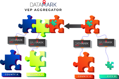
VEP Aggregator does not require the purchase of additional software or tools and includes VEP’s validation and provisioning features. Consolidating and synchronizing local and regional databases is a seamless process using Aggregator from the VEP system dashboard. As local jurisdictions submit data into the aggregated dataset, regional GIS administrators supporting the database can use Aggregator to perform to the following tasks:
When deployed in combination, VEP Validator, Editor and Aggregator provide an end-to-end solution for meeting the complex requirements of multi-jurisdictional GIS data provisioning for NG9-1-1. |