|

How to Make the Most of the NSGIC Emerging Partner Program - A Perspective from makepath
January 10, 2023
Is the NSGIC Emerging Partner program right for you? If you are a new company considering whether to partner with NSGIC, this blog post was written for you.
We are makepath, a geospatial data science company focused on Open Source GIS, Open Source Machine Learning, and Visualizations. We were founded in Austin Texas in February of 2020. We joined NSGIC as an Emerging Partner in mid-2020.
The bottom line is we have found our partnership with NSGIC to be a great long-term investment.
It has taken consistent follow-through and conscious engagement, and almost three years later, we are now a Bronze Level Business Partner and have many active partnerships with both individual states and with private business partners.
In this post we will share what has worked for us.
2022 State Election Director Report Available Now
October 19, 2022
As part of its final-year deliverables, NSGIC’s Geo-Enabled Elections project today released the 2022 State Election Director Report, documenting progress in the use of GIS technology in elections across the United States since the project’s inception in 2017.
In the report, the authors note that a remarkable 86% of U.S. states and territories have participated in the Geo-Enabled Elections project over the course of the project.
Election directors from 28 states and territories were interviewed or surveyed for the report, providing details on advances in the integration of GIS in elections. Examples include a greater use of audits to verify voter lists, and a significant increase in real-time updates of voter addresses.
Addresses for the Nation - Pathways from Restricted Data to Open Data
August 18, 2022
Accurate and up-to-date addresses and their locations are critical to transportation safety and are a vital part of Next Generation 9-1-1. They are also essential for a broad range of government services, including mail delivery, permitting, and school siting. In addition, the data can help enable critical applications including public health tracking and disease vector control, natural disaster response, transportation planning, construction/improvements notification, and provision of affordable housing. The National Address Database (NAD) is a unified collection of authoritative address points integrated from partners across the country. In most cases, the data is collected and maintained at the tribal or local governments, the data authorities, and aggregated to the state level before submission to the NAD.
Document Released: "GIS is Critical for Next Generation 9-1-1"
July 26, 2022
Recently, members of URISA and the NSGIC NG9-1-1 Working Group came together to collaboratively author an informational document for policy makers and elected officials not familiar Next Generation 9-1-1. "GIS is Critical for Next Generation 9-1-1" is a fact sheet that communicates how 9-1-1 works, how Next Generation 9-1-1 is different, and the important role of GIS in Next Generation 9-1-1. Rather than answering all of the questions, GIS is Critical for Next Generation 9-1-1 opens the door to continued conversation about Next Generation 9-1-1 GIS efforts in a particular state, region, or locale.
Six Months Left for Geo-Enabled Elections Project; 2021 Report Released
June 30, 2022
With six months remaining for the Geo-Enabled Elections project, key stakeholders are looking ahead to what’s next while also recognizing accomplishments to date.
Currently, the project team is finalizing the 2022 State Election Director Report, documenting progress in the use of GIS technology in elections across the country since the project’s inception in 2017. Targeted for release in the fall, the report will review advances in voter address management and auditing, states’ access to technology and systems capable of using GIS location information, collaboration with state GIOs, and more.
Geo-Enabled Elections in the News – Data, Progress Across the U.S.; 2022 Focus
May 31, 2022
The Geo-Enabled Elections project was featured in the news this spring, shining a light on the work to make elections more accurate and efficient using GIS. The topic is timely, given that new voting districts are being rolled out across the country, followed by a string of local and national elections.
Jill Clark and Joseph Kerski’s excellent blog, centered on public domain spatial data, featured a discussion on how the data used to conduct elections can be improved using data culled from other sources. Kerski, a geographer with a distinguished career in GIS and education, serves as education manager at Esri. The blog, Spatial Reserves, continues the conversation started in the book by Clark and Kerski, The GIS Guide to Public Domain Data, and aims to provide GIS practitioners and instructors with the essential skills to find, acquire, format, and analyze public domain spatial data.
GISCI Announces GISCI Endorsement Designation
March 7, 2022
The GIS Certification Institute (GISCI) has created the GISCI Endorsement Designation Program to help increase the value of GISP Certification for our primary stakeholders, and to help facilitate the growth of the GISP Program within the geospatial community. The GISCI will grant the GISCI Endorsement Designation to organizations that the GISCI deems to be supportive of GIS Professionals and the GISP Certification process by way of internal activities, programs, and policies. The designation is not only a commitment to GISP Certification for staff, but also to upholding the ideals of the GIS Certification Institute.
Progress, Technology, Reviewed at Third Annual Elections GeoSummit; Sessions Now Available Online
March 4, 2022
The third annual Elections GeoSummit was held on Thursday, December 9, 2021, with 220 elections administrators and GIS professionals in attendance. The day’s focus was on the progress that’s been made around the country when it comes to election modernization.
Neal Kelley, registrar of voters for Orange County, California, kicked off the meeting with his appreciated keynote, which can be viewed here. Among the many benefits of using GIS in elections realized in his county, he highlighted the experience of voters:
NSGIC Releases Findings from 2021 Geospatial Maturity Assessment
December 15, 2021
The National States Geographic Information Council (NSGIC) has released its 2021 comprehensive Geospatial Maturity Assessment (GMA) report, providing NSGIC members and partners with a summary of geospatial initiatives, capabilities, and issues within and across state governments.
Launched in 2009 and conducted biennially to document geospatial development practices and uses, the GMA has continued to provide a snapshot of each state’s geospatial maturity. Inspired by the National Spatial Data Infrastructure theme grading undertaken by the Coalition of Geospatial Organizations (of which NSGIC is a founding member), an entirely new process was developed for the 2019 GMA. Nine-grade “report cards” were produced for individual state spatial data infrastructures and state geospatial coordination, in addition to overall theme and topical analysis.
Sponsor Spotlight: Planet
By Planet | November 16, 2021
The COVID-19 pandemic has sparked a “New Normal” for State, Local, and Tribal governments across the U.S. that is likely to last. This “New Normal” of more limited resources, uncertainty, and distributed teams presents unprecedented challenges for land use monitoring as the demand for water resources, agricultural yields, grazing land, and urban expansion continues to grow. It’s harder to maintain a reliable and updated view of what’s happening on the ground as field operations become slower and more expensive.
More advanced, complete datasets are needed to break down silos of information and increase efficiency. Planet delivers near-daily, high-resolution satellite imagery, reliably processed and delivered within hours of capture. Organizations across the country are using Planet data within their existing workflows to grow and meet these challenges head-on.
Sponsor Spotlight: GeoComm
By GeoComm | October 12, 2021
With GIS data playing a key role across E9-1-1, Next Generation 9-1-1(NG9-1-1), Emergency Communication Center (ECC) and responder tactical mapping systems and applications, and now indoor and vertical 9-1-1 caller location, it has become an imperative for 9-1-1 to implement Public Safety Grade GIS data. These mission critical life safety systems and applications rely on GIS data to drive emergency response - helping to save lives and protect property. This GIS data must be highly accurate, highly secure, highly available, up-to-date, and commonly accessible to all mission critical life safety applications across 9-1-1 and public safety organizations.
States Continue to Spur Growth of National Address Database, Bringing in New Partners & Making Strong Case for Multi-Use Data
By Molly Schar | October 4, 2021
At a pair of sessions presented at the annual conference of the National States Geographic Information Council (NSGIC) on Sept. 22 in Dallas, representatives from the US Department of Transportation delivered the latest update in the efforts to build a robust National Address Database to meet the needs for open and authoritative data across government and industry.
Steve Lewis, Geospatial Information Officer for the USDOT, provided a live demonstration of an innovative new visualization tool for the National Address Database (NAD), developed in partnership with geospatial technology giant Esri. This “sneak peek” offered a glimpse of the future of the NAD, which had been previously available only in bulk download.
NSGIC Announces New Board Members; Arizona’s Jenna Leveille Takes Over as President
By Molly Schar | September 30, 2021
National States Geographic Information Council (NSGIC) announces the election of new members to its Board of Directors, as well as the full slate of officers and board members for the 2020 - 2021 term.
Jenna Leveille (AZ) makes the move from President-Elect to assume the presidency of NSGIC, taking the reins from Frank Winters (NY). Jenna is Arizona’s Deputy State Cartographer, where she coordinates, provides leadership, facilitates the Arizona Geographic Information Council (AGIC) and coordinates statewide GIS initiatives. Her contributions to AGIC include providing administrative support, facilitating all AGIC Council and Committee meetings and activities, serving as a Co-chair to four AGIC technical committees and managing AZGeo, Arizona’s State Geospatial Data Portal. Notable activities include:
Sponsor Spotlight: Ecopia
By Ecopia | September 24, 2021
The emergence of very high-resolution (VHR) commercial imagery products, both satellite and aerial, has led to an increased demand for high-accuracy derivative data.
Historically, derivative products created at a countrywide scale were produced to a 30-meter, or at best, 10-meter resolution. Ecopia has shifted the paradigm of data extraction by leveraging the power of artificial intelligence (AI) and readily available high-resolution imagery. With access to both VHR aerial and satellite imagery through our network of imagery partners, Ecopia has established a streamlined workflow to produce high-resolution vector data across the globe.
Ecopia recently announced a partnership with Hexagon Geosystems to create a high-precision 3D vector map of the entire United States derived from 6” and 12” resolution stereo aerial imagery. The resulting map, 3D Nationwide Landcover, will offer a highly accurate digital representation of the entire country, and all with the accuracy of a GIS professional. Ecopia’s 3D Nationwide Landcover will be made readily available as an off-the-shelf product, offering highly accurate foundational data for critical decision-making applications including flood modelling & stormwater analysis, insurance risk assessment, and transportation engineering.
2021 Geospatial Excellence Awards Announced
By Molly Schar | September 22, 2021
National States Geographic Information Council (NSGIC) President Frank Winters (NY) led a celebration of the 2021 Geospatial Excellence Awards during a reception held this evening at the organization's Annual Conference.
2021 Geospatial Excellence Awards:
- Catalyst Awards: for extraordinary effort and/or results in getting things done:
- Nebraska's Office of the CIO - GIO Team
- State of North Carolina Next Generation 9-1-1 Project Team
- The Wisconsin Department of Health, Bureau of Information Technology Services, GIS Team
- Indiana Geographic Information Office (GIO)
- Minnesota Geospatial Advisory Council's 3D Geomatics Committee (3DGeo)
- Innovator Award: for creatively advancing geospatial technical capabilities or problem solving
- Nebraska's Office of the CIO - GIO Team
- State of Minnesota Maps Community of Practice
- Adam Oestreich
- NJ Department of Environmental Protection: Bureau of Nuclear Engineering and Bureau of GIS
Sponsor Spotlight: Hexagon
By Hexagon | August 11, 2021
The HxGN Content Program, Hexagon's aerial data program, offers the largest library of high-resolution multispectral aerial imagery and elevation data of the United States. For state and local governments, Hexagon provides a flexible licensing model that enables stakeholders to tailor data collection to their exact specifications.
Trevis Gigliotti, Director, Technical Content Solutions at Hexagon, explains how state and local governments can benefit by partnering with Hexagon.
The geospatial imagery space has evolved significantly over the last decade. What are some notable trends we're seeing today?
There are two significant trends that we're experiencing. First, the availability and overall commoditization of imagery data. We've all searched for our house or landmark on our device—it's pretty common practice. Imagery is used in so many applications other than just traditional GIS markets. From planning a hike or mountain biking routes to filing insurance claims, imagery shows up in many new environments.
State GIS Projects Recognized with Esri’s Special Achievement in GIS Awards
August 4, 2021
It was terrific to see so much exciting state GIS work highlighted during the Esri Users Conference this year! Of special note were Special Achievement in GIS (SAG) Award Winners among NSGIC's membership:
NSGIC Names Cy Smith to New Policy Role
August 2, 2021
After serving many years as a NSGIC state representative, board member, and board president, Cy Smith has joined NSGIC’s staff team in the newly-created role of Policy Director. In this position, Smith will work with NSGIC leadership to develop, promote, and coordinate strategies that advance states’ geospatial interests linked to federal programs, congressional actions, and related initiatives. The new appointment coincides with Smith’s retirement from state government service in Oregon on Nov. 12, 2021.
“Cy has been an extraordinary contributor to NSGIC and the entire geospatial ecosystem for nearly three decades,” said NSGIC Executive Director Molly Schar. “We are very fortunate to welcome him in this new strategic role as efforts continue to evolve in support of a robust National Spatial Data Infrastructure.”
Sponsor Spotlight: NV5 Geospatial
By NV5 Geospatial | June 25, 2021
With the recent acquisition of Geodynamics LLC, NV5 Geospatial has built one of the most comprehensive suites of solutions for geospatial surveys of deep water and near-shore environments. The combination brings together complementary, advanced technologies – Geodynamics’ full-ocean depth sonar-based hydrographic and geophysical surveying with NV5 Geospatial’s topographic and bathymetric capabilities – to deliver detailed insights for a variety of applications, including coastal management, flood monitoring, ecosystem protection, research, and more.
“This acquisition was a natural evolution toward our common goal of delivering valuable geospatial insights to our clients,” said Kurt Allen, vice president, Federal Vertical for NV5 Geospatial, North America’s largest and most comprehensive geospatial firm. “Our decades of combined experience and expertise using the most sophisticated technology for data acquisition and analysis will enable us to meet the most demanding client requirements.”
Sponsor Spotlight: DATAMARK
By Sandy Dyre, ENP, DATAMARK, Michael Baker International | May 17, 2021
The technical and organizational complexity of GIS for Next Generation 9-1-1 is just one of the many considerations for decision makers when determining an NG9-1-1 solution. Whether the deployment will be PSAP-by-PSAP, County-by-County, or as a regional or statewide implementation, one common goal is the seamless connectivity of data to support the 9-1-1 caller. To prepare for this level of interoperability, 9-1-1 and GIS decision makers have the added challenge of how to best meet NG9-1-1 needs and requirements while still recognizing the autonomy of the many data providers that have the added responsibility of supporting the business needs of their individual communities.
The complexity of a GIS ecosystem can grow exponentially when one considers the scope of the various deployment “patterns” that are possible to meet the data validation, aggregation, and provisioning requirements for multi-jurisdictional entities. It is quite common for adjoining jurisdictions to have completely different GIS data that has widely varying data quality and is updated on similar varying update cycles. The management challenge grows as each adjoining jurisdiction is added to the larger collaboration effort.
Sponsor Spotlight: TeachMeGIS
By TeachMeGIS | April 13, 2021
‘Collaboration allows us to know more than we are capable of knowing ourselves.’ –Paul Solarz

It’s a fantastic thing to see figurative lightbulbs go on across the room at NSGIC meetings and in the socials as the top GIS professionals from every state come together to share knowledge and ideas.
At TeachMeGIS, we see this happen on a smaller scale nearly every day during our GIS classes. The instructor demonstrates a spatial join tool, and someone with point data says, “Hey you, you with the polygon data, let’s try this! I’ve needed this for years!”
What better way to increase collaboration within and between organizations than bringing people into the same room (in person or virtually), bringing them all up to the same level of geospatial knowledge, and encouraging them to talk and share their ideas and expertise. This is true of state C-Level executives who need to understand the robust GIS database that helps run their state, as well as engineers, planners, biologists, PSAP GIS staff, and others at all levels who need to access spatial data.
Prepare: Redistricting Approaches! (and Observations)
By Bert Granberg | March 26, 2021
Really big decisions are about to be made in your state. Say what you want about the redistricting process, but the fact is, somebody’s going to have to put the results to work to run our future elections. And with that in mind, I've dusted off my list of observations from 10 years back, about what makes for the best set of boundaries from a standpoint of state election directors, local elections clerks, and GIOs and others supporting them with GIS.
The observations I’m sharing are based on first-hand experience in 2011-12, watching the redistricting process from a safe distance, while preparing to support the use of the new districts. During this period, Utah was one of the first states to integrate GIS-based address locations, voting unit polygons (precincts and sub/splits), aerial photography, and parcel base maps into its statewide elections management system. In addition, the Utah Legislature deployed a 'build-your-own' redistricting plan webmap, another first. As a result, GIS was front and center to the redistricting stage, exposing new users to its power and broadening their appreciation for mapping technology and authoritative data.
Transportation Best Practices: On the Road to Success
NSGIC issued Best Practices for State Geospatial Maturity: Transportation today. In addition to being the backbone of our public safety and emergency management infrastructure systems, transportation data have achieved near-ubiquity in the hands of smart device users.
A viable transportation network, particularly a roadway network, is of paramount importance in our society, having the primary purposes of connecting people and places and allowing the movement of people, goods, and vehicles safely and efficiently. Transportation data allow us to spatially model and depict the network for the purposes of planning, asset management, navigation, and routing.
Elevation-Derived Hydrography for the 3D National Hydrography Dataset (EDH for 3DNHD) Project Opportunities
By Lynda Wayne | March 8, 2021
Interested in improving your hydrography data using lidar and other elevation data? Then don’t miss any of the following EDH for 3DNHD project opportunities. Each is open to all and NSGIC State Representatives are asked to forward this information to their state NHD/WBD stewards and others with interests in EDH. Non-members will be required to register with the NSGIC website.
Sponsor Spotlight: Equip Your GIS Analysts with Easily Scalable Tools
By makepath | March 5, 2021
In this post, makepath will spotlight two tools that are great because they scale well, especially as the scope of a project grows. Scalability is gold in the GIS world.
Xarray-Spatial
Xarray-Spatial is a spatial processing toolbox for GIS professionals. It is an open source GIS Python library for raster analysis that is easy to install and extend to apply to different GIS scenarios and use cases.
Hennepin County and Mapping Prejudice win Freedom of Information Award
By Will Craig | March 2, 2021
The Minnesota Coalition on Government Information gives a Freedom of Information Award annually. Their focus is on government transparency and efforts to unearth data that make a positive difference. Innovative use of technology is encouraged and rewarded.
The 2021 award will be given to a partnership between Hennepin County and the Mapping Prejudice project for mapping racial covenants recorded between 1910 and 1955. The county scanned and provided all their deeds. It also provided digital cadastral maps to support mapping. The project used optical character recognition (OCR) and thousands of volunteers to find and transcribe racial covenants, then map with GIS.
The product is an animated map showing the spread of racial covenants. The impact has included increased public awareness of the past prejudice and changes in state and local laws to confront that past. Local and national media have reported this story. Jim Crow of the North, developed by Twin Cities public television, has been picked up PBS and soon will be available nationally.
The FOI award will be given on March 15, 2021 at 7:00pm CST. The event is free and open to the public, but registration is required. Click here to register.
NSGIC Releases New Guidance for States to Strengthen NG9-1-1 Efforts
NSGIC has published a new guide on Best Practices for State Geospatial Maturity: Next Generation 9-1-1 (NG9-1-1). NG9-1-1 has been a priority for NSGIC for years. This best practices document is a collection of insights from states further along in adoption and planning of NG9-1-1 efforts.
Next Generation 9-1-1 is a gamechanger for the 9-1-1 community. It utilizes GIS technology to deliver every 9-1-1 call - mobile, VOIP, and landline alike - to 9-1-1 public safety answering point (PSAP) centers with precise geographic coordinates.
With the implementation of NG9-1-1, it is possible for the 9-1-1 network to process text messages, photos, and videos in addition to voice through a faster and more resilient system. NG9-1-1 will also support PSAPs in cases of call overload and natural disasters, and jurisdictional issues.
What Makes for Strong Statewide GIS Coordination? High Performing States Weigh In
Strong statewide GIS coordination is good government. It:
- Reduces duplication of efforts
- Builds and maintains foundational data layers
- Ensures access to public data
- Leverages economies of scale for products, software, and services
- Augments the knowledge base of professionals in the field
- Establishes standards and best practices through collaborative processes
In short, it supports efficiency, integration, and smart decision-making.
NSGIC Announces New Board Members; New York State’s Frank Winters takes over as President
September, 24, 2020, New Orleans, LA - National States Geographic Information Council (NSGIC) announces the appointment of five new members to its Board of Directors, as well as the full slate of officers and board members for the 2020 - 2021 term.
Frank Winters (NY) makes the move from President-Elect to assume the presidency of NSGIC, taking the reins from Karen Rogers (WY). Frank is the Executive Director of the New York State Geospatial Advisory Committee. Frank has a Master of Science in Geography from the University of Idaho and has been involved with GIS in New York State government for 29 years.
2020 Geospatial Excellence Awards
Eight Awards Presented at NSGIC Virtual Annual Conference
National States Geographic Information Council (NSGIC) President Karen Rogers (WY) led a celebration of the 2020 Geospatial Excellence Awards during an online reception held this evening in conjunction with the organization’s Virtual Annual Conference.
“The awards are testimony to the dedicated professionals doing amazing work in states across the country,” says NSGIC President Karen Rogers. “Every recipient is providing value to their GIS community or tools to inform decision makers, which is what it’s all about. The benefits NSGIC members bring to their constituents and leadership cannot be understated, not to mention pushing the envelope of innovation when it comes to location intelligence and data science. It fills me with pride to know how the technology we care so deeply about makes such a difference.”
Partner Spotlight: GeoComm
By GeoComm | September, 2020
Today public safety GIS data and location information is disparate, inconsistent, and expanding. Public Safety Location Intelligence from GeoComm provides a new way to get the right location information, on the right map, for the right people, at the right time, in order to respond to emergency calls faster.
In an emergency every second counts and GIS data has never played a more important role in mission critical public safety. Today when a 9-1-1 call is placed, a patchwork of technology provides limited additional data about the location on different screens or in different applications, hurting our ability to utilize all of the valuable location content available to support emergency response.
Partner Spotlight: Fugro
Shining a Light on Change with Recurring Lidar Programs
By Keith Owens and Lauren Hunter of Fugro / August 18, 2020
Our landscape is in a state of constant change. Cities and towns are expanding at a rapid pace, while natural disasters are rearranging rivers, eroding shorelines, and crumbling infrastructure. To effectively manage change, we need geospatial data that is both fit-for-purpose and recurrent, as well as visualization tools to communicate this information to a wide range of stakeholders.
The Value of Recurrent Lidar Data
Lidar technology is commonly used to map bare-earth hydrologic features, infrastructure, and vegetation. These data are a staple for many in the NSGIC community, providing critical information for land-use planning and floodplain management. Nonetheless, a single lidar dataset is not enough for managing a changing landscape. Only a recurring lidar program allows us to consult the past, understand the present, and prepare for the future.
First County - Maricopa, Arizona - Shares Lessons Learned From Geo-Enabling Elections
July 14, 2020
Maricopa County, Arizona, was focused on data accuracy and data management efficiency when work started to geo-enable their elections. This is understandable; the county, which envelopes one of the fastest-growing metropolitan areas in the United States, Phoenix-Mesa-Scottsdale, was seeing many of the challenges of rapid growth first-hand, including new residential areas, the annexation of land by cities, and the addition of many new voters.
Those efficiency benefits have been realized, in spades, now, some 15 years later. To give one example: changing the old, tabular records to reflect new district boundaries – as happens during redistricting – could take hundreds of hours. Now, changing one boundary to a different one can be done in minutes. Similarly, a legal description for a new voting district can also be created in minutes.
New Guidance Issued for States to Strengthen Address Data Programs
Complete & Accurate Data Necessary for Emergency Response, Other Government Services
July 8, 2020
A report issued today by the National States Geographic Information Council (NSGIC) targets a key dataset for state governments. “Best Practices for State Geospatial Maturity: Addresses” is available now.
“Addresses are created by local address authorities in city, county, and tribal agencies,” explains NSGIC Executive Director Molly Schar. “The data support delivery of services like utilities and emergency response, so getting it right is absolutely critical. NSGIC advocates the process of rolling up local address point records to the state to aggregate and then to the national level to save lives, reduce costs, avoid duplication, increase revenues, improve service, and foster efficient and effective government.”
Partner Spotlight: Hexagon
The Importance of Geospatial Data Intelligence in Times of a Global Pandemic
June 23, 2020
As the COVID-19 global pandemic keeps the world on edge and uncertainty has sparked historical volatility in the global markets, there has been ample opportunity to reflect on how location intelligence data can aid reaction, response, and recovery in this unprecedented scenario.
Government customers of Hexagon’s Geospatial division have used its M.App Enterprise platform to develop and implement dynamic monitoring systems to close the gap between location information and critical operations. These maps and dashboards are empowering officials and citizens to make informed decisions about procuring essential items, tracking local infection rates, proposing countermeasures, and communicating the most effective ways to stay safe.
State Spotlight: Indiana
 Megan Compton Megan Compton
Indiana Geographic Information Officer, Indiana Geographic Information Office
Interviewed by Robert C. Hoyler | June 18, 2020
“One challenge we have created is talking too much about GIS, from a technical aspect versus telling the story to better stimulate participation and success. How do we get there? The GIS topic can be overwhelming, so we need to put discussions in a recognizable format and relatable story to achieve a broader project to open the door. I’d like to challenge myself, or anyone, to a meeting and not say “map” or “GIS” - I think it would be difficult,” says Megan Compton, Indiana state Geographic Information Officer (GIO).
Compton became the GIO of Indiana in 2018 and attended her first NSGIC conference in Kentucky the same year. “The first conference was eye opening – I was still relatively green in my job and almost immediately found the NSGIC membership to be all people I have been looking for, who share the understanding of what I’m involved with. With this group, I can step into a conversation without having to explain the background,” says Compton. Learning about opportunities to support advocacy and lead at the national level has helped her implement growth in her own organization.
State Spotlight: Alabama

Phillip Henderson
State of Alabama GIO, Alabama Law Enforcement Agency (ALEA) / Director of the Alabama Geographic Information Office (AGIO)
Interviewed by Robert C. Hoyler | May 14, 2020
For the last 30 years, Alabama State GIO Phillip Henderson has worked in state government with much of that time spent working in the field of GIS. He was appointed as the Geographic Information Officer (GIO) for the State of Alabama by Governor Bentley in September 2014 and the Director of the Alabama Geographic Information Program Office in June 2011. He also serves as the Director for Virtual Alabama at the Alabama Law Enforcement Agency (ALEA).
“It was truly significant to see the establishment of the state GIS office in 2011 and to see the creation of a GIO position in 2014’” reflected Henderson.
A Closer Look at Geospatial Maturity Assessment Disconnects
By Karen Rogers / April 28, 2020
The initial 2019 Geospatial Maturity Report (GMA) report was just that - initial. Like geologic stratigraphy, the more you dig into it, the more complex information you can find and understand about the layers above. I have been digging into the report findings to do just that, and as expected there’s a lot more to the story.
The inspiration for the GMA report card was the national report card produced by the Coalition of Geospatial Organizations (COGO). A logical step is to take a look at how these evaluations compare. I was curious as to the consistency of the grades between the two. Through the GMA process, we determined that about half of the framework themes are led by the federal government, while the other half are led by state and local data stewardship efforts. While most of them are in general alignment, of the federal-led themes, two stick out as having a serious disconnect between the grades.
Joint Statement on the Value of GIS in the Pandemic
April 17, 2020
The spread and effects of COVID-19 can be best understood considering space and time.
As governments are responding to COVID-19, more leaders are recognizing the value of “knowing the where.” The importance of knowing where the outbreak is growing, where high-risk populations are, where the hospital beds and important medical resources are, and where to deploy resources is essential. “Knowing the where” informs better decision-making.
In an effort to better understand the where, governments are recognizing the value of geospatial information and technologies and are engaging geospatial professionals to help them better understand the where to help them in their decision-making and response. Geospatial professionals bring unique analytical and visualization skills to the table that help responders and decision-makers visualize where the pandemic is spreading more quickly and can make the important decisions regarding where response and resource needs need to be focused. The value of telling the story through a map coupled with a geospatial dashboard provides a view of the event not readily seen in a table such as a spreadsheet. Beyond visualizing existing data, we can connect data from a location perspective, which enhances the value of the data sources being integrated. Equally important in this event is data on COVID-19 cases and testing packaged and shared in a way useful to scientists.
State Spotlight: Mississippi
 Jim Steil Jim Steil
Director, MARIS (Mississippi Automated Resource Information System)
Interviewed by Scott Bennett | April 13, 2020
MARIS Director Jim Steil has been working in GIS for 26 years and in his current position for 16 years. Steil got his start in cartography from the earlier days of Mylar and technical pens and later on took a GIS class to create maps of his thesis area. He hasn’t looked back.
Steil says that over the past 20 years, he has seen the change from a few pockets of GIS activity and no real internet access to an incredible web-centric cluster of activities that he could only have dreamed of in the 90’s. Newer generations, he says, see even greater value in the technology. He also reflected on the change of GIS coordination efforts over the years - from purely technical get-togethers to the integration of policy/decision-makers as the main focus.
Partner Spotlight: Dewberry
Power of Partnerships: Standardizing and Streamlining Preliminary Damage Assessments
By Mark Safran and Travis Hardy of Dewberry / March 18, 2020
In 2019, there were 100 major presidentially declared disasters in the U.S. providing recovery assistance to 39 affected states and territories. In order to obtain a presidential declaration, a governor or tribal chief must submit a request to their Federal Emergency Management Agency (FEMA) regional office for assistance. This request includes preliminary damage assessment (PDA) information to document the extent of the disaster and its impact on individuals and public facilities. PDA information is used to show that the disaster is of such severity and magnitude that supplemental federal assistance is necessary for response and recovery efforts. For severe or catastrophic events, a governor or tribal chief may submit a declaration request prior to performing a PDA.
At Dewberry, we understand that dealing with the aftermath of a disaster is a stressful and trying time. Documenting damages can take time and resources that are better spent focusing on response and recovery efforts.
State Spotlight: Arizona

Jenna Leveille
Deputy State Cartographer, Arizona State Land Departments
Interviewed by Scott Bennett | March 17, 2020
Arizona Deputy State Cartographer Jenna Leveille has been working in GIS for about 20 years with 15 years of that in state government and in her current role for a little over two years. She first learned about GIS as an intern while getting her bachelor’s from Oregon State University. Leveille imagined she would work in wildlife conservation but a chance opportunity brought her to state government. She found a love and passion for GIS that has kept her engaged and committed to serving Arizona.
In the past two years in her role, Leveille has seen a significant increase in collaboration and involvement in the state GIS coordinating council. Partners from all levels of government and the private sector are collaborating to solve common problems. There is a community effort to reduce duplicative efforts, to network to better understand challenges and find solutions, and to volunteer time to benefit each other and the community as a whole.
Partner Spotlight: Safe Software
Data-Driven Decisions in a Real-Time World
Top Data Integration Trends in 2020
February 19, 2020
Working with location-based information and analytics in 2020 involves a more complex set of challenges than ever: we have to manage huge data volumes, real-time information streams, and a rising number of systems that produce and consume data. Governments and other organizations need to harmonize information to ensure all datasets are up to date, comply with standards, and deliver high-quality data wherever it’s needed. This is why data integration workflows have become a crucial part of operations for companies around the world.
Here at Safe Software, we designed FME 2020 to help you tackle these challenges and more. Let’s look at the top industry trends in 2020 and how you can take your organization to the next level using data integration workflows.
State Spotlight: North Carolina

Tim Johnson
Director, NC Center for Geographic Information and Analysis (CGIA), NC Department of Information Technology
Interviewed by Scott Bennett | February 18, 2020
North Carolina Center for Geographic Information and Analysis (CGIA) Director Tim Johnson has been working in GIS for 39 years and has been at his current agency in North Carolina for more than three decades.
Johnson’s interest in GIS started from a young age; he’d had an affinity for maps since he was a boy. He majored in geography as an undergraduate at Appalachian State University, where he took a couple of programming courses and started looking for ways to combine geography and computing. He found the GIS field through reading at the university library and other places. Johnson then pursued a master’s degree at the State University of New York at Buffalo and was fortunate to have studied with some of the early pioneers in the GIS field.
Serendipity
By Karen Rogers / February 13, 2020
“Sometimes life drops lessons in your lap without your lifting a finger. Serendipity, they call it.”
~ Charlton Heston
A phrase I hear frequently is, “All things happen for a reason”. If you’re like me, half the time you hear that you want to throat punch the person who said it to you. A quarter of the time, you couldn’t agree more and knew it would work out that way, and another quarter of the time you probably wonder one way or the other. Regardless, at some point we are all struck with the idea of crazy coincidence and fortunate circumstance; on the other side of the coin we’re dealt with raw deals that make us scratch our heads and wonder, with a lesson learned months (or years) down the road.
In my early days when I was a green newbie with the BLM, an old-timer told me that the federal planning process is circular; she meant that good, productive ideas had their time, fell out of fashion, and then came back in a few years as the latest and greatest idea. Meanwhile, the idea never really made it that far or became ubiquitous or successful. Over the years, I have observed this to be true both in federal and state government. Holding on to this paradigm, we never get anywhere as it’s one step forward, two steps back. Unless we study and consult history, we are bound to repeat mistakes of the past.
NSGIC Releases Findings From Biennial Geospatial Maturity Assessment Survey
December 13, 2019
National States Geographic Information Council (NSGIC) has released its biennial comprehensive Geospatial Maturity Assessment (GMA) report, which provides NSGIC members and other partners with a summary of geospatial initiatives, capabilities, and issues within and across state governments. For the first time, NSGIC has modified the GMA survey to produce report cards for each state on central data themes and coordination topics.
The 2019 GMA, augmented with individual state report cards and framework data theme analysis, is an authoritative resource on the status of state geospatial programs. This deeper dive can assist states in setting goals, identifying peer states for collaboration, pinpointing areas requiring attention, and connecting states with opportunities and resources. It also provides an important tool for federal partners to identify areas for key coordination, cooperation, and collaboration, and for the private sector to build software and services that comprise the tools that make it all work.
More States to Integrate Mapping Technology into Elections Systems as NSGIC Project Moves into Second Phase
November 20, 2019
National States Geographic Information Council (NSGIC) has been awarded $300,000 by the bipartisan Democracy Fund Voice organization for the second phase of NSGIC’s Geo-Enabled Elections project. This continues a national effort by state government geospatial information officers and coordinators to work with other state agencies, local elections officials and state elections offices, national GIS (geographic information system) and elections organizations, and federal partners to identify opportunities to leverage this powerful technology to strengthen elections management and citizen engagement.
“As an organization made up of GIS leaders in state government, NSGIC is uniquely positioned to leverage the innovative work of states to use GIS for elections data. We have enlisted those innovators to contribute and advise throughout the project. Collaboration has been key to the success of the project. Relationships built in the first phase of the project will be invaluable to the work of the second phase as the project seeks to increase engagement and, ultimately, impact,” said Molly Schar, NSGIC Executive Director.
Coming Together for Next Generation 9-1-1: State GIS Coordinators, 9-1-1 Boards, and Public Safety Answering Points
Next Generation 9-1-1 (NG9-1-1) is a ‘game changer’ for the 9-1-1 community because it will utilize GIS technology to deliver every 9-1-1 call —mobile, VOIP, and landline — to public safety answering point (PSAP) centers with precise geographic coordinates.
NG9-1-1
- Uses authoritative GIS data for call routing and location validation
- Conducts real-time two-way voice, text, and video emergency calls via IP-based networks
- Accesses personal sensor notifications—including collision detection and medical alert systems
- Better location data result in fewer misrouted calls, and an IP-based network of networks will simplify transferring emergency calls and associated data to other PSAPs
- Interoperable data standards enable PSAPs to better assist each other in emergencies
- Improves area-specific multi-media emergency alerts to wireline and wireless devices
NSGIC Announces New Board Members; Wyoming’s Karen Rogers takes over as President
October 10, 2019
National States Geographic Information Council (NSGIC) is proud to announce the appointment of five new members to its Board of Directors, as well as the full slate of officers and board members for the 2019 - 2020 term. Joining the Board of Directors are Karen Rogers (WY), Frank Winters (NY), Tim Johnson (NC), Jenna Leville (AZ), and Neil MacGaffey (MA).
Karen Rogers makes the move from President-Elect to the new President of NSGIC, taking the reign from Dan Ross (MN). Karen is a Habitat Protection Analyst for the Wyoming Game and Fish Department. She got her start in GIS as an archaeologist with the Pinedale BLM 20 years ago. As a certified GIS professional, she currently serves as the President of WyGEO and has been on the Board of Directors of NSGIC for the last 5 years.
NSGIC Releases Best Practices for Improving America’s Elections
Two-year project delivers concrete guidance for how states can increase the accuracy and efficiency of elections using geographic information systems (GIS) technology
October 2, 2019
National States Geographic Information Council (NSGIC) released Best Practices for Geo-Enabling Elections, aimed at decision-makers in elections management across the nation, Monday. The guidance, developed in collaboration with ten states and subject matter experts from both elections and GIS fields, is the result of a two-year project focused on reducing election errors.
“You could say this project is about getting the right ballot to the right voter,” says Molly Schar, NSGIC’s executive director. “Even in a democracy as old as ours, this doesn’t always happen. Voters are occasionally placed in the wrong voting district by mistake, and then given the wrong ballot. As a result, unfortunately, election results are questioned, sometimes with legal battles and expensive election do-overs as a consequence. Strengthening the accuracy and efficiency of our electoral system, on the other hand, will ultimately increase voters’ confidence that their voices are being heard.”
Will Your State Host NOAA's Next Digital Coast Fellow?
September 16, 2019
Over the past year, former Alaska Sea Grant research trainee Richard Buzard has been working with the Alaska Division of Geological & Geophysical Surveys Coastal Hazards Program in Anchorage, Alaska to help rural Alaskan coastal communities understand flood impacts and respond to coastal storms, and develop flood impact guidance for coastal mapping on the last frontier.
Rich was partnered with mentor DGGS Coastal Hazards Program (CHP) lead scientist and program manager, Jacquelyn Overbeck, as part of NOAA's Digital Coast Fellowship program.
The NOAA Coastal Management Fellowship and Digital Coast Fellowship Program matches postgraduate students with key NOAA partners to work on specific projects for two years. The program provides fellows with professional mentoring and training and the hosts with technical assistance to help them manage the coast effectively.
Partner Spotlight: AppGeo
NSGIC Annual Conference: Five Things on Our Minds
By Bill Johnson and Kate Hickey of AppGeo / September 9, 2019
It’s been 55 years since Bob Dylan penned the times they are a-changin’, but that sentiment is truer than ever today in the world of GIS. Although we could make a lengthy list of things a-changin’, we’ve picked these top five, which we feel are particularly relevant to state GIS leaders. We look forward to conversations with you in Snowbird!
- Strategic planning 2.0 -- Many states haven’t done a full-on strategic plan since the FGDC Cooperative Agreement Program (CAP) grants from a decade ago. There’s been a whole lot of change since then, with new players, new paradigms for data access, new technology options, new political realities, and more. In our view, we need a change, a v2.0 approach to strategic thinking about the roles and goals of geospatial and its societal impact. A strategic plan sets the course for both vision and activities in a state GIS office, so this piece is very, very important.
THRIVING ELECTIONS, BOUNDARY MANAGEMENT IN FOCUS AT ELECTIONS GEOSUMMIT
September 4, 2019
On August 14, 85 leaders in elections management and GIS, representing 15 states, converged at The Eaton, Washington D.C., to share leading-edge findings and craft best practices to enhance the nation’s election system using GIS. With the 2020 Census on the horizon, followed by redistricting, boundary management was a key topic. How do states and other election authorities ensure that each voter votes in the right electoral contests, on an on-going basis, but particularly following redistricting?
State Spotlight: Washington
Joanne Markert
State GIS Coordinator, WaTech, Office of the Chief Information Officer / Geospatial Program Office
Interviewed by Sheila Steffenson | August 14, 2019
Washington State GIS Coordinator Joanne Markert has been working in GIS for almost 25 years. Markert got her start in natural resources and planning and fell in love with GIS when she realized it helped figure out where the resources were. She hasn’t looked back since.
Markert has been in her current position with Washington Technology Solutions (WaTech), Office of the Chief Information Officer / Geospatial Program Office for a little over two years now. She says “GIS is always evolving. Even in my very short time with the state, we have streamlined data sharing by consolidating individual agency sites into a single statewide open data site. Our next project will be sharing data among agencies using portal-to-portal technologies. Anything that reduces redundancy is a priority.”
When asked to share about the greatest success story related to GIS in Washington, Markert said there are too many to count. WAGIC (Washington Geographic Information Council) Executive Committee identifies the accomplishments for the past year. For 2018-2019, the top success is Washington’s collaborative leadership approach and increased communication among state GIS organizations.
Partner Spotlight: GeoComm
August 12, 2019
Accurate GIS data is important throughout 9-1-1 emergency response and has a critical role in NG9-1-1 by determining which Public Safety Answering Point (PSAP) to route a 9-1-1 call to. This process of geospatial call routing enables better accuracy than traditional 9-1-1 systems and can reduce the number of 9-1-1 calls transferred due to misrouted 9-1-1 calls.
For the last 25 years, GeoComm has been working to help GIS and 9-1-1 teams across the country understand the role GIS plays in 9-1-1 and NG9-1-1, empowering them to achieve public safety grade GIS. Our assess, improve, and maintain proven process tackles the common obstacles agencies face when working to implement an NG9-1-1 system. Because the NG9-1-1 services utilized in this approach are simple and straightforward, they are easily adaptable for jurisdictions of all sizes including local, regional, and statewide.
Geo-Enabled Elections News: Case Study #5- Hawaii
July 16, 2019
Our use of GIS in elections started with redistricting. GIS was used very effectively by our State Reapportionment Commission in 2001 and 2011. They used GIS to balance district populations and to create a series of paper maps showing the new district boundaries. In 2011 they also published online maps so the public could more easily see where the new boundaries were being drawn.
After redistricting, each of our counties needed to create new precincts and correctly assign voters to these new precincts. The voter management system in use at that time used street segments and address ranges to assign voters to precincts. Without GIS, this was an intensive manual process to examine the streets and determine the new address ranges for the new precincts.
State Spotlight: Missouri
Tracy Schloss
GIS | Office of Geospatial Information, MO Office of Administration
Tony Spicci
Resource Science GIS Supervisor, MO Department of Conservation (MDC)
Interviewed by Tim Bohn and Tim Donze | July 8, 2019
A move by Missouri a few years ago to consolidate GIS professionals into a single office has been a game changer for the state, says Tracy Schloss, who heads up the Geospatial Information office. Her office is within the Information Technology Services Division, which is part of the Office of Administration that manages all the ‘business of government’ like human resources, facilities management, and budget and planning. With Missouri’s consolidated IT structure, her office supports 14 of 16 executive agencies.
“Looking at GIS work through the lens of an IT project has changed how we approach our work,” Schloss says. “Requests now come to us in the form of a business request for a state agency, complete with funding to pay for our time. We have learned a lot about defining the scope of a project, and getting the requests in writing and starting to think about return on investment. This approach has saved us many times from the ‘scope creep’ that used to occur in the past when we started doing any GIS for someone. It means we don’t work on projects, though, just because they are ‘good for the state.’ We have to have that business partner with funding before beginning anything.”
NSGIC announces keynote speaker Meagan Wolfe at first-ever Elections GeoSummit, August 14, Washington, DC
July 2, 2019
National States Geographic Information Council (NSGIC) has announced Meagan Wolfe, Administrator, Wisconsin Elections Commission, will be the keynote speaker at the Elections GeoSummit, on August 14, 2019, in Washington, DC.
The Elections GeoSummit brings together the nation’s leaders in elections management and geographic information systems (GIS) to share leading-edge findings and craft best practices to enhance election systems through 2020 and beyond. The event represents the culmination of NSGIC’s two-year Geo-Enabled Elections project, and features agenda highlights including learnings and best practices from states working to integrate GIS in Elections...
Geo-Enabled Elections News: Case Study #4- North Carolina
June 19, 2019
Veronica Degraffenreid, Director of Elections Technology, NC- Several years ago, we began using GIS data to help our one hundred county boards of elections audit their district assignments for state jurisdictions. These district assignments included county boundaries, precinct boundaries, congressional districts, state legislative districts, and state judicial districts. We compiled GIS data (address points and district boundaries) from several state sources such as our state’s legislative body, the Department of Motor Vehicles, and the North Carolina Geodetic Survey to configure our audit tools...
House Approves Additional $10M for Geospatial Mapping to Address Water Quality, Hazard Resilience
The Appropriations Committee outlined support for USGS and 3DEP, designating $5 million for the Great Lakes.
June 12, 2019
The U.S. House Appropriations Committee has approved an additional $10 million above FY19 funding of $37.6 million as part its U.S. Department of Interior Fiscal Year 2020 bill for fundamental mapping work to be managed by the U.S. Geological Survey (USGS). These funds, described as an essential underpinning of the USGS 3D Elevation Program (3DEP), will support and enhance drinking water protection, hazards resilience, infrastructure design, natural resource management and fundamental research applications.
Of this funding, the Committee allocated $5 million for 3DEP to accelerate the achievement of 100% coverage of the Great Lakes region. The Great Lakes have nearly 11,000 miles of coastline and, with associated lakes and tributaries, make up the largest surface freshwater system on Earth. Environmental impacts like urbanization, industrialization, chemical runoff and pollutants have led to contamination of drinking water, algae blooms, oxygen depletion, habitat degradation, colonization of invasive species and a host of other toxic issues. The 3DEP initiative will provide data that will enable scientists to address these critically advancing concerns.
The Committee report emphasized the House’s support for the continued collaboration with partners to leverage resources provided for 3DEP to achieve the goal of national coverage by 2026, highlighting the “importance of this mission area to conduct detailed surveys and distribute the resulting high-quality and highly accurate topographic, geologic, hydrographic and biographic maps and remotely sensed data to the public.”
The Committee also acknowledged the USGS National Geospatial Program’s interest in any technology, systems or partners that can accelerate or meet 3DEP requirements, regardless of the source.
Geo-Enabled Elections News from Washington State: Third Study Reminds Us All Data is Local
May 22, 2019
Washington state began its Elections Modernization project in 2014, with the aim to improve their election management system. The implementation of GIS became a key tenet of that project, which is currently underway.
Once complete, officials hope that GIS in elections will lead to not only increased efficiency and the assurance that each voter has the opportunity to vote in all the races they are eligible for, but also enable higher-order election functionality, such as same-day registration and automatic registration of all eligible voters.
GeoWomen Growing - We Need You
May 22, 2019
NSGIC (National States Geographic Information Council) launched the GeoWomen initiative a couple of years ago. Recently MAPPS (the U.S. national association of firms in the surveying, spatial data, and geographic information field) joined NSGIC to partner on GeoWomen.
And now we need your perspective as we work together to create meaningful programs and build an inclusive GeoWomen community with the goal of attracting more women into GIS careers and promoting women's leadership in both the public and private sectors.
We're asking you to take a few minutes to a) complete this brief survey yourself and b) share this message with other women in your organization to get their perspectives, as well. All information will be anonymized. Our deadline is May 24, 2019. Thank you for your time and insights.
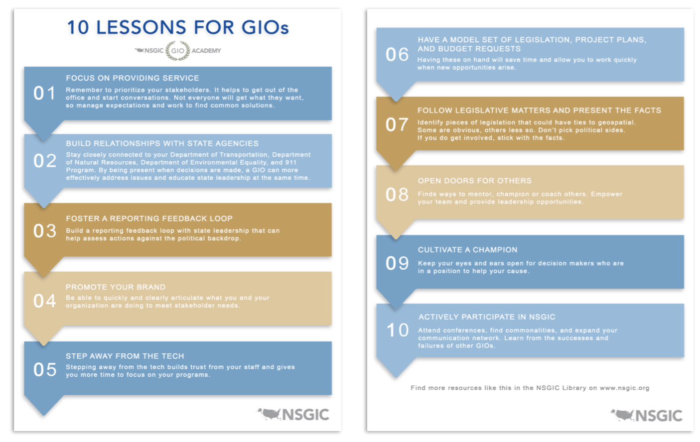
10 Lessons for GIOs
By Karen Rogers | April 24, 2019
In conjunction with our first in-person GIO Academy, NSGIC has produced a document outlining 10 key lessons for GIOs. The document includes direct advice like “Step away from the tech,” as well as broader guidance like “Open doors for others,” prompting GIOs, new and seasoned alike, to evaluate how they approach team management, interdepartmental coordination, legislative matters, and more. No matter how long you’ve been in the field, I think you’ll find helpful nuggets of advice in this document that will continue to evolve.
Download the PDF
Second Geo-Enabled Elections case study: Wisconsin identifies data quality and auditing as critical to success
April 23, 2019
Wisconsin’s elections are fully geo-enabled, after a conversion process that started in 2011. The state had concluded that implementing GIS would make the process of assigning voters to the right districts, following the 2010 census and redistricting, more efficient and accurate.
The Wisconsin team’s biggest challenge by far turned out to be the quality of available data - both for voter addresses and for district shapefiles (the geospatial data format that defines geography). While data has improved significantly over time, finding sources of high-quality data to use for auditing and quality control remains a concern, and the team shares some of the approaches considered and used.
State Spotlight: Kentucky
Kent Anness
GIS Manager, Kentucky Office of Technology
Interviewed by Sheila Steffenson | April 3, 2019
Kentucky GIS Manager Kent Anness has been working in GIS for 30 years and state government for 20 years. Anness got his start in cartography and initially used a scribe tool and darkroom methods for producing map compilations.
Anness says that over the past 20 years, not only has the technology grown, but the accessibility of enterprise GIS has grown as well, allowing for an increased number of users within state government. According to Anness, newer generations see even greater value in the technology.
The biggest success related to GIS in Kentucky, says Anness, is the completion of statewide LiDAR coverage via the KyFromAbove program.
First case study released: Utah shares its experience integrating GIS in elections
March 21, 2019
Utah had long considered integrating GIS data into its election processes, but it was the 2010 census that prompted the state to take action. Election administrators had observed that the changing of political boundaries at any level tended to expose the shortcomings of the old list-based system. At the same time, the state was committed to ensuring that in each election, the right ballot would be sent to the right voter – and it wanted the ability to accomplish that goal with a minimum of administrative effort. As a result, the lieutenant governor’s office initiated a project to implement GIS in Utah’s electoral system, in order to make “redistricting” easier ahead of the 2012 election.
Five statewide pilot studies launched to further geo-enabled elections
March 8, 2019
On March 4, NSGIC launched five state-wide pilot studies across the nation, when state geographic information officers (GIOs) and election directors (EDs) from Kentucky, Minnesota, Nebraska, Pennsylvania, and West Virginia came together with subject matter experts to develop plans for their respective three-month pilot projects.
Each state is committed to furthering the use of GIS in elections, and the pilot studies are designed to support and record their experience as they tackle select next steps on that path.
State Spotlight: New Jersey
Andy Rowan
Geographic Information Officer, NJ Office of Information Technology
Interviewed by Sheila Steffenson | March 1, 2019
New Jersey Geographic Information Officer Andy Rowan says that after 13 years in state government, “the biggest challenge remains a gap in awareness outside of the state’s GIS community regarding the capabilities of GIS technology.” Awareness and education can be obstacles in taking any state GIS program to the next level.
Rowan’s career in GIS started when he was a junior staff member at a small environmental consulting firm. When one of the firm’s senior scientists became convinced GIS should be brought in, earth scientist Rowan -- with the most bandwidth -- was tapped to take it on. The firm sent him to training and he never looked back.
In addition to his role as the state’s GIO, Rowan recently served two years as Deputy Chief Technology Officer. During his time in state government, he has witnessed a shift in focus from building new GIS data to maintaining the data that exists. “There is a relentless march towards accuracy improvement,” says Rowan.
COGO releases 2018 Report Card on the U.S. National Spatial Data Infrastructure (NSDI)
Bronwyn Walls | February 5, 2019
The Coalition of Geospatial Organizations (COGO) has announced the release of its 2018 Report Card on the U.S. National Data Infrastructure (NSDI). The report card utilizes a letter grading system to depict the status and condition of the nation’s geospatial infrastructure.
Notably, the national assessment of the NSDI’s ability to meet future geospatial data, based on address, cadastral, elevation, geodetic control, government units, hydrography, orthoimagery, and transportation themes, rose from a C in the 2015 Report Card, to a B- in the 2018 Report Card.
“The new report card exemplifies that while progress has been made, federal, state, regional, and local government agencies, tribal nations, and private and academic sectors need to continue to collaborate to complete this important work,” says NSGIC President Dan Ross. “NSGIC fully supports that collaboration and will continue to work with our members to support and move this initiative forward.”
NSGIC Releases Groundbreaking Survey of Election Directors' Take on Their Progress towards Implementing GIS in Elections
January 30, 2019
NSGIC has released findings from a first-ever survey of the nation’s state election directors, seeking to determine the current status of the implementation of GIS in elections. A number of states have championed the use of this technology in recent years to strengthen the accuracy and reliability of their electoral systems, and NSGIC’s Geo-Enabled Elections project was created to assist states and other election authorities in this process.
According to the new Election Director Report, state election directors indicate knowledge and interest in GIS technology. However, the report’s findings also suggest that most states have a long way to go to fully utilize geospatial information in elections.
State Spotlight: Massachusetts
Neil MacGaffey
Director, MassGIS
Interviewed by Sheila Steffenson | January 16, 2019
In his 18 years of working in state government, Massachusetts’ GIS Director Neil MacGaffey said he has seen the “steady push to a larger and larger scale of mapping. Resolution of all data has improved. Statewide mapping of parcels, addresses, and structures now exists and is a game changer.”
The state completed standardized statewide parcel mapping in 2013.
“The availability of this information statewide has had an extraordinary impact across a broad spectrum of uses,” MacGaffey said. “There are terrific stories on what the availability of this data has enabled. Parcel data is the single most popular data set, whether accessed via download from the MassGIS website or through web mapping services.”
Information Sharing & Priority Setting: The Rhythm of State GIS Coordination
By Molly Schar | January 7, 2019
For state Geospatial Information Officers and statewide GIS coordinators, engaging with GIS leaders is one of the biggest parts of the job. The most common mechanism is regular meetings with state agency GIS leaders, although the frequency and formality vary greatly by state.
Frank Winters, New York GIO, noted, “New York has a Geospatial Advisory Council which meets quarterly. The council has representations from every sector but is intentionally weighted to local governments. Since New York has centralized IT support, much of the engagement with agencies is done through normal IT governance.”
“In Vermont, we meet monthly. We have a charter signed by agency secretaries and we have annual business plans,” said John Adams, Director for the Vermont Center for Geographic Information. “The group includes 11 voting representatives from different agencies/departments, with more people attending depending on the agenda. Standards and policies are primarily worked out by subgroups. For the past year, we’ve been having ‘GeoEnlightenment’ sessions an hour before each meeting, which typically involves a guest speaker. These have been well received.”
“In the state of Montana, we hold monthly meetings with state agency GIS managers and leads,” explained Erin Fashoway, Montana State GIS Coordinator. “Our discussions include agency technical needs, presentations on agency’s successes and failures, Montana Spatial Data Infrastructure (MSDI) data updates, and reviewing state policy/best practices, as well as the non-technical issues such as software contracts. We are about to go through the process setting goals for the upcoming year.”
NSGIC Releases First-Year Report for Geo-Enabled Elections Project, Including First Draft of Best Practices for Implementing GIS in Elections
Jamie Chesser | December 17, 2018
National States Geographic Information Council (NSGIC) has released the first-year report of phase one of its Geo-Enabled Elections project, highlighting the project’s accomplishments in the first twelve months. These include completing a baseline assessment of how far states have come, to date, in terms of integrating geographic information systems (GIS) with electoral systems, as well as assembling a team of leaders and experts to help guide the project. The project team has also facilitated conversations with a wide range of stakeholder groups, aimed at raising awareness of the importance of using geospatial technology to increase reliability and accuracy in elections.
South Central TX LiDAR Project
Enhanced Hydrology in Texas LiDAR by Merrick-Surdex JV Critical to Risk Mapping
Sponsor Content
In 2017 the USGS selected the Merrick-Surdex Joint Venture to collect and process LiDAR data of approximately 17,950 square miles in Southwest Texas. One of the funding partners to the project, FEMA, required new elevation data in order to reclassify older hydrographic features to improve flood map accuracy. The data will be used to assist in risk management of potential flooding areas, due to significant shifts in precipitation over the past decade.
The State of Texas has experienced a nearly decade-long drought; in February 2018, nearly 90% of the state was under a drought warning. Within one year, these conditions shifted dramatically – in 2018, rains had been so persistent and heavy that by October less than 5% of the state was under a drought warning. This sudden increase in such a large volume of water has created a scenario with a notable risk of overflowing and flooding of once-dry riverbeds. The state consequently switched from a drought status to a situation of potential widespread flooding, with all the subsequent possibility of damage. FEMA and Texas Water Development Board (TWDB) anticipating the effects of such a situation, initiated a project with the USGS to obtain data to manage this new condition.
State Spotlight: Utah
Matt Peters
Automated Geographic Reference Center Director
Interviewed by Tim Bohn | November 28, 2018
For Utah GIO Matt Peters, successful statewide GIS coordination is all about communicating a vision and helping everyone speak the same language. It takes strategy and finesse, he said, to “make sure the tide raises all boats.”
Helping stakeholders embrace that vision means focusing on the data rather than getting caught up in the technology. “Data is the foundation and is fundamental to analysis,” he said. “For example, address ranges affect geocoding, so if the quality is not there, nothing moves forward. Today … improved, polished data [is available] for use in web services. Point-in-polygon matching is also more accurate.”
In fact, said Peters, the goal is that “the map is an afterthought [because] it’s all about the data. Used data gets better.”
Licensed Commercial Imagery as an Enterprise Resource: The Terms Matter!
By Bert Granberg | November 19, 2018
“Let’s get everyone working on the same map!”
This is a compelling, succinct goal that speaks to the value of taking an ‘enterprise-wide approach’ to acquiring GIS data resources, including high-resolution aerial photography. It’s a safe bet that the “on the same map” argument was part of the advocacy efforts of states that have successfully sought and received support to build public domain imagery programs.
“On the same map” is also a very relevant objective for states or regions (or even nations) considering a licensed imagery purchase from the emerging market of commercial aerial products. While public domain programs are a great goal, in recent years there has been more growth in the adoption of statewide licensed programs, perhaps because of lower, but not perfectly comparable costs. In a mature geospatial world, imagery is probably an open, public domain resource, but if you’re not there yet, a licensed product could be a good fit.
Aerial imagery is critical information for a very diverse range of key work sectors. It’s used as a critical basic geographic reference, but also as a platform for creating and new map data of all kinds. Most of us remember when the originating map scale was always atop the importance list for selecting and using GIS data layers. Those days are mostly over thanks to the pervasive use of digital aerial photography as a base for digitizing new data, and of course, GPS and other field surveys. For this and other reasons, we should think of aerial imagery as an ‘information utility’, akin to how we view the National Weather Service.
Senate Passes GIS Day Resolution Following Successful Passage of Geospatial Data Act
By Molly Schar | November 15, 2018
Senator Orrin Hatch (R-UT) and Senator Mark Warner (D-VA) led a Senate resolution to designate November 15, 2018 as “National GIS Day.” Senators Baldwin (D-WI), Blumenthal (D-CT), Capito (R-WV), Hassan (D-NH), Inhofe (R-OK), and Wyden (D-OR) joined Hatch and Warner in submitting the resolution.
“The Senate designates November 15, 2018, as ‘National GIS Day’; encourages users of Geographic Information System technology … [including] educators, students, and innovators to continue to employ GIS to learn and explore, to analyze and address societal challenges; and to drive economic growth for the betterment of the people of the United States and individuals around the world.” the three-page resolution concludes.
This recognition by the Senate punctuates the passage of the Geospatial Data Act, included as a component in H.R. 302, the FAA Reauthorization Act signed into law last month.
State Spotlight: Florida
Ekaterina Fitos
State Geospatial Information Officer
Interviewed by Tim Bohn | November 13, 2018
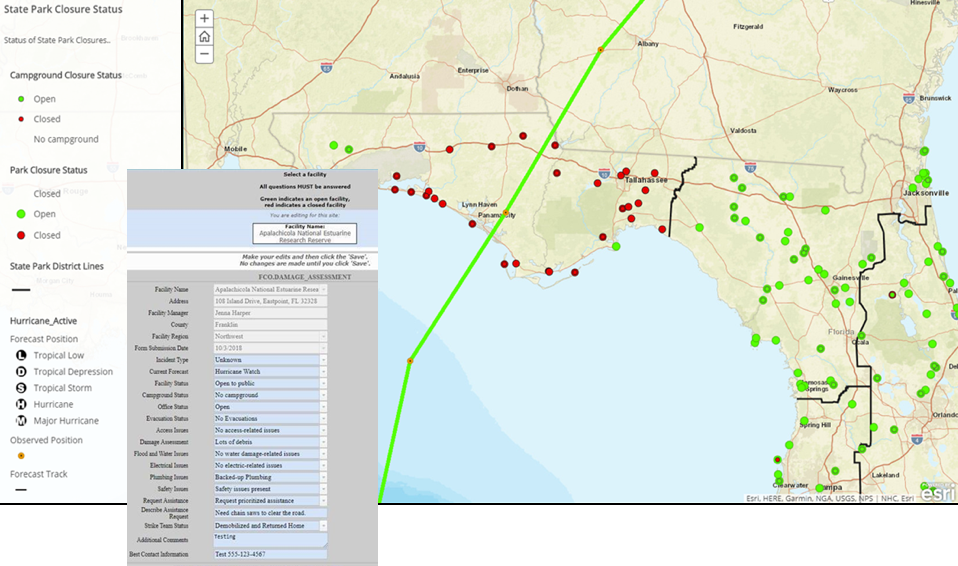
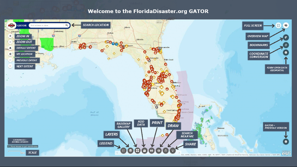
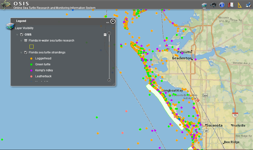
Florida is a big, complex state, said GIO Ekaterina Fitos, and the key to coordinating GIS across the state is through a collaborative enterprise approach with GIS focused work groups and engagement of stakeholders.
Just ten months into the job as Florida’s first GIO, Fitos said she is continuing to assess Florida’s statewide spatial data infrastructure. There are plenty of success stories, she said, citing the Florida Department of Environmental Protection’s mobile applications one of which assists with notifying the public about state park closures during disasters (Figure 1), the GATOR web application by the Florida Division of Emergency Management (FDEM) (Figure 2), and an online system to monitor sea turtles developed by the Florida Fish and Wildlife Commission (FWC) (Figure 3).
Figure 1. FDEP State Park Closure Application and Map Direct Form
Figure 2. GATOR Application
Figure 3. Online Sea Turtle Research and Monitoring Information System
Carpe Geo: Becoming a Great GIS Leader
Sponsor Content
How can you grow into the GIS leader you aspire to be? How can you work better with others? How can you get the most satisfaction out of your GIS career? These are questions that AppGeo believes can be answered through thoughtful application of Carpe Geo principles. Carpe Geo is about seizing the opportunities to do great things with GIS.
Those of you who attended the 2017 NSGIC Annual Conference in Providence, RI may remember hearing Bill Johnson’s Carpe Geo & Parvum Momentum presentation, where he first introduced us to these ideas. Since then, Bill has joined the AppGeo team and at this year’s NSGIC Annual he followed up with Carpe Geo, Part Deux, which explored how the principles of Carpe Geo can help you become a better GIS leader.
Becoming a great GIS leader doesn’t happen overnight. To better understand how one grows and metamorphosizes into that role, consider three lenses or models that can help you understand the growth path.
State Spotlight: Minnesota
Dan Ross
GIO, Chief Business Technical Officer and CIO, Pollution Control
Interviewed by Tim Bohn and Tim Donze | October 22, 2018
Minnesota GIO Dan Ross has spent 23 years in state government if you include the three years he spent as a system administrator and adjunct professor teaching GIS at St. Cloud State. In that time, he has seen GIS go from highly collaborative to falling off, and now in resurgence with both data sharing and a standards development.
Five years ago, said Ross, there were no statewide parcels, centerlines with address ranges, addresses or standards to support those data layers. The state “is in much better shape now,” he said. “The community has come together and renewed the collaboration.”
In that time, Ross spearheaded an effort to convince the Minnesota legislature that taxpayers were paying for data three to five times over because of the tremendous duplication of efforts. The efforts resulted in a law that mandated government-to-government sharing of data at no cost. In addition, the Minnesota Geospatial Commons was established. The Geospatial Commons - a collaborative place for users and publishers of geospatial resources about Minnesota - has won multiple national awards. The state’s spatial data infrastructure currently contains more than 750 layers, with about 194 web services available for access.

State Geospatial Policy Organization Lauds “Geospatial Data Act” Language Included in FAA Reauthorization Bill
By Bronwyn Walls | October 3, 2018 | Duluth, MN
Participants at the National States Geographic Information Council (NSGIC) Annual Conference cheered at the news that the Federal Aviation Administration (FAA) reauthorization bill passed the Senate this morning.
The legislation contains provisions critical to building the national spatial data infrastructure by establishing a clear vision, assigning responsibility, providing authority and ensuring oversight of federal activities by Congress. The bill includes language previously winding its way through both houses as a standalone bill called the Geospatial Data Act.
“This is a major win for the entire geospatial community. We thank and commend our nation’s lawmakers for enacting this meaningful legislation,” said Dan Ross, geospatial information chief for the state of Minnesota and NSGIC president. “NSGIC members coordinate geospatial policy, technologies, and services across our states. We have the unique perspective of seeing across states - and, together, across the nation - to evaluate the substantial and significant unmet needs stemming from a failure to harness and coordinate efforts. ”
The bill, having cleared both the House and the Senate, will now be sent to the White House to be signed into law.
“The Geospatial Data Act has been a top legislative priority for NSGIC for several years. We have worked with state governments, Congressional offices, federal agencies, and many other stakeholder groups committed to building more resilient communities by ensuring they will have access to the consistent high-quality data they need to do their jobs,” said Molly Schar, NSGIC’s executive director.
'Imagery for the Nation' as Timely as Ever
By Bert Granberg | September 24, 2018
Aerial photography is an incredibly valuable resource to a broad set of sectors in the business, government, and research sectors. An aerial view, whether from a satellite or an airborne camera, provides excellent situational awareness, for among other things:
- Responding to a crisis - like 911 centers coordinating response to everyday emergencies or coordination for wildfires, flooding, and hurricanes
- Informing real-time consumer decisions and organizational operations - everything from tourism to package delivery
- Planning for the future - like siting and designing new developments and transportation projects
- Building map-based datasets of infrastructure and natural assets - to better inventory and analyze how urban and natural systems perform
- Providing a historical record over time - for dispute resolution and understanding development and change patterns
While it is expensive to acquire, it is practically indisputable that the immense value of accessible, up-to-date, and high-resolution aerial photography dwarfs the costs to capture and distribute the imagery.
So what's the problem? In a nutshell, there's no national model in place to efficiently fund, collect, and provide access to this highly desirable resource, that - unlike most types of products - actually becomes more valuable the more it is put to use.
Homeland Security Study Focusing on GIS Infrastructure for Disasters
By Richard Butgereit | September 19, 2018
On NSGIC’s behalf, I recently attended the second workshop of the DHS Disasters Interoperability Concept Development Study being conducted by the Open Geospatial Consortium (OGC).
This workshop follows the announcement that the Department of Commerce Economic Development Administration has $587 million in FY18 supplemental appropriations available for disaster recovery grants.
For the concept development study, OCG is bringing together key stakeholders in the natural hazards disaster communities to assess the current state of data and product exchange technologies used in disaster planning, response, and recovery. The results will aid in developing a series of pilots to advance the state of spatial data infrastructures that support global disaster risk reduction.
I was in good company in the workshop:
-
Executive-level participants there to understand this issue’s most important challenges
-
Operational and technical stakeholders there to gather and share information on the current state for using geospatial data and services during natural disasters
-
Diverse group of vendors and consultants there to identify potential requirements for pilots
-
Other stakeholders in public sector disaster response
A series of panel discussions offered several perspectives covered in the study.
Pilot Project Kicks Off for 3DEP for the Nation Initiative
By Molly Schar | July 18, 2018
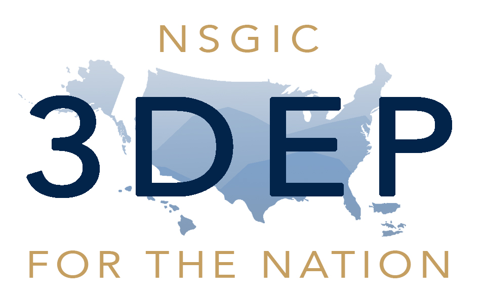
Seven states will be testing the state lidar acquisition planning guide developed by NSGIC as part of the 3DEP for the Nation collaboration with the USGS National Map 3D Elevation Program and the Federal Geographic Data Committee 3DEP Working Group. Iowa, Illinois, Montana, Ohio, Tennessee, Washington, and Wisconsin will receive a draft of the guide to put into action and report monthly on what worked, what’s insufficient, what’s missing, and which external resources should be referenced. This information will help to refine the guide, which is due to be completed for NSGIC membership use and comment as early as February 2019.
3DEP for the Nation addresses the need for high-quality topographic data and three-dimensional representations of the nation’s natural and constructed features. Believing 3DEP coverage across the US can be most effectively achieved by establishing plans for each individual state and territory, NSGIC is leveraging its strong working relationships with state geospatial information officers and coordinators to develop these plans.
NSGIC State Representatives Share How Elections Systems Work in Their States
July 12, 2018

More than two-thirds of states responded to a nationwide survey on elections data conducted in the first half of 2018. Responses were coordinated by state government representatives who focus on the development and deployment of mapping data and systems across state agencies and local governments.
“An electoral system with integrity - enhanced by accurate, authoritative geographic data and presented clearly and transparently - has never been more important,” said NSGIC President Andy Rowan.
“Geo-enabled elections overcome the four fundamental challenges with the existing address list approach to precinct management,” said Rowan. “In the address list approach, no actual boundaries are stored explicitly in these systems; quality control is difficult without a method to visualize precinct assignment using aerial photography and boundary information that can change frequently; there is no efficient method for applying large-scale precinct boundary updates; and the process is usually not aligned efficiently with other state and local address or boundary management processes.”
New Podcast Explores Role of GIS in Government
In a new collaboration, NSGIC and StateScoop have launched GIS Addressed to feature the perspectives of state government GIS experts on key issues. The series connects the dots between why geographic information systems are important and how they fit into government technology agency operations and initiatives.
"Geographic information systems have been a part of the fabric of government for decades. Now, in an era of increased focus on the centralization of technology and on information technology agencies within state and local government, a new day is here for GIS. And it could completely change how technology, data, mapping and more function in government," says Associate Publisher and Director of Strategic Initiatives at StateScoop, Jake Williams.
Kim Cloud Receives Delaware Award for Excellence and Commitment in State Service
June 18, 2018

Major kudos to NSGIC member Kim Cloud, who received the Delaware Award for Excellence and Commitment in State Service for her work with geographic information systems (GIS) at the Delaware Governor’s Awards Ceremony on May 7, 2018. The award is a statewide recognition given to five State of Delaware employees, or groups of employees, who exemplify the highest standards of excellence and commitment in state service.
The Department of Technology and Information (DTI) nominated Kim Cloud for the Delaware Award for Excellence and Commitment in State Service because of her outstanding state service and ongoing commitment to DTI. Kim has worked at DTI since July 19, 2004, and has spent her tenure as a software engineer for the Application Delivery team. Kim’s passion is working with geospatial data (location-based data) and GIS software and tools, i.e. FirstMap, which is a GIS solution that provides a centralized repository and enables users to maintain and analyze spatial data.
Value of a GIO
By Andy Rowan | May 8, 2018
Having spent a dozen years in the role of state GIO, I have thought a lot about the importance of that work. We in government GIS often talk in terms like “coordination,” and certainly coordination and governance is the core of what a GIO does. But why is it so much more important in GIS than in other subdisciplines of IT? The rest of the data world is catching on, with the (fairly recent) advent of chief data officers. But we in GIS have been talking about and working on those issues for as long as I’ve been in the field.
What’s so special about spatial? I think it comes down to a simple fact. The great majority of the financial investment required to get a GIS initiative to the finish line goes into data that is not specific to the project. That’s really not true in other data-intensive disciplines. It was especially true in the early days, but foundational data continues to be a substantial investment. The data that it takes to make a plain old base map adds up to a big cost. And everybody doing GIS needs that same base map data. So it has always been obvious to anyone without unlimited funds that they’re better off sharing that cost. And that only happens through coordination.
Federal Agencies Support State Lidar Plans in “3DEP for the Nation” Project
By Lynda Wayne | April 23, 2018
.png) NSGIC’s participation in the recent USGS 3DEP Working Group meeting gave us a chance to connect with NRCS, USGS, FEMA, NOAA, USFWS, USACE, USDA FS, and other federal agencies to discuss a strategy for completing national lidar coverage by 2023. (Acronyms translated below.) Coordination with and within US states and territories is a key component of this strategy and NSGIC, with a grant from USGS, is taking the lead on that coordination. NSGIC’s participation in the recent USGS 3DEP Working Group meeting gave us a chance to connect with NRCS, USGS, FEMA, NOAA, USFWS, USACE, USDA FS, and other federal agencies to discuss a strategy for completing national lidar coverage by 2023. (Acronyms translated below.) Coordination with and within US states and territories is a key component of this strategy and NSGIC, with a grant from USGS, is taking the lead on that coordination.
Support for Geospatial Data Act More Critical Than Ever
By Molly Schar | April 6, 2018
In the last Congress - the 114th - some 9,600 bills were introduced. Less than 4% of them were signed into law. These are daunting numbers when you are pushing for a piece of legislation that you think is important enough to make it to the finish line. NSGIC has encouraged members of our community to support the Geospatial Data Act (S.2128 and H.R.4395) from the start, but that support has never been as critical as it is right now.
On a conference call with other member of the Coalition of Geospatial Organizations (COGO) this week, there was significant discussion about some of the issues standing in the way of unanimous support. Several organizations (NSGIC included) have been working to develop language palatable to associations with vastly different memberships. Folks in the open data/open government community have expressed concern about language around proprietary or licensed data being available on the GeoPlatform. Still others are caught up in a desire to include language related to licensure and procurement. Neither of these issues is appropriate to try to resolve in this bill. It should be noted, however, that the Geospatial Data Act is fundamentally an open data bill.
The irony is that without exception (to my knowledge, anyway), the geospatial community can agree that what the Geospatial Data Act is trying to accomplish is a good thing. The legislation codifies existing executive orders and other guidance documents that direct the work of the Federal Geographic Data Committee (FGDC), the body that promotes national coordination in developing, using, sharing and disseminating geospatial data. It gives the FGDC the authority to make federal agencies follow some existing common sense rules and provides Congressional oversight over the geospatial activities of FGDC members and other agencies. It provides a great deal more clout to input developed by the multi-sector membership of FGDC’s National Geospatial Advisory Committee. And very importantly to NSGIC, it requires federal agencies to coordinate and work in partnership with other federal agencies, agencies of state, tribal, and local governments, institutions of higher education, and the private sector with the collective goal of achieving a robust national spatial data infrastructure.
Midyear Meeting Takeaways for the Geo-Enabled Elections Project
By Jamie Chesser | March 19, 2018
NSGIC's Midyear Meeting - held last month in Salt Lake City - was an extremely productive time for the Geo-Enabled Elections project. Our steering group met in person for the first time, we held a four-hour workshop for conference participants, including state and federal government representatives, sponsors and other partners, and we ended the week with a well-attended plenary session.
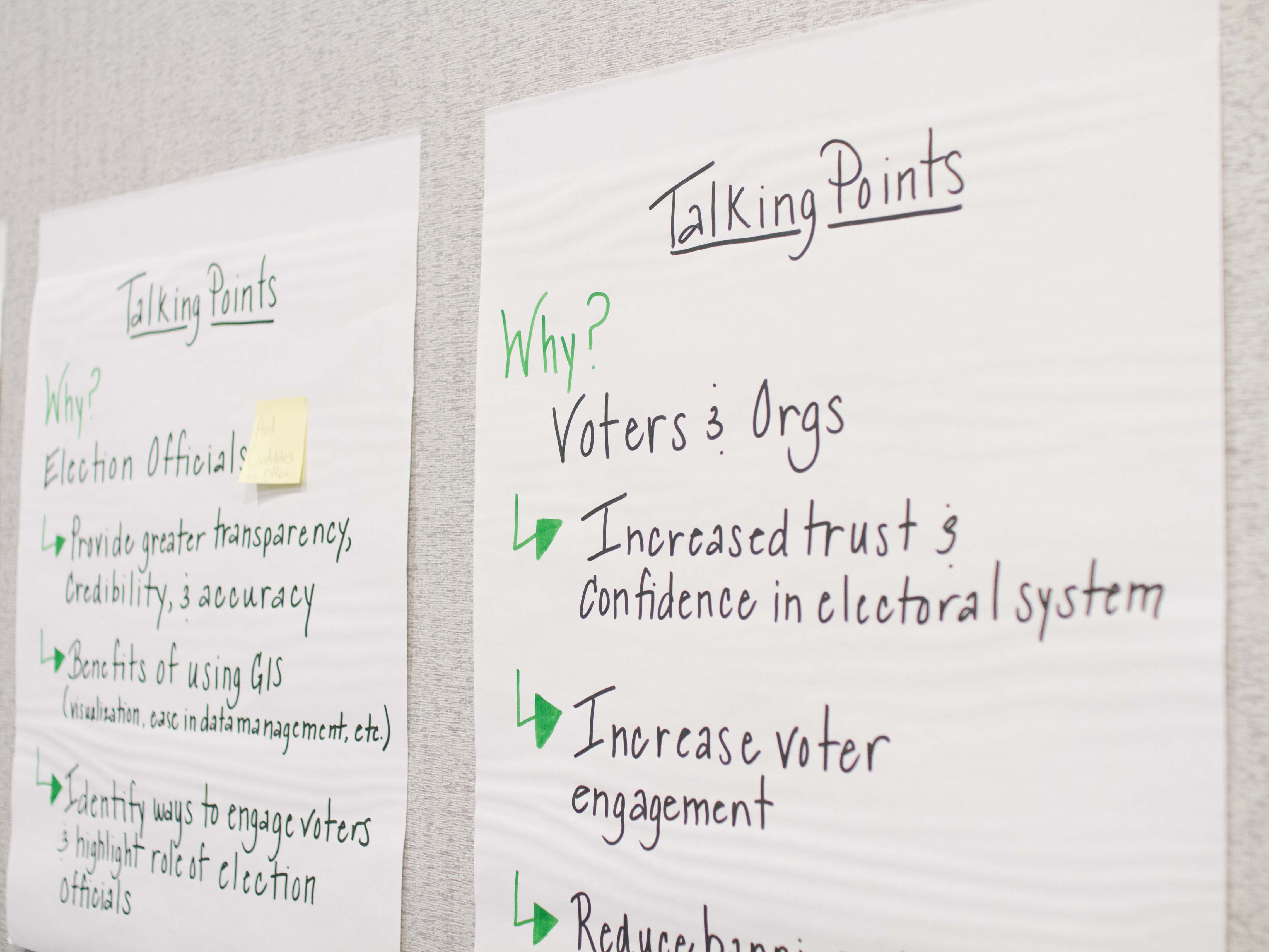
The 13 members of the steering group met for a pre-conference workshop and identified a short list of best-practice areas to position a state for geo-enabling their elections system. These initial items are:
- Statewide precinct layer with an associated maintenance process
- Current statewide address info
- Implementation options that give local control for locating address data
- Standardization of terminology
- System or process where GIS technologies and data are locally sourced and rolled up to the state
- Contextual map data (for example, current aerial photography)
NSGIC Hiring Membership & Meetings Coordinator
Come work for NSGIC! We are hiring a new Membership & Meetings Coordinator who will focus on the areas of membership, events management and administration. Familiarity with the geospatial community and association experience are especially helpful. View the job posting for more information and to submit your resume.
Enhancing the Arizona Address Data Management Ecosystem: Midyear Meeting Presentation Highlight
By Jenna Straface | February 8, 2018
This week we are highlighting a presentation titled “Enhancing the Arizona Address Data Management Ecosystem," presented by Jenna Straface, Gene Trobia, Bo Guo, and Howard Ward on Tuesday, February 27. Read Jenna's presentation description below for a preview of the discussion content:
As one of the two original pilot states for the National Address Database (NAD) project, Arizona continues to build a statewide address management ecosystem. Key success factors include support of the Arizona Geographic Information Council (AGIC) and the Arizona State Land Department (ASLD), active state and local government collaboration, strategic public and private partnerships, participation in NSGIC's Address & Transportation Committee’s identification of national guidelines and best practices, and the adoption of new technology to improve data workflows and validate authoritative addresses.
The presenters will provide a brief overview of the Arizona Address Management Ecosystem and discuss several of its key components.
GIS in Computer Science Education: Midyear Meeting Panel Highlight
By Karen Rogers | February 5, 2018
With our Midyear Meeting fast approaching, we wanted to slow down and take a moment to highlight some of the presentations and panels that we are looking forward to. The first panel we are highlighting is titled “GIS in Computer Science Education” and will be presented by Karen Rogers (WY) on Thursday, March 1. Read Karen’s statement below for a preview of the discussion content:
I was asked to be on the Computer Science Education Task Force in Wyoming, an effort led by the Department of Education. This diverse group has been meeting since September of 2017 to formulate strategies and ideas for integrating computer science (CS) in the classroom, as well as encouraging elected officials to pass legislation to formally acknowledge the importance of CS being taught to all grades in all schools.
Geo-Enabled Election Project Gathers Momentum
By Jamie Chesser | January 23, 2018

When I joined the NSGIC staff a month ago as the geospatial programs manager, I learned very quickly that NSGIC is all about collaboration. This was great news to me because my focus in the next two years will be on the Geo-Enhanced Elections project, and it’s going to require a lot of collaboration!
GIS is relatively new to state elections implementations, though we are aware of several successful state implementations. When complete, a full GIS integration with a state election management system creates a map-based model of all the geographic features that interact in the election process and its results: district, precinct and ballot area boundaries; voter residence locations; polling places and drop-off locations; and address-based presentation of elected officials. The GIS digital model can significantly enhance accuracy, transparency, and efficiency of our representative government.
The Geo-Enabled Elections project fits within NSGIC’s “sweet spot” of working together to advance valuable state GIS capabilities through coordination, collaboration, communication and subject matter expertise support.
Transitioning ...
By Bert Granberg | January 11, 2018
Nobel Prize winner George Stigler said “a transition period is a period between two transition periods.” After almost 17 years with Utah’s Automated Geographic Reference Center (AGRC), five of them as director, I am about to transition into a new role with a new organization.
 Next week, I’ll hand over my key card to the Utah AGRC office, take a two week break, and then head down the street to the Wasatch Front Regional Council, the metropolitan planning organization for the Salt Lake - Ogden metro area. My new job is leading WFRC's section of GIS, data science and transportation modeling staff, in supporting mid- and long-term planning for infrastructure projects, transit, economic development, land use and air quality. Next week, I’ll hand over my key card to the Utah AGRC office, take a two week break, and then head down the street to the Wasatch Front Regional Council, the metropolitan planning organization for the Salt Lake - Ogden metro area. My new job is leading WFRC's section of GIS, data science and transportation modeling staff, in supporting mid- and long-term planning for infrastructure projects, transit, economic development, land use and air quality.
This change is bittersweet, for sure, for many reasons - I am leaving a job that I’ve loved and found fulfilling, with an outstanding team and colleagues across state and local government - and also because I will be passing along Utah's NSGIC State Rep torch (a la Minecraft) that has connected me to so much expertise and important personal and professional connections.
NSGIC Welcomes New Staff Members
December 19, 2017
NSGIC recently announced the addition of two new staff members to the team: Bronwyn Walls as Communications Coordinator and Jamie Chesser as Geospatial Programs Manager.
 
Mapping the Last Frontier: NOAA Award to Assist Alaska's Rural Coastal Communities
By Anne Johnson | December 7, 2017
Alaska was recently selected to receive a 2018 - 2020 Digital Coast Fellowship. This award will provide long-term benefits for Alaskans who reside in coast communities, 80 percent of whom are vulnerable to extreme weather events and storm flooding.
The project - titled Bringing Alaska Coastal Communities Online to the Digital Coast: Coastal Flood Mapping for Rural Alaska - will build upon existing data, online mapping tools and partnerships to assist Alaska in responding to coastal flood hazards.
GIS Day Marks Reintroduction of Geospatial Data Act
By Andy Rowan | November 15, 2017
This afternoon, the Geospatial Data Act (GDA) was introduced in the Senate by Senators Hatch (R-UT), Warner (D-VA), Heller (R-NV), Wyden (OR), Boozman (R-AR) and Klobuchar (D-MN) as S.2128 and in the House by Representatives Westerman (R-AR) and Moulton (D-MA) as H.R.4395. NSGIC has supported the GDA in a few different forms, it having been introduced in a previous Congress, as well as having undergone revisions since its last introduction. It has retained its critical core – developing a national spatial data infrastructure (NSDI) that will significantly improve government services for citizens across the country.
Working with partner organizations, we delivered a GDA support letter that included other well-respected national organizations and geospatial technology and services companies. It is the strongest showing of support for the GDA that has ever been garnered. I had the opportunity to join a few NSGIC colleagues – Cy Smith (OR), Shelby Johnson (AR), Dan Ross (MN) and our executive director, Molly Schar – for a Capitol Hill GIS Day reception we co-hosted with AAG and Esri. It was an excellent opportunity to speak with lawmakers and their staff members about why the GDA is so important, and it also gave us a chance to talk with the other nonprofit and corporate representatives in the room who are our partners in supporting this legislation. With transparent and coordinated advocacy efforts, we can leverage the momentum building in the geospatial community for this bipartisan, “good government” bill.
As I said in my remarks during the reception this afternoon, developing a national spatial data infrastructure is a concept that we have struggled with for the past 24 years – since the signing of Executive Order 12906 in 1993. The NSDI has mostly been a federal effort, with little relevance for state, tribe, regional or local governments. The GDA codifies the existing NSDI governance structure and mandates Congressional oversight of federal geospatial expenditures, which are two very important outcomes. But from the perspective of state governments, there are two other provisions of this bill that will make a significant difference and with make the national spatial data infrastructure much more possible.
Is the Future of NAIP Aerial Photography in Trouble?
By Molly Schar | November 14, 2017
 Potential changes to the USDA's NAIP one-meter color aerial photography program was a hot topic of discussion at today's FGDC Coordination Group meeting. Potential changes to the USDA's NAIP one-meter color aerial photography program was a hot topic of discussion at today's FGDC Coordination Group meeting.
In response to reduced funding, USDA is currently reevaluating the efficacy of the NAIP program. Reduced funding for NAIP is due to agency budget cuts, partially met commitments by federal partner agencies outside of USDA, and later-than-desired transfers of partner funding that require USDA to take on extra financial risk.
Accordingly, the NAIP acquisition contract renewals will be for one year only in 2018 and the NAIP flights are slated to move back to a three-year cycle. Notably, USDA is considering subscribing to a commercial imagery subscription starting as early as 2019, and has determined that a USDA-only COTS license would meet USDA needs while cutting their internal acquisition costs by 50% and improving resolution by 2x. USDA also stated that it was clear that it would only take a few agencies acquiring their own exclusive commercial imagery subscriptions before those costs exceeded the overall cost of NAIP.
USGS 3DEP Lidar Indexing for Continental US
By Bert Granberg | November 13, 2017
Last month, the USGS released a 2 page fact sheet outlining their plans to align their 3DEP Lidar program with a standardized national grid. The proposed grid would guide the shape of proposed 3DEP grant projects (optional for 2018 but required in 2019) and, presumably, the distribution files for 3DEP data.
This new component of the 3DEP program has been encouraged by NSGIC members in recent years. The grid may prove useful as a framework for negotiating coverage and costs between adjacent project/interest areas. It is also likely the grid will help USGS facilitate 'infill' between larger gaps found between proposed projects and/or existing data.
NSGIC Launches "Geo-Enabled Elections" Project to Enhance Elections Management with Geospatial Data & Technology
By Molly Schar | November 2, 2017
Today, the National States Geographic Information Council (NSGIC) announced a two-year project dubbed “Geo-Enabled Elections” to boost state-led efforts to standardize the application of geographic information systems (GIS) to support elections management and engagement between office holders and their constituents. These essential upgrades will benefit voters by increasing political boundary precision—so they know with certainty who represents them and what will be on their ballots each election.
The Geo-Enabled Elections project will compile and promote best practices for the use of GIS to develop and sustain a map-based digital database to support state election offices that contains:
- State, municipal, and local service district boundaries
- Voting precinct boundaries, precinct assignments, and polling places
- Constituent service areas to connect residents to elected officials, government services, public notices, and other location specific information
Happy Ada Lovelace Day - Celebrating Women in STEM
By Nathalie Smith | October 10, 2017
Today is Ada Lovelace Day, a day to celebrate the achievements of women in science, technology, engineering and mathematics (STEM).
I first became aware of this celebration three years ago by happenstance when a friend of mine simply asked, "Are you doing anything special on Ada Lovelace Day?" I wasn't - I had no idea who Ada Lovelace was and what Ada Lovelace Day was about. Wikipedia quickly filled in the blanks.
 Augusta Ada King, Countess of Lovelace (December 10, 1815 - November 27, 1852) was the only child of the poet Lord Byron and his wife Anne Isabella Byron. Byron separated from his wife a month after Ada was born and left England forever four months later. Ada's mother remained bitter at Lord Byron and promoted Ada's interest in mathematics and logic in an effort to prevent her from following in her father’s footsteps. Augusta Ada King, Countess of Lovelace (December 10, 1815 - November 27, 1852) was the only child of the poet Lord Byron and his wife Anne Isabella Byron. Byron separated from his wife a month after Ada was born and left England forever four months later. Ada's mother remained bitter at Lord Byron and promoted Ada's interest in mathematics and logic in an effort to prevent her from following in her father’s footsteps.
As a young adult, her mathematical talents led her to an ongoing working relationship and friendship with fellow British mathematician Charles Babbage, and Babbage’s work on the Analytical Engine. She wrote programs for the Analytical Engine, a general-purpose computing machine. She also wrote the very first description of a computer and of software. Ada Lovelace was one of the world's first computer programmers.
NSGIC 2017 Annual in Review
By Karen Rogers | October 2, 2017
In case you missed the NSGIC 2017 Annual Conference, here are the highlights from my perspective. It was phenomenal (and exhausting at the same time) once again, and I thank all those who contributed their time and hard work to make it happen. (Members can log in to explore notes and presentation slides in the archives.)
Leadership Development Workshop
The primary takeaway from the Leadership Workshop on Monday is the triad ‘Mentor - Coach - Champion’. See an up and coming talent? Offer to mentor them. New to your career and looking for insights and help? Ask a trusted colleague to mentor you. Witness a meeting or conversation that could have gone better? Find a way to offer advice to coach and improve. Impressed with a person, product or outcome? Speak up and be their champion. However you choose to do it, don’t be afraid to step up and be a leader. That can take shape in a variety of ways and forms, so pick up your ball and run with it.
GWU Counting for Dollars, Census-Informed Federal Program Funds
By Bert Granberg | September 18, 2017
At least a couple times a year, state GIS offices are apt to encounter some mention of the importance of the Census Bureau having the best possible GIS roads and address data from their state, as the Bureau prepares for its next decennial census count.
 The argument goes like this... The argument goes like this...
- Better road and address data gives the state the best chance for the Bureau achieving a full count of its residents, and
- On a per capita basis, per year, billions of dollars in federal program funding are determined by formulas that use state population and other census-derived demographic data, so,
- There is a bit of a zero-sum-game at work, the fuller your state’s count of residents, the more of its rightful, equitable share will be received from these programs.
Last month, Professor Andrew Reamer of the George Washington University Institute of Public Policy, published an analysis of 16 large federal programs that utilize Census-derived datasets to set state funding levels, with details on the methodology used, and (a drum roll please), specific data for each program and state. In the study, titled Counting for Dollars 2020: The Role of the Decennial Census in the Geographic Distribution of Federal Funds, the per capita totals across the 16 programs that were examined were certainly not linear with respect to population, ranging from a high of $4,583 (DC) to a low of $1,086 (UT, what?!) with a national average of $1,838 (US).
Massachusetts Chief Digital Officer to Keynote NSGIC 2017 Annual Conference
Holly St. Clair, chief digital officer for the Commonwealth of Massachusetts, will deliver the keynote address to kick off the 2017 Annual Conference of the National States Geographic Information Council (NSGIC) on September 26 in Providence, RI.
In ‘Integrating Data in Digital Services for State Government,’ St. Clair will explore the challenge of improving digital government services for constituents. “Ensuring that constituents have friction-free access to services and related information is essential to effective government,” says St. Clair. “How can we use data and analytics to improve the constituent experience? - how do we make every interaction with Massachusetts government simpler, faster, more meaningful, and wicked awesome?”
Geospatial Data Act: NSGIC's Position in a Nutshell
By Bert Granberg | August 30, 2017
Over the weekend, I fielded an inquiry from long time colleague in a related geospatial field: "What is NSGIC's current stand on the GDA legislation?"
My response encompassed three points, with which NSGIC has been consistent:
- NSGIC supports the Geospatial Data Act,
- NSGIC acknowledges the importance of further improvements that seek to build consensus support for the bill across the geospatial professional community prior to it being heard by Committee, and
- NSGIC is actively participating on a working group within the Coalition of Geospatial Organizations (COGO), with the hope of delivering recommended modifications to the bill prior to October 1.
Null Island is No Place to Live
 By Bert Granberg | August 29, 2017 By Bert Granberg | August 29, 2017
There’s no doubting that the fictional Null Island concept has lot of fans. Null Island stickers were a popular giveaway at this month’s FOSS4G conference in Boston and the island was referenced in the slides of several talks just for fun. Null Island even has its own Wikipedia page.
But you wouldn’t ever want to live there. In the real world, the only thing at Null Island’s location in the Atlantic — Latitude 0, Longitude 0 — may be a weather buoy. It sounds wet, cold, and lonely.
Null Island makes for a great metaphor. It’s the location that computers use for an incident, event, or object in the real world when you don’t have any more detailed information location intelligence. That rural business you can’t find in the global maps — it’s on Null Island. The accident at a new home under construction — unless the 911 center had it in their maps already, it likely happened on Null Island. You get the picture.
Geospatial Data Act: The Latest
By Molly Schar | August 10, 2017
I’ll start by saying that NSGIC’s position continues to be that we support the Geospatial Data Act of 2017. From the perspective of the state geographic information officers and coordinating bodies, the GDA charts a course for a true, useful, robust national spatial data infrastructure. This includes positioning the Federal Geographic Data Committee (FGDC) within the Office of Management and Budget, collaboratively sustaining the GeoPlatform for shared national data services, recommitting to the importance of data standards, and advancing other long-term strategic goals for geospatial infrastructure.
The GDA asks federal agencies (except where doing so would compromise national security) to look at where and how they spend money on GIS, and to provide that information to Congress. This is good stewardship of taxpayer dollars, because it will allow Congress and the public to see where efforts could be better aligned and cost savings achieved. And it looks not just at efforts that are overlapping between federal agencies, but also work being done at the state and local levels. This is important - you can’t manage well without measuring.
Important Opportunity to Provide Geospatial Guidance to FCC
|
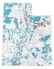
When the FCC employed census blocks for Form 477 broadband coverage mapping in 2014, thousands of rural Utah addresses (red) suddenly appeared as covered by the expanded census block service areas (blue).
|
By Bert Granberg | July 26, 2017
I think I’ll start with a teaser...whether or not you have been, or are currently actively involved in the mapping of broadband services, I think you’ll find this post of direct interest.
On July 13, the FCC released a Further Notice of Proposed Rulemaking (FNPR) related to Form 477 broadband data collection. The FCC seeks comments during the 30-day public comment period which ends on August 12. This is a chance for you to weigh in on an important nationwide data collection tool.
Here’s just a bit of background before we get to the stuff that I hope has the broadest appeal to NSGIC and friends.
The FCC’s Form 477 is the primary tool for collecting national broadband data and is a vital input into policy, planning, and citizen/business engagement at the national, state, and local levels. Broadband map data depicting existing service geography and attributes (speeds, technology, and coverage), adoption, and deployment is extremely valuable toward assessing and increasing community capacity and utilization. Economic development and citizen convenience are just two of the many benefits when this data is put to work to maximize broadband capabilities across the country.

NSGIC Announces Staff Addition
Michelle M. Jones Joins Organization as Manager, Membership & Communications
National States Geographic Information Council (NSGIC) announced today that Michelle M. Jones has joined the staff in a newly-created role that spans membership, events management, communications, sponsorship and administration. As manager, membership and communications, Michelle will provide critical support of NSGIC’s organizational growth strategies of increasing reach, accelerating impact and building the NSGIC brand.
“Michelle brings extensive experience in planning and executing mission-critical meetings and projects,” said Molly Schar, NSGIC executive director. “She has great enthusiasm for the work of NSGIC and our member states. I’m confident Michelle will bolster NSGIC’s efforts to provide a robust forum for state-led sharing of best practices and facilitate critical connections across the geospatial ecosystem.”
NSGIC Stands Behind Geospatial Data Act, Lauds New Language Clarifying Intent
By Molly Schar | July 6, 2017
The Geospatial Data Act (S.1253) has been the subject of much discussion in the past couple of weeks after receiving significant attention by some members of the geospatial community concerned about the potential of the proposed legislation to add restrictions to federal procurement of geospatial data and services.
NSGIC - the voice of the states on geospatial issues - continues to support S.1253, expected to be stronger than ever after minor language revisions that clarify the original intent of the bill to substantially strengthen efforts to build a robust national spatial data infrastructure (NSDI) and reduce duplication of data gathering and processing activities. The changes to S.1253 focus on Sections 2 and 11 and clarify that the intent of the bill is not to expand the scope of the Brooks Act or the Federal Acquisition Regulation (FAR).
USGS RFI: Future Landsat Systems
USGS is requesting information from the land imaging community for user requirements for future Landsat systems. Responses to the RFI are due July 14 and are being considered with other inputs for future systems formulation. Respond to the RFI on the FedConnect site and "Search Public Opportunities Only," then with reference number criteria using G17PS00634.
Geospatial Data Act Sets Table for Performance and Accountability
Legislation would benefit taxpayers and entire geospatial community
By Cy Smith | June 26, 2017
For as long as NSGIC has been around – more than 25 years now – we’ve encouraged effective and efficient government through the coordinated development of geographic information and technologies to ensure that information may be integrated at all levels of government.
The Geospatial Data Act (S.1253) does just that. It establishes a clear vision, assigns responsibility, provides authority and ensures oversight by Congress of federal geospatial activities. These improvements will help ensure that the United States is able to build and sustain a robust national spatial data infrastructure (NSDI). Support of this legislation is a critical step toward building more resilient communities by ensuring they will have access to the consistent high-quality data they need.
Let's Rally for GeoWomen!
By Bill Johnson | June 22, 2017
I’ve been thinking about the NSGIC GeoWomen initiative quite a bit since its inception at the Midyear. It feels really important. The more I think about it, the more I am recognizing both the incredible impact that so many important women have made in my life and career, and the potential for more women to be leaders in our profession.
I didn’t think much about it in my formative years, but my grandmother was a fantastic role model. She was a first-generation American from Swedish immigrants and unlike nearly all women of her era, she did not marry as a late teen and settle into a life of limited domestic boundaries. Instead, she earned a 2-year college degree and quickly worked her way up to being the administrative assistant (in the title of Secretary) to the mayor of Worcester, MA. Knowing how driven and organized she was, it’s easy for me to speculate that she had a strong hand in running the city while the mayor did the glad-handing work. She didn’t marry until age 26 (a true “spinster” in 1918) and later ran my grandfather’s homebuilding business, his lumberyard, and also a summer boarding house at Moody Beach in Maine. Anna O. Johnson was the undisputed matriarch and center of the extended Johnson family when I was growing up.
NSGIC - State GIS Council Partnership
By Bert Granberg | June 7, 2017
A goal of mine, a few years back during my first year as AGRC's director was to facilitate increased 'enterprise GIS' interest and involvement of our state GIS association, the Utah Geographic Information Council (UGIC), a standalone 501c3 nonprofit.
One of the coolest things about professionals in the GIS field is that most of us value strategic problem solving approaches that reach beyond the domains of our individual assignments or agency responsibilities. GIS'ers have a strong tendency to look out for the 'whole' where others might not. While everybody in our field knows the vast degree to which the ‘enterprise of GIS’ in Utah is dependent on data sharing -- especially local to state government -- it is largely undersung to decision makers. Getting UGIC more interested in telling this story well seemed like a natural fit.
Latin for GIS Professionals
By Bill Johnson | June 2, 2017
You have, I am sure, seen the Latin phrase carpe diem, which translates literally to “seize the day.” In modern usage, carpe diem is sometimes equated to “living in the moment,” taking pleasure in the here and now without regard for the future, and occasionally even an ode to hedonism. But the more important definition, in my opinion, is to take a chance, to go above and beyond what might be expected, to take full advantage of an opportunity, to stretch yourself in pursuit of the issue before you right now. This is a credo that I can embrace, and with the clarity of hindsight, I now recognize that it has been a recurring theme in the best examples of GIS projects I’ve had the good fortune to be involved with over the years.
I’ll venture a guess that Latin scholars won’t like this, but I would like to offer a twist on carpe diem as it applies to those of us in the GIS profession: carpe geo, seize the GIS opportunity. I was honored to be the closing keynote speaker at the Utah Geographic Information Council conference in Park City this year, and I introduced carpe geo as part of my talk. It seemed to resonate well with the audience, well enough to embolden me to write this blog post to circulate it further.
Moving Change: The Importance of Small, Unsung Benefits
 By Bert Granberg | June 1, 2017 By Bert Granberg | June 1, 2017
This isn’t original but it's worth restating.
Maybe ‘change’ is so difficult because it’s so hard to know ‘when’ it’s the right time? That applies to life in general, but certainly to technology fields, like ours. In fact, there’s a whole body of study around the risk and benefit calculations made around technology, including my favorite description, the technology adoption life cycle. I am thinking about this today because I just had my first success with Esri’s latest GIS software product platform, ArcPro.
I am pretty sure that I am not considered an ‘Innovator’ or ‘Early Adopter’ for this change, especially considering how many GIS shops seem to bite instantly on the ‘you have to move now to version x.x’ hook without much thought. But maybe I am making the ‘Early Majority’ cut? It doesn’t really matter. It did, however, remind me of previous GIS software transitions that I’ve been involved in. And the common thread for those was, surprisingly, never the most hyped, flashy functionality.
Major Movement for NSGIC Legislative Priorities
By Molly Schar | May 6, 2017
Both the Geospatial Data Act and the Digital Coast Act had big days yesterday. The bills are making their way through the 115th Congress after stalling out in prior years.
The Geospatial Data Act of 2017 was introduced yesterday by Senators Orrin Hatch (R-UT), Mark Warner (D-VA), Dean Heller (R-NV) and Ron Wyden (D-OR) as S.1253. Over the course of the last few years, NSGIC has worked closely with other stakeholders to provide input with the states' perspective on improving the coordination and use of geospatial data.
NSGIC president Bert Granberg said this upon the bill's reintroduction: "From transportation, to natural resources, to homeland security, map-based digital information has quietly become mission critical to how work gets done and to future economic growth. We need an efficiency and accountability framework to build, sustain, and share geographic data assets for the entire nation. The GDA delivers just that." (Read more in the press releases put out by Senator Hatch and Senator Warner.)
Longtime NSGIC Member Joy Paulus to Retire
 Washington State GIS Coordinator Joy Paulus is just four days away from retirement. With 30 years of experience in the use, implementation and management of geospatial data and delivery of service, Joy first became a NSGIC member in 2002. Her GIS career took her to Arizona, Vermont, and finally, Washington, where she became the GIS coordinator for the state in 2007. Her awards for environmental data management and coordination include the Washington Governing for Results Award, Efficiency in State Government Award, and Esri Special Achievement in GIS Award. Joy served NSGIC in leadership roles as a committee volunteer and frequent presenter at conferences and meetings. Washington State GIS Coordinator Joy Paulus is just four days away from retirement. With 30 years of experience in the use, implementation and management of geospatial data and delivery of service, Joy first became a NSGIC member in 2002. Her GIS career took her to Arizona, Vermont, and finally, Washington, where she became the GIS coordinator for the state in 2007. Her awards for environmental data management and coordination include the Washington Governing for Results Award, Efficiency in State Government Award, and Esri Special Achievement in GIS Award. Joy served NSGIC in leadership roles as a committee volunteer and frequent presenter at conferences and meetings.
A few years ago, Joy shared her favorite quote with us, from Mary Oliver: "Tell me, what is it you plan to do with your one wild and precious life?" A fitting sentiment as Joy turns the page to a new chapter in her life. Best of luck, Joy, and thanks for everything!
We're Hiring: Membership & Communications Coordinator
NSGIC seeks to fill a recently created position to coordinate the association's operations, including membership, event management, communications, sponsorship and administration. The Membership & Communications Coordinator will work closely with NSGIC's Executive Director to assure the organization's operations are consistently functioning at a high level and exceed member service expectations.
To apply, applicants should submit their resumes with letters of interest to NSGIC Executive Director Molly Schar at [email protected]. Applications must be received by June 15, 2017.
An SEO Goal for Geospatial Data
 By Bert Granberg | May 23, 2017 By Bert Granberg | May 23, 2017
I spent an hour or so this rainy weekend planning for a future trip to Nevada’s Great Basin National Park. (Hang in there, this post is actually about geospatial data and search engine optimization - SEO).
Specifically, I wanted to print out a few areas of the USGS 1:24,000 scale topographic quad maps for the Wheeler Peak portion of the park, which by all accounts includes some delicious spring ski touring terrain.
And as luck would have it, that area of the park falls on the boundary of the Wheeler Peak and Windy Peak USGS quad maps. Ideally, I wanted the plain-jane, collarless, georeferenced files for each map, so I could load them into GIS or an image manipulation app (photoshop, gimp, etc.) and print out just the areas I needed. And, bonus points go to the data stewards if I could do so while avoiding any and all of the following: creating yet another user account, suffering through undesired ads and mouse clicks, downloading additional unneeded bulky data layers, paying fees to resellers of public domain info, and feeling like I was risking infecting my machine with ‘who knows what?’ packed into a download file. Basically, I wanted just the facts, from a trusted, unobtrusive source.
Ruminations on Open Geodata Taxonomy (or lack thereof)
By Bill Johnson | April 13, 2017
Taxonomy (noun) – a scheme of classification
If you were at the recent Midyear conference, you may recall we had a panel of open data experts fielding questions from the audience. Yours truly asked for the microphone and confessed to being “stuck”, since there seems to be no good way to ensure that all of the various open data sites and platforms and cataloging systems can share catalogs to their content, because they don’t use a common set of terms. This seems analogous to every library using their own unique system to catalog their books. That’s probably how libraries started, but we all know that today there are standards in place that make each library a searchable node in an extensive library network. We lack that today for open geodata. Typical open data sites support searchable metadata and keywords or tags as the method for making data discoverable. But since any given dataset can be described in an infinite variety of ways, the current situation supports only a limited (and unpredictable) amount of cross-platform catalog sharing. What we need is a common taxonomy.
Geography on the Brain - Spring Break
 By Bert Granberg | Mar. 20, 2017 By Bert Granberg | Mar. 20, 2017
NSGIC, and spatial thinking in general, are hard habits to break. For those interested in building meaningful state and national digital mapping resources, the camaraderie and synergy of NSGIC conferences, committees, and professional networking is hard to beat.
But, if you’re like me, very occasionally you find yourself engaged in some weird (to others) NSGIC or geography-inspired activity even when trying to get away from it all.
This happened on a road trip to southern Utah and northern Arizona last week. On day 2 of our spring break trip, my family suddenly found ourselves playing a modified version on the license plate game while hiking Zion National Park’s Angels Landing trail with, oh, about 1000 or more of our fellow park goers.
State Feedback: What I Need Most from NSGIC
By Bert Granberg | Jan. 20, 2017
At a State Caucus session during NSGIC’s Annual Conference in Indianapolis last October, we conducted a completely impromptu exercise that produced some interesting, important information. The game was pretty simple. Take one of the ubiquitous hotel notepads and fill in the blank: “What I need most from NSGIC is _______.”
I can’t remember the specifics of what spawned this, but it was time well spent. Here (below) is what we heard. (Thanks to Molly Schar for summarizing the results!)
… help me tap into the collective wisdom of NSGIC members
Community Resilience Indicators and National-Level Measures: A Draft Interagency Concept | FEMA.gov
By Phil Worrall | Jan. 10, 2017
Source: Community Resilience Indicators and National-Level Measures: A Draft Interagency Concept | FEMA.gov
White House Office of Management and Budget Releases New Report to Support Community Resilience
By Phil Worrall | Jan. 9, 2017
On December 21, the White House Office of Management and Budget (OMB) released a new report titled "Standards and Finance to Support Community Resilience," the culmination of collaboration with leaders in re/insurance, catastrophe modeling and building science to advance community resilience and insurability.
The White House: Supporting Resilient Communities: Leaders in the insurance industry are announcing new investments to support resilient communities - Here's Why
NAFSMA Press Release: White House Office of Management and Budget Releases New Report to Support Community Resilience
NENA NG9-1-1 GIS Data Model Available for Public Review
By Cheryl Benjamin | Jan. 9, 2017
The National Emergency Number Association (NENA) recently released the NENA Standard for Next Generation 9-1-1 (NG9-1-1) GIS Data Model for public review. Under development for over 6 years, the NG9-1-1 GIS Data Model is designed to support civic location address data management in a NG9-1-1 System. NENA was a major participant in the development of the FGDC’s United States Thoroughfare, Landmark, and Postal Address Data Standard and closely aligned the NG9-1-1 Data Model to the FGDC Standard, but it does have some differences.
The public is invited to review the document and submit comments following the instructions below (direct link https://dev.nena.org/kws/public/document?document_id=9828&wg_abbrev=csds-gis). Comments will be accepted until February 28.
Why NSGIC? My Top 3
By Bert Granberg | Jan. 3, 2017
 At NSGIC’s 2016 Annual Conference (NSGIC’s 25th!), I shared a few slides describing why Utah has been involved with NSGIC since its inception, and has attended every NSGIC meeting. Just a couple months into my term as NSGIC’s board president, I thought I’d take a brief respite to revisit and reflect on why it’s all worthwhile. At NSGIC’s 2016 Annual Conference (NSGIC’s 25th!), I shared a few slides describing why Utah has been involved with NSGIC since its inception, and has attended every NSGIC meeting. Just a couple months into my term as NSGIC’s board president, I thought I’d take a brief respite to revisit and reflect on why it’s all worthwhile.
CREAT Climate Scenarios Projection Map
EPA's Climate Resilience Evaluation and Awareness Tool (CREAT) Climate Scenarios Projection Map. This map provides easy-to-access scenario-based climate change projections drawn from CREAT. The impacts from a changing climate, including extreme heat and more intense storms, present challenges to water, wastewater and stormwater utilities and the communities they serve. Understanding how climate change may affect a utility's ability to maintain and deliver adequate, reliable and sustainable water supplies and clean water services is the first step in climate-related planning.
This story map was created with the Story Map Series application in ArcGIS Online.
Contributed by: Nathalie Smith | Source: CREAT Climate Scenarios Projection Map
FACT SHEET: Obama Administration Highlights Opportunities for Building Community Climate Resilience across the Nation
 By Phil Worrall | Nov. 3, 2017 By Phil Worrall | Nov. 3, 2017
Today, the Council on Climate Preparedness and Resilience released its "Resilience Opportunities" report, describing key Administration accomplishments and highlighting opportunities for federal agencies and stakeholders to work together on a shared climate resilience agenda.
Today's "Resilience Opportunities" report builds on lessons learned and outlines three major areas where opportunities exist for innovation, economic growth and collaboration: through application of science-based data and tools, support for community resilience initiatives and integration of climate resilience into federal agency mission, operations and culture.
National States Geographic Information Council (NSGIC) has been awarded $300,000 by the bipartisan Democracy Fund Voice organization for the second phase of NSGIC’s Geo-Enabled Elections project. This continues a national effort by state government geospatial information officers and coordinators to work with other state agencies, local elections officials and state elections offices, national GIS (geographic information system) and elections organizations, and federal partners to identify opportunities to leverage this powerful technology to strengthen elections management and citizen engagement.
National States Geographic Information Council (NSGIC) has released its biennial comprehensive Geospatial Maturity Assessment (GMA) report, which provides NSGIC members and other partners with a summary of geospatial initiatives, capabilities, and issues within and across state governments. For the first time, NSGIC has modified the GMA survey to produce report cards for each state on central data themes and coordination topics.
The 2019 GMA, augmented with individual state report cards and framework data theme analysis, is an authoritative resource on the status of state geospatial programs. This deeper dive can assist states in setting goals, identifying peer states for collaboration, pinpointing areas requiring attention, and connecting states with opportunities and resources. It also provides an important tool for federal partners to identify areas for key coordination, cooperation, and collaboration, and for the private sector to build software and services that comprise the tools that make it all work.
read more
Statement on the Value of GIS in the Pandemic
The spread and effects of COVID-19 can be best understood considering space and time.
April 17, 2020
As governments are responding to COVID-19, more leaders are recognizing the value of “knowing the where.” The importance of knowing where the outbreak is growing, where high-risk populations are, where the hospital beds and important medical resources are, and where to deploy resources is essential. “Knowing the where” informs better decision-making.
In an effort to better understand the where, governments are recognizing the value of geospatial information and technologies and are engaging geospatial professionals to help them better understand the where to help them in their decision-making and response. Geospatial professionals bring unique analytical and visualization skills to the table that help responders and decision-makers visualize where the pandemic is spreading more quickly and can make the important decisions regarding where response and resource needs need to be focused. The value of telling the story through a map coupled with a geospatial dashboard provides a view of the event not readily seen in a table such as a spreadsheet. Beyond visualizing existing data, we can connect data from a location perspective, which enhances the value of the data sources being integrated. Equally important in this event is data on COVID-19 cases and testing packaged and shared in a way useful to scientists.
read more
Partner Spotlight: GeoComm
By GeoComm | September, 2020
Today public safety GIS data and location information is disparate, inconsistent, and expanding. Public Safety Location Intelligence from GeoComm provides a new way to get the right location information, on the right map, for the right people, at the right time, in order to respond to emergency calls faster.
In an emergency every second counts and GIS data has never played a more important role in mission critical public safety. Today when a 9-1-1 call is placed, a patchwork of technology provides limited additional data about the location on different screens or in different applications, hurting our ability to utilize all of the valuable location content available to support emergency response.
|