

Sponsor Spotlight: NV5 GeospatialNV5 Geospatial Expands Breadth of Deep-Water and Near-Shore Survey Offerings with Acquisition of Geodynamics By NV5 Geospatial | June 25, 2021 
With the recent acquisition of Geodynamics LLC, NV5 Geospatial has built one of the most comprehensive suites of solutions for geospatial surveys of deep water and near-shore environments. The combination brings together complementary, advanced technologies – Geodynamics’ full-ocean depth sonar-based hydrographic and geophysical surveying with NV5 Geospatial’s topographic and bathymetric capabilities – to deliver detailed insights for a variety of applications, including coastal management, flood monitoring, ecosystem protection, research, and more. “This acquisition was a natural evolution toward our common goal of delivering valuable geospatial insights to our clients,” said Kurt Allen, vice president, Federal Vertical for NV5 Geospatial, North America’s largest and most comprehensive geospatial firm. “Our decades of combined experience and expertise using the most sophisticated technology for data acquisition and analysis will enable us to meet the most demanding client requirements.” 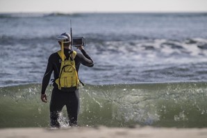
Only a handful of firms in North America share NV5 Geospatial’s topobathymetric and bathymetric capabilities at any level, much less have mastery of the science. We lead our peers in acquisition capabilities. We deploy leading-edge sensors like our newly acquired RIEGL 840 G. We have world-class experts managing the challenging data processing and developing informed answers that our government and commercial clients demand. In 2020 NV5 Geospatial completed the collection of topographic and bathymetric lidar and digital imagery for the National Oceanic and Atmospheric Administration’s (NOAA) largest coastal mapping project. These efforts included updating information for 12,000 square miles along the Eastern Seaboard, Pacific, and Gulf Coast that have not been surveyed for hundreds of years. 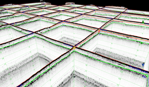
This specialized capability allows NV5 Geospatial clients to significantly increase their knowledge of the near-shore environment for improved marine resource mapping, benthic habitat mapping, shoreline delineation, nautical charting, and marine debris mapping. Now, combined with the services of Geodynamics, NV5 Geospatial can take you from the mountaintop to the seafloor and allow our client’s curiosity to take new heights as we go to deeper depths to answer their most challenging questions. Geodynamics is a pioneer in collecting and processing multibeam, single beam, sidescan, geophysical, and acoustic backscatter hydrographic data. They are known for executing data acquisition in some of the most challenging coastal environments, including dynamic tidal inlets, high-energy surf zones, and rapidly changing shoal systems that challenge navigation. Geodynamics has completed large-scale hydrographic survey projects in the coastal and adjacent ocean areas of the entire United States, including detailed hydrographic surveys to support federal nautical chart updates in the Atlantic, Gulf of Mexico, and Great Lakes region for NOAA Office of Coast Survey. 
Geodynamics’ offshore geophysical surveys have supported mapping marine minerals, benthic habitats, and potential submerged archaeological resources with a research focus on coastal geology. For example, they have executed numerous multi-sensor surveys for the US Army Corps of Engineers, the EPA, BOEM, and local government entities to identify and monitor offshore sediment resources that can be used to enhance beaches and protect coastal communities from storm-induced erosion and inundation. To combine our capabilities in ocean science and geospatial data services, NV5 Geospatial and Geodynamics created a joint venture in 2019. Working collaboratively as MarineGeoSpatial LLC, the partnership provides aerial and ship-based remote sensing for offshore/marine survey and data collection, mapping and data analysis, and marine enterprise GIS services. “We are excited to embark on this new chapter with NV5. It is the perfect strategic alignment of aerial, subsea survey, and geospatial services,” said Geodynamics CEO Sloan Freeman, PLS. “Together, we have the technology, tools, and experience to provide the best solutions to our clients and continue to advance scientific knowledge about coastal environments.” 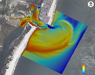
|